


Summary
Carter Dome, or simply The Dome,[3] is a mountain located in Coos County, New Hampshire. The mountain is part of the Carter-Moriah Range of the White Mountains, which runs along the northern east side of Pinkham Notch. Carter Dome is flanked to the northeast by Mount Hight and to the southwest by Wildcat Mountain (across Carter Notch).
| Carter Dome | |
|---|---|
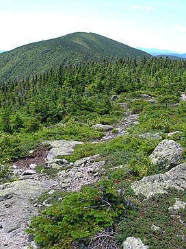 Carter Dome seen from Mt. Hight | |
| Highest point | |
| Elevation | 4,832 ft (1,473 m)[1] |
| Prominence | 2,821 ft (860 m)[1] |
| Listing | White Mountain 4000-Footers #12 New England 50 Finest |
| Coordinates | 44°16′02″N 71°10′44″W / 44.2672877°N 71.1789625°W[2] |
| Geography | |
| Location | Coös County, New Hampshire, U.S. |
| Parent range | Carter-Moriah Range |
| Topo map | USGS Carter Dome |
The origins of Carter Dome's name is unknown. Local folklore suggests that it was named after a hunter named Carter, while a neighboring peak is named after his hunting partner, Hight.[4]
The mountain is ascended from the west by the Carter Dome Trail and Nineteen Mile Brook Trail, and from the east by the Black Angel Trail.[5]
Climate edit
Carter Dome has a humid continental climate (Köppen Dfb), closely bordering on a subarctic climate (Köppen Dfc), with September only just averaging over 10°C, making there four months with an average temperature of 10°C or more. For a climate to be classified as subarctic, it must have an average temperature of at least 10°C for one month but no more than three months, whereas humid continental climates have four or more months.
| Climate data for Carter Dome 44.2652 N, 71.1739 W, Elevation: 4,472 ft (1,363 m) (1991–2020 normals) | |||||||||||||
|---|---|---|---|---|---|---|---|---|---|---|---|---|---|
| Month | Jan | Feb | Mar | Apr | May | Jun | Jul | Aug | Sep | Oct | Nov | Dec | Year |
| Mean daily maximum °F (°C) | 17.8 (−7.9) |
19.5 (−6.9) |
25.8 (−3.4) |
37.6 (3.1) |
50.3 (10.2) |
58.8 (14.9) |
63.3 (17.4) |
62.1 (16.7) |
56.8 (13.8) |
44.8 (7.1) |
31.9 (−0.1) |
23.3 (−4.8) |
41.0 (5.0) |
| Daily mean °F (°C) | 10.1 (−12.2) |
11.3 (−11.5) |
17.9 (−7.8) |
29.8 (−1.2) |
43.3 (6.3) |
52.6 (11.4) |
57.4 (14.1) |
56.1 (13.4) |
50.0 (10.0) |
37.8 (3.2) |
25.5 (−3.6) |
15.9 (−8.9) |
34.0 (1.1) |
| Mean daily minimum °F (°C) | 2.3 (−16.5) |
3.2 (−16.0) |
9.9 (−12.3) |
21.9 (−5.6) |
36.3 (2.4) |
46.3 (7.9) |
51.6 (10.9) |
50.1 (10.1) |
43.1 (6.2) |
30.8 (−0.7) |
19.1 (−7.2) |
8.4 (−13.1) |
26.9 (−2.8) |
| Average precipitation inches (mm) | 5.60 (142) |
4.78 (121) |
5.66 (144) |
6.90 (175) |
6.44 (164) |
7.13 (181) |
6.95 (177) |
6.00 (152) |
5.98 (152) |
9.46 (240) |
7.10 (180) |
6.74 (171) |
78.74 (1,999) |
| Source: PRISM Climate Group[6] | |||||||||||||
See also edit
References edit
- ^ a b "Carter Dome, New Hampshire". Peakbagger.com. Retrieved 2013-02-01.
- ^ "Carter Dome". Geographic Names Information System. United States Geological Survey, United States Department of the Interior. Retrieved 2013-02-01.
- ^ Steve Eastman. Fire Lookouts of Old, The Mountain Ear, 1988.
- ^ Lillard, David. E. (2002). Appalachian Trail Names. Stackpole Books. ISBN 9780811726726. Retrieved 2008-06-16.
- ^ "Carter Dome". Hikethewhites.com. Retrieved 2011-10-31.
- ^ "PRISM Climate Group, Oregon State University". PRISM Climate Group, Oregon State University. Retrieved October 20, 2023.
To find the table data on the PRISM website, start by clicking Coordinates (under Location); copy Latitude and Longitude figures from top of table; click Zoom to location; click Precipitation, Minimum temp, Mean temp, Maximum temp; click 30-year normals, 1991-2020; click 800m; click Retrieve Time Series button.
External links edit
- "Hiking Carter Dome". Appalachian Mountain Club.
- "Carter Dome". SummitPost.org.