


Summary
Lisbon Cascais-Tejo Regional Airport (Cascais Municipal Aerodrome) (Portuguese: Aeródromo de Tires/Aeródromo Municipal de Cascais) (IATA: CAT, ICAO: LPCS)[1] is a regional airport, situated near the village of Tires, in the civil parish of São Domingos de Rana, in the Portuguese municipality of Cascais, approximately 12 km (7.5 mi) northeast of town of the same name in the Greater Lisbon subregion.
Lisboa Cascais-Tejo Regional Airport; Aeroporto Regional Lisboa Cascais-Tejo Cascais Municipal Aerodrome;
Aeródromo Municipal de Cascais Aeródromo de Tires | |||||||||||
|---|---|---|---|---|---|---|---|---|---|---|---|
 | |||||||||||
| Summary | |||||||||||
| Airport type | Public | ||||||||||
| Operator | Cascais E.M. | ||||||||||
| Location | Tires, São Domingos de Rana, Portugal | ||||||||||
| Elevation AMSL | 326 ft / 99 m | ||||||||||
| Coordinates | 38°43′32″N 009°21′19″W / 38.72556°N 9.35528°W | ||||||||||
| Website | www.aerodromo-cascais.pt | ||||||||||
| Map | |||||||||||
 LPCS Location in Portugal | |||||||||||
| Runways | |||||||||||
| |||||||||||
History edit
On 11 October 1964, the then-President of the Portuguese Republic, Américo Tomás inaugurated the Aerodrome of Tires.[3] The project was born of the initiatives of the Secretary-of-State for Aeronautics and Directorate-general for Civil Aeronautics, as well as the Count of Monte Real.[3] The aerodrome was planned for the area around Areia-Guincho, but installed in Tires, a project of the Directorate and earthmoving performed by the military aeronautics division.[3] By 1973, work on the local was still continuing.[3]
Airlines and destinations edit
The following airlines operate regular scheduled and charter flights at Cascais Airport:[4]
| Airlines | Destinations |
|---|---|
| Sevenair | Bragança, Portimão, Viseu, Vila Real |
Location edit
Coordinates
| LAT | N* 38º 43' 32" |
| LNG | W* 09º 21' 19" |
- Localização
Located in Tires, on av. Amália Rodrigues, the airfield is located in the tourist area of the Estoril Coast, more precisely in São Domingos de Rana, municipality of Cascais.
Characteristics edit
edit
The aerodrome has two radio navigation aids, a locator-type NDB and a TVOR/DME.
Track edit
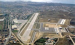
The airfield has a runway 1,400 meters long and 30 meters wide, made of asphalt concrete (PCN20) at an altitude of 326 feet. The runway is prepared to receive traffic of up to 40 tons and also has light signaling, approach lights and the Apapis system.
Heliport edit
The airfield also has a helipad, where an INEM (National Institute of Medical Emergency) helicopter is available 24 hours a day.
Operators edit
This location is where many of the country's aviation schools are concentrated, as it is near the capital of Portugal and the country's largest population centre.
References edit
Notes edit
- ^ a b "Airline and Location Code Search".
- ^ AIP Part 3 - AD 2 Aerodromes Archived April 15, 2012, at the Wayback Machine
- ^ a b c d Figueiredo, Paula (2010). SIPA (ed.). "Aeródromo de Tires (IPA.000305401/PT031105060408)" (in Portuguese). Lisbon, Portugal: SIPA–Sistema de Informação para o Património Arquitectónico. Retrieved 30 April 2017.
- ^ "Horários Fly Sevenair entre Bragança e Portimão".
Sources edit
- Encarnação, José de (1975), Cascais - Vila da Corte. Oito séculos de história (in Portuguese), Cascais, Portugal: Câmara Municipal de Cascais
External links edit
![]() Media related to Cascais Municipal Aerodrome at Wikimedia Commons
Media related to Cascais Municipal Aerodrome at Wikimedia Commons
- Official website (in Portuguese and English)