
KNOWPIA
WELCOME TO KNOWPIA

Castelnaud-la-Chapelle 
Summary
Castelnaud-la-Chapelle (French pronunciation: [kastɛlno la ʃapɛl]; Occitan: Castelnòu e La Capèla) is a commune in the Dordogne department in Nouvelle-Aquitaine in southwestern France.
Castelnaud-la-Chapelle | |
|---|---|
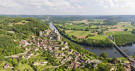 View of Castelnaud-la-Chapelle and its castle | |
Location of Castelnaud-la-Chapelle .mw-parser-output .locmap .od{position:absolute}.mw-parser-output .locmap .id{position:absolute;line-height:0}.mw-parser-output .locmap .l0{font-size:0;position:absolute}.mw-parser-output .locmap .pv{line-height:110%;position:absolute;text-align:center}.mw-parser-output .locmap .pl{line-height:110%;position:absolute;top:-0.75em;text-align:right}.mw-parser-output .locmap .pr{line-height:110%;position:absolute;top:-0.75em;text-align:left}.mw-parser-output .locmap .pv>div{display:inline;padding:1px}.mw-parser-output .locmap .pl>div{display:inline;padding:1px;float:right}.mw-parser-output .locmap .pr>div{display:inline;padding:1px;float:left}html.skin-theme-clientpref-night .mw-parser-output .od,html.skin-theme-clientpref-night .mw-parser-output .od .pv>div,html.skin-theme-clientpref-night .mw-parser-output .od .pl>div,html.skin-theme-clientpref-night .mw-parser-output .od .pr>div{background:#000;color:#fff}html.skin-theme-clientpref-night .mw-parser-output .locmap{filter:grayscale(0.6)}@media(prefers-color-scheme:dark){html.skin-theme-clientpref-os .mw-parser-output .locmap{filter:grayscale(0.6)}html.skin-theme-clientpref-os .mw-parser-output .od,html.skin-theme-clientpref-os .mw-parser-output .od .pv>div,html.skin-theme-clientpref-os .mw-parser-output .od .pl>div,html.skin-theme-clientpref-os .mw-parser-output .od .pr>div{background:#000;color:#fff}}  Castelnaud-la-Chapelle  Castelnaud-la-Chapelle | |
| Coordinates: 44°48′57″N 1°08′58″E / 44.8158°N 1.1494°E | |
| Country | France |
| Region | Nouvelle-Aquitaine |
| Department | Dordogne |
| Arrondissement | Sarlat-la-Canéda |
| Canton | Vallée Dordogne |
| Government | |
| • Mayor (2020–2026) | Daniel Dejean[1] |
| Area 1 | 20.88 km2 (8.06 sq mi) |
| Population (2021)[2] | 447 |
| • Density | 21/km2 (55/sq mi) |
| Time zone | UTC+01:00 (CET) |
| • Summer (DST) | UTC+02:00 (CEST) |
| INSEE/Postal code | 24086 /24250 |
| Elevation | 51–283 m (167–928 ft) (avg. 71 m or 233 ft) |
| 1 French Land Register data, which excludes lakes, ponds, glaciers > 1 km2 (0.386 sq mi or 247 acres) and river estuaries. | |
The Château de Castelnaud-la-Chapelle is located in the commune.
Geography edit
The river Céou flows northward through the western part of the commune, then flows into the Dordogne, which forms all of the commune's northern border.
The village is located above the confluence of the two rivers.
Population edit
| Year | Pop. | ±% |
|---|---|---|
| 1962 | 497 | — |
| 1968 | 440 | −11.5% |
| 1975 | 380 | −13.6% |
| 1982 | 374 | −1.6% |
| 1990 | 408 | +9.1% |
| 1999 | 426 | +4.4% |
| 2008 | 470 | +10.3% |
| 2018 | 452 | −3.8% |
See also edit
References edit
- ^ "Répertoire national des élus: les maires" (in French). data.gouv.fr, Plateforme ouverte des données publiques françaises. 4 May 2022.
- ^ "Populations légales 2021". The National Institute of Statistics and Economic Studies. 28 December 2023.
External links edit
Wikimedia Commons has media related to Castelnaud-la-Chapelle.
- English Website of the Château de Castelnaud
- Château de Castelnaud
- Camping de Castelnaud