


Summary
Cecilia Island is the ice-free southernmost island of the Aitcho group on the west side of English Strait in the South Shetland Islands, Antarctica. Extending 910 by 450 m (1,000 by 490 yd), surface area 36 hectares (89 acres).[1] The area, visited by American and English sealers in the early 19th century, nowadays has become a popular tourist site frequented by Antarctic cruise ships.
 | |
 Location of Cecilia Island | |
 Cecilia Island  Cecilia Island | |
| Geography | |
|---|---|
| Location | Antarctica |
| Coordinates | 62°24′46.2″S 59°43′42.6″W / 62.412833°S 59.728500°W |
| Archipelago | Aitcho group |
| Area | 36 ha (89 acres) |
| Length | 910 m (2990 ft) |
| Width | 450 m (1480 ft) |
| Administration | |
| Administered under the Antarctic Treaty System | |
| Demographics | |
| Population | uninhabited |
The feature's name derives from 'Cecilias Straits' applied to English Strait by Captain John Davis after the shallop Cecilia, tender to his ship Huron that visited the South Shetlands in 1820–22. It was from the Cecilia that the first landing on the Antarctic mainland was made at Hughes Bay on 7 February 1821.
Location edit
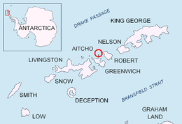
The midpoint is located at 62°24′46.2″S 59°43′42.6″W / 62.412833°S 59.728500°W and the island is lying 3.07 km (1.91 mi) north of Spark Point, Greenwich Island, 2.07 km (1.29 mi) east-northeast of Dee Island, 280 m (310 yd) southeast of Barrientos Island, 3.39 km (2.11 mi) southwest of Debelyanov Point, Robert Island and 4.83 km (3.00 mi) west of Negra Point, Robert Island (Chilean mapping in 1961, British in 1968, Argentine in 1980, and Bulgarian in 2005 and 2009).

See also edit
Map edit
- L.L. Ivanov et al. Antarctica: Livingston Island and Greenwich Island, South Shetland Islands. Scale 1:100000 topographic map. Sofia: Antarctic Place-names Commission of Bulgaria, 2005.
References edit
External links edit
- SCAR Composite Antarctic Gazetteer.