
KNOWPIA
WELCOME TO KNOWPIA

Cepoy 
Summary
Cepoy (French pronunciation: [səpwa]) is a commune in the Loiret department in north-central France.
Cepoy | |
|---|---|
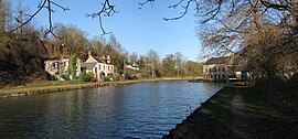 The Loing Canal at the south west of Cepoy | |
 Coat of arms | |
Location of Cepoy .mw-parser-output .locmap .od{position:absolute}.mw-parser-output .locmap .id{position:absolute;line-height:0}.mw-parser-output .locmap .l0{font-size:0;position:absolute}.mw-parser-output .locmap .pv{line-height:110%;position:absolute;text-align:center}.mw-parser-output .locmap .pl{line-height:110%;position:absolute;top:-0.75em;text-align:right}.mw-parser-output .locmap .pr{line-height:110%;position:absolute;top:-0.75em;text-align:left}.mw-parser-output .locmap .pv>div{display:inline;padding:1px}.mw-parser-output .locmap .pl>div{display:inline;padding:1px;float:right}.mw-parser-output .locmap .pr>div{display:inline;padding:1px;float:left}html.skin-theme-clientpref-night .mw-parser-output .od,html.skin-theme-clientpref-night .mw-parser-output .od .pv>div,html.skin-theme-clientpref-night .mw-parser-output .od .pl>div,html.skin-theme-clientpref-night .mw-parser-output .od .pr>div{background:#000;color:#fff}html.skin-theme-clientpref-night .mw-parser-output .locmap{filter:grayscale(0.6)}@media(prefers-color-scheme:dark){html.skin-theme-clientpref-os .mw-parser-output .locmap{filter:grayscale(0.6)}html.skin-theme-clientpref-os .mw-parser-output .od,html.skin-theme-clientpref-os .mw-parser-output .od .pv>div,html.skin-theme-clientpref-os .mw-parser-output .od .pl>div,html.skin-theme-clientpref-os .mw-parser-output .od .pr>div{background:#000;color:#fff}}  Cepoy  Cepoy | |
| Coordinates: 48°02′50″N 2°44′16″E / 48.0472°N 2.7378°E | |
| Country | France |
| Region | Centre-Val de Loire |
| Department | Loiret |
| Arrondissement | Montargis |
| Canton | Châlette-sur-Loing |
| Intercommunality | CA Montargoise et Rives du Loing |
| Government | |
| • Mayor (2020–2026) | Régis Guerin[1] |
| Area 1 | 8.52 km2 (3.29 sq mi) |
| Population (2021)[2] | 2,373 |
| • Density | 280/km2 (720/sq mi) |
| Demonym(s) | Cepoyennes, Cepoyens[3] |
| Time zone | UTC+01:00 (CET) |
| • Summer (DST) | UTC+02:00 (CEST) |
| INSEE/Postal code | 45061 /45120 |
| Elevation | 77–114 m (253–374 ft) |
| Website | www.ville-cepoy.fr |
| 1 French Land Register data, which excludes lakes, ponds, glaciers > 1 km2 (0.386 sq mi or 247 acres) and river estuaries. | |

Population edit
| Year | Pop. | ±% p.a. |
|---|---|---|
| 1968 | 1,584 | — |
| 1975 | 1,543 | −0.37% |
| 1982 | 1,856 | +2.67% |
| 1990 | 1,993 | +0.89% |
| 1999 | 2,064 | +0.39% |
| 2007 | 2,308 | +1.41% |
| 2012 | 2,347 | +0.34% |
| 2017 | 2,367 | +0.17% |
| Source: INSEE[4] | ||
See also edit
References edit
- ^ "Répertoire national des élus: les maires" (in French). data.gouv.fr, Plateforme ouverte des données publiques françaises. 13 September 2022.
- ^ "Populations légales 2021". The National Institute of Statistics and Economic Studies. 28 December 2023.
- ^ Le nom des habitants du 45 - Loiret, habitants.fr
- ^ Population en historique depuis 1968, INSEE
Wikimedia Commons has media related to Cepoy.