
KNOWPIA
WELCOME TO KNOWPIA

Cestayrols 
Summary
Cestayrols is a commune in the Tarn department in southern France.
Cestayrols | |
|---|---|
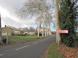 The road into Cestayrols | |
 Coat of arms | |
Location of Cestayrols .mw-parser-output .locmap .od{position:absolute}.mw-parser-output .locmap .id{position:absolute;line-height:0}.mw-parser-output .locmap .l0{font-size:0;position:absolute}.mw-parser-output .locmap .pv{line-height:110%;position:absolute;text-align:center}.mw-parser-output .locmap .pl{line-height:110%;position:absolute;top:-0.75em;text-align:right}.mw-parser-output .locmap .pr{line-height:110%;position:absolute;top:-0.75em;text-align:left}.mw-parser-output .locmap .pv>div{display:inline;padding:1px}.mw-parser-output .locmap .pl>div{display:inline;padding:1px;float:right}.mw-parser-output .locmap .pr>div{display:inline;padding:1px;float:left}html.skin-theme-clientpref-night .mw-parser-output .od,html.skin-theme-clientpref-night .mw-parser-output .od .pv>div,html.skin-theme-clientpref-night .mw-parser-output .od .pl>div,html.skin-theme-clientpref-night .mw-parser-output .od .pr>div{background:#000;color:#fff}html.skin-theme-clientpref-night .mw-parser-output .locmap{filter:grayscale(0.6)}@media(prefers-color-scheme:dark){html.skin-theme-clientpref-os .mw-parser-output .locmap{filter:grayscale(0.6)}html.skin-theme-clientpref-os .mw-parser-output .od,html.skin-theme-clientpref-os .mw-parser-output .od .pv>div,html.skin-theme-clientpref-os .mw-parser-output .od .pl>div,html.skin-theme-clientpref-os .mw-parser-output .od .pr>div{background:#000;color:#fff}}  Cestayrols  Cestayrols | |
| Coordinates: 43°58′52″N 1°59′07″E / 43.9811°N 1.9853°E | |
| Country | France |
| Region | Occitania |
| Department | Tarn |
| Arrondissement | Albi |
| Canton | Les Deux Rives |
| Intercommunality | CA Gaillac-Graulhet |
| Area 1 | 17.03 km2 (6.58 sq mi) |
| Population (2021)[1] | 466 |
| • Density | 27/km2 (71/sq mi) |
| Time zone | UTC+01:00 (CET) |
| • Summer (DST) | UTC+02:00 (CEST) |
| INSEE/Postal code | 81067 /81150 |
| Elevation | 188–282 m (617–925 ft) (avg. 240 m or 790 ft) |
| 1 French Land Register data, which excludes lakes, ponds, glaciers > 1 km2 (0.386 sq mi or 247 acres) and river estuaries. | |
Geography edit
The Vère flows southwestward through the northern part of the commune.
See also edit
References edit
- ^ "Populations légales 2021". The National Institute of Statistics and Economic Studies. 28 December 2023.
Wikimedia Commons has media related to Cestayrols.