
KNOWPIA
WELCOME TO KNOWPIA

Chaillevois 
Summary
Chaillevois (French pronunciation: [ʃajvwa]) is a commune in the Aisne department in Hauts-de-France in northern France.
Chaillevois | |
|---|---|
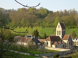 The village of Chaillevois | |
Location of Chaillevois .mw-parser-output .locmap .od{position:absolute}.mw-parser-output .locmap .id{position:absolute;line-height:0}.mw-parser-output .locmap .l0{font-size:0;position:absolute}.mw-parser-output .locmap .pv{line-height:110%;position:absolute;text-align:center}.mw-parser-output .locmap .pl{line-height:110%;position:absolute;top:-0.75em;text-align:right}.mw-parser-output .locmap .pr{line-height:110%;position:absolute;top:-0.75em;text-align:left}.mw-parser-output .locmap .pv>div{display:inline;padding:1px}.mw-parser-output .locmap .pl>div{display:inline;padding:1px;float:right}.mw-parser-output .locmap .pr>div{display:inline;padding:1px;float:left}html.skin-theme-clientpref-night .mw-parser-output .od,html.skin-theme-clientpref-night .mw-parser-output .od .pv>div,html.skin-theme-clientpref-night .mw-parser-output .od .pl>div,html.skin-theme-clientpref-night .mw-parser-output .od .pr>div{background:#000;color:#fff}html.skin-theme-clientpref-night .mw-parser-output .locmap{filter:grayscale(0.6)}@media(prefers-color-scheme:dark){html.skin-theme-clientpref-os .mw-parser-output .locmap{filter:grayscale(0.6)}html.skin-theme-clientpref-os .mw-parser-output .od,html.skin-theme-clientpref-os .mw-parser-output .od .pv>div,html.skin-theme-clientpref-os .mw-parser-output .od .pl>div,html.skin-theme-clientpref-os .mw-parser-output .od .pr>div{background:#000;color:#fff}}  Chaillevois  Chaillevois | |
| Coordinates: 49°30′48″N 3°31′33″E / 49.5133°N 3.5258°E | |
| Country | France |
| Region | Hauts-de-France |
| Department | Aisne |
| Arrondissement | Laon |
| Canton | Laon-1 |
| Intercommunality | Picardie des Châteaux |
| Government | |
| • Mayor (2020–2026) | Philippe Mignot[1] |
| Area 1 | 2.17 km2 (0.84 sq mi) |
| Population (2021)[2] | 187 |
| • Density | 86/km2 (220/sq mi) |
| Time zone | UTC+01:00 (CET) |
| • Summer (DST) | UTC+02:00 (CEST) |
| INSEE/Postal code | 02155 /02000 |
| Elevation | 57–169 m (187–554 ft) (avg. 75 m or 246 ft) |
| 1 French Land Register data, which excludes lakes, ponds, glaciers > 1 km2 (0.386 sq mi or 247 acres) and river estuaries. | |
Geography edit
The river Ailette forms part of the commune's southern border.
The name of this village seems derive from an old path that probably happened in this place, callis via, or royal road. In 1760, most of the villagers made their living from forestry, agriculture or viticulture. The village once belonged to the bishops of Aaon, who lost possession in the French Revolution. It was also the home town of Jean-Baptiste Tholmé, a general in the time of the Revolution.[3]
Population edit
| Year | Pop. | ±% p.a. |
|---|---|---|
| 1968 | 149 | — |
| 1975 | 160 | +1.02% |
| 1982 | 155 | −0.45% |
| 1990 | 174 | +1.46% |
| 1999 | 175 | +0.06% |
| 2007 | 191 | +1.10% |
| 2012 | 183 | −0.85% |
| 2017 | 174 | −1.00% |
| Source: INSEE[4] | ||
See also edit
References edit
- ^ "Répertoire national des élus: les maires". data.gouv.fr, Plateforme ouverte des données publiques françaises (in French). 9 August 2021.
- ^ "Populations légales 2021". The National Institute of Statistics and Economic Studies. 28 December 2023.
- ^ Maximilien Melleville, Dictionnaire historique du département de l'Aisne: A-K Le Livre d'histoire, 1880, p. 137. ISBN 9782844351500
- ^ Population en historique depuis 1968, INSEE
Wikimedia Commons has media related to Chaillevois.