


Summary
Chakulia or Chakuliya is a Notified Area Council (NAC) and 4th Municipal Corporation in the Ghatshila subdivision of the East Singhbhum district in the state of Jharkhand, India.It is 71 km from Jamshedpur City, the district headquarter.
Chakulia | |
|---|---|
Notified Area Council (NAC) | |
| Chakuliya | |
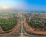
     From top to bottom: Chakulia Sunset, Elephants in Chakulia forest area (L), Chakulia Airport (R), Kanhaiwar hill, Shiv Ram Ashram | |
| Nickname: CKU | |
 Chakulia Location in Jharkhand, India  Chakulia Chakulia (India) | |
| Coordinates: 22°29′N 86°43′E / 22.48°N 86.72°E | |
| Country | |
| State | Jharkhand |
| District | East Singhbhum |
| Government | |
| • Type | Notified Area Council (NAC) |
| • Body | Chakuliya Nagar Panchayat |
| • Executive Officer | Deepak Sahay |
| Area | |
| • Urban | 15.12 km2 (5.84 sq mi) |
| • Rural | 414.21 km2 (159.93 sq mi) |
| Elevation | 115 m (377 ft) |
| Population (2011) | |
| • Notified Area Council (NAC) | 16,306 |
| • Density | 1,078/km2 (2,790/sq mi) |
| Languages * | |
| • Official | Hindi, Santali |
| Time zone | UTC+5:30 (IST) |
| PIN | 832301 |
| Telephone code | 06594 |
| Vehicle registration | JH 05 |
| Website | udhd |
Chakulia is known for its non-operational Chakulia Airport, Kanaishwar Hill, bamboo trees, detergent powder brand "Hindustan Soap Factory" and its beautiful nature. Chakulia is always in news headlines due to hundreds of Elephants roams in Chakulia forest area. Chakulia city gained recent recognition due to the Dhyan Foundation's goushala located at chakulia airport, providing shelter, treatment, and food to thousands of rescued cows from the cattle mafia at the Indo-Bangladesh border.
History edit
An Airfield was built by the British Construction Contractor Mr. Digar Pramotha Nath Mohanty by Das & Mohanty construction company in 1942 to conduct raids against the advancing Japanese in Burma and also for operations to transport aid to parts of China. Also, in 1971, during the war of independence of Bangladesh, a guerrilla training camp was set up and used for training volunteers. Currently, the airport has no scheduled commercial airline flights. In 2006, it was reported that the airport has been non-operational since it served during World War II.
-
 40th BG B-29 42-6310 taking off from Chakulia Airfield, India, June, 1944
 -
 25th Bombardment Squadorn - B-29 Superfortess
 -
 Before Flight
 -
 Emblem of the 40th Bombardment Group


Geography edit


10miles
Wildlife
Sanctuary
River
River
M: municipality, R: rural/ urban centre, CT: census town, T: tourist centre
Owing to space constraints in the small map, the actual locations in a larger map may vary slightly
Location edit
Chakulia is located at 22°29′N 86°43′E / 22.48°N 86.72°E.[1] It has an average elevation of 115 metres (377 feet).[citation needed]
Area overview edit
The area shown in the map “forms a part of the Chota Nagpur Plateau and is a hilly upland tract”. The main rivers draining the district are the Subarnarekha and the Kharkai.[2] The area lying between Jamshedpur and Ghatshila is the main industrial mining zone. The rest of the district is primarily agricultural. In the district, as of 2011, 56.9% of the population lives in the rural areas and a high 43.1% lives in the urban areas.[3]
Note: The map alongside presents some of the notable locations in the district. All places marked in the map are linked in the larger full screen map.
Civic administration edit
There is a police station at Chakulia.[4] The headquarters of Chakulia CD block is located at Chakulia town.[5]
-
 Chakulia Police Station
 -
-
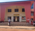
 Chakulia Nagar Panchayat Bhawan


Demographics edit
According to the 2011 Census of India, Chakulia had a total population of 16,306, of which 8,352 (51%) were males and 7,954 (49%) were females. Population in the age range 0–6 years was 2,140. The total number of literate persons in Chakulia was 11,174 (78.88% of the population over 6 years).[6]
Languages edit
(*For language details see Chakulia block#Language and religion)
As of 2001[update] India census,[8] Chakulia had a population of 14,330. Males constitute 52% of the population and females 48%. Chakulia has an average literacy rate of 64%, higher than the national average of 59.5%; with male literacy of 73% and female literacy of 54%. 13% of the population is under 6 years of age.
Economy edit
Chakulia is famous for its detergent soap and powder manufactured by South East Chemical/Hindustan Soap Factory, Rice Mills and also known for bamboo.
Tourism edit
Chakulia, a picturesque town nestled in the heart of Jharkhand, India, offers a delightful array of attractions for visitors to explore and enjoy. From the serene greenery of Nananani Park to the playful ambiance of Children's Park, there's something for everyone to enjoy. Named after the revered tribal leader, Birsa Munda Park celebrates the region's rich cultural heritage, while the upcoming Ecological Diversity Park promises to showcase the area's biodiversity in a grand way. Beyond parks, visitors can explore historical landmarks like the abandoned Chakulia Airport, tranquil spots like Notun Bandh Ghat, and spiritual sites like Kanhaiwar Hill and Shiv Ram Ashram. With its beautiful temples and the captivating Sunsunia Forest, Chakulia invites travelers to immerse themselves in its enchanting ambiance and create unforgettable memories amidst its scenic landscapes and vibrant traditions.
-
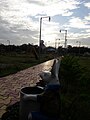 Nananani Park Chakulia
 -
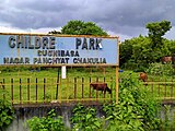 Children's Park Chakulia
 -
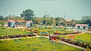 Birsa Munda Park Chakulia
 -
 Chakulia Aerodrome
 -
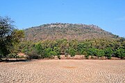 Kanhaiwar Hill


Transportation edit
Chakulia is connected by railway and road, and lies in the Howrah-Mumbai rail route. It is also among the major economic hubs which lie between Jamshedpur and Kharagpur. Trains and transport vehicles are easily available from major nearby cities, such as Kharagpur (West Bengal), Tatanagar (Jharkhand), Baripada (Orissa). Chakulia also has an airfield which was used heavily during the World War II.
-
 Chakulia Station Entrance
 -
 Chakulia Station Building
 -
 Chakulia Station Arts


Education edit
Shibu Ranjan Khan Memorial Degree College was established at Chakuliya in 2010.[9]
K.N.J High School, Chakulia
Ramkrishna Vivekanand International English High School, Chakulia
Shanti Devi Saraswati Shishu Vidya Mandir, Chakulia
Ananda Marga High School, Chakulia
N.D Rungta Girl's High School, Chakulia
Kasturba Gandhi Balika Vidyalaya, Chakulia
Model School, Chakulia
Manohar Lal High School, Chakulia
District Institute of Education and Training, Chakulia
Swami Vivekananda Pvt. ITI, Chakulia
Healthcare edit
- C.H.C, Chakulia .[10]
- Anandlok Hospital, Chakulia.
References edit
- ^ Falling Rain Genomics, Inc - Chakulia
- ^ "District Census Handbook, Purbi Singhbhum, Series 21, Part XII A" (PDF). Page 7: Natural Divisions. Directorate of Census Operations Jharkhand. Retrieved 25 December 2021.
- ^ "District Census Handbook, Purbi Singhbhum, Series 21, Part XII A" (PDF). Page 9: Industrialisation, Page 22: Census findings – Population and its Distribution. Directorate of Census Operations Jharkhand. Retrieved 25 December 2021.
- ^ "District Police Profile – East Singhbhum". Jharkhand Police. Archived from the original on 22 June 2022. Retrieved 8 December 2021.
- ^ "District Census Handbook, Purbi Singhbhum, Series 21, Part XII A" (PDF). Page 112: Map of Chakulia CD block. Directorate of Census Operations Jharkhand. Retrieved 8 December 2021.
- ^ "District Census Handbook, Purbi Singhbhum, Series 21, Part XII B" (PDF). Location code: 801783, Pages 32-33: District primary census abstract, 2011 census. Directorate of Census Operations Jharkhand. Retrieved 18 December 2021.
- ^ 2011 census data censusindia.gov.in
- ^ "Census of India 2001: Data from the 2001 Census, including cities, villages and towns (Provisional)". Census Commission of India. Archived from the original on 16 June 2004. Retrieved 1 November 2008.
- ^ "Our Journey in a Jiffy". Southeast Chemicals. Retrieved 30 December 2021.
- ^ "Health | East Singhbhum | India".