


Summary
Chaman (pashto) language|, Pashto and Urdu: چمن) is a city and the headquarters of the Chaman District in Balochistan, Pakistan. It is located near the Afghanistan-Pakistan border. This district was carved out of the Qila Abdullah District. The city is situated south of the Wesh–Chaman border crossing with the neighbouring Kandahar province of Afghanistan. After the capital Quetta, Chaman is the fifth-largest city and tehsil in the Pashtun majority northern part of Balochistan, and is also Balochistan's fifth-largest city.[citation needed]
Chaman
چمن | |
|---|---|
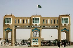 Chaman Gate border between Pakistan and Afghanistan | |
 Chaman  Chaman  Chaman  Chaman | |
| Coordinates: 30°55′20″N 66°26′41″E / 30.92222°N 66.44472°E | |
| Country | Pakistan |
| Province | Balochistan |
| District | Chaman District |
| Government | |
| • Malak | sayed mad khan |
| • malak | Lal khan |
| Elevation | 1,338 m (4,390 ft) |
| Population (2024 Census)[1] | |
| • Total | 800,000 |
| • Rank | 76th in Pakistan; 2nd largest city in Balochistan |
| Time zone | UTC+5 (PST) |
| Postal code | 86000 |
| Area code | 826 |
| Number of Union Councils | 13 |
Climate edit
With an influence from the local steppe climate, Chaman features a hot semi-arid climate (Köppen BSh). The average annual temperature in Chaman is 19.0 °C, while the annual precipitation averages 232 mm. June is the driest month with virtually no rain rainfall, while January is the wettest month, with an average 65 mm of precipitation.
July is the hottest month of the year with an average temperature of 31.0 °C. January is the coldest month with an average temperature of 6.4 °C.
| Climate data for Chaman | |||||||||||||
|---|---|---|---|---|---|---|---|---|---|---|---|---|---|
| Month | Jan | Feb | Mar | Apr | May | Jun | Jul | Aug | Sep | Oct | Nov | Dec | Year |
| Mean daily maximum °C (°F) | 13.3 (55.9) |
16.0 (60.8) |
21.2 (70.2) |
27.3 (81.1) |
33.8 (92.8) |
38.7 (101.7) |
39.3 (102.7) |
38.5 (101.3) |
35.2 (95.4) |
29.2 (84.6) |
21.1 (70.0) |
16.8 (62.2) |
27.5 (81.6) |
| Daily mean °C (°F) | 6.4 (43.5) |
9.0 (48.2) |
13.8 (56.8) |
19.5 (67.1) |
24.7 (76.5) |
29.1 (84.4) |
31.0 (87.8) |
29.6 (85.3) |
24.9 (76.8) |
18.9 (66.0) |
12.8 (55.0) |
8.5 (47.3) |
19.0 (66.2) |
| Mean daily minimum °C (°F) | −0.4 (31.3) |
2.1 (35.8) |
6.5 (43.7) |
11.7 (53.1) |
15.6 (60.1) |
19.5 (67.1) |
22.7 (72.9) |
20.7 (69.3) |
14.7 (58.5) |
8.7 (47.7) |
3.6 (38.5) |
0.3 (32.5) |
10.5 (50.9) |
| Source: Climate-Data.org[2] | |||||||||||||
Demography edit
| Religious group |
1941[3]: 13–14 | 2017[4][5] | ||||
|---|---|---|---|---|---|---|
| Pop. | % | Pop. | % | |||
| Hinduism |
2,898 | 43.58% | 379 | 0.31% | ||
| Islam |
2,812 | 42.29% | 122,263 | 99.23% | ||
| Sikhism |
697 | 10.48% | — | — | ||
| Christianity |
242 | 3.64% | 515 | 0.42% | ||
| Jainism |
1 | 0.02% | — | — | 49 | 0.04% |
| Total population | 0 | nan% | 800,000 | 100% | ||
Transport edit
Chaman has a railway station which accommodates services with Kandahar as well as other parts of Afghanistan. A slow passenger train runs between Chaman and Quetta daily. In 2008, it was proposed to extend this railway to Central Asia through Afghanistan. Chaman is on the Silk Road on the eastern side.
Trade edit
The town is an important trade point in the Balochistan region, providing a gateway on the trade routes between Afghanistan and Karachi. It underwent development during the martial law period of 1977 - 1985. People of the city import many things like cars, motor bikes and motor rickshaws. Besides, they import Japanese, Chinese and UAE phones, cosmetics, perfumes, and many other consumer goods from Afghanistan to Pakistan.[6]
Afghanistan War and terrorism edit
Chaman has been used by NATO forces as a major supply route into Afghanistan since 2000.[6]
On 30 August, 2009, an attack on a NATO convoy destroyed 20 fuel tankers and other supply trucks. The attackers reportedly fired rockets and small arms before destroying the trucks.[6][7]
Thousands of Afghan refugees enter Pakistan via the Chaman route on a regular basis.[8]
Bombings occurred in 2017, 2020 Chaman bombing, and 2021.[citation needed]
In December 2022, the Afghan Taliban forces launched indiscriminate fire at the Chaman border, twice in a week and caused civilian casualties on the Pakistani side.[citation needed]
Notable people edit
- Muhammad Essa, Former Pakistan International Footballer
- Asghar Khan Achakzai, President of the Awami National Party
Notes edit
References edit
- ^ "PAKISTAN: Provinces and Major Cities". PAKISTAN: Provinces and Major Cities. citypopulation.de website. Retrieved 19 July 2021.
- ^ "Climate: Chaman on Climate-Data.org website". Retrieved 19 July 2021.
- ^ a b "CENSUS OF INDIA, 1941 VOLUME XIV BALUCHISTAN". Retrieved 27 January 2023.
- ^ "Final Results (Census-2017)". Retrieved 27 January 2023.
- ^ "District Wise Results / Tables (Census - 2017) TABLE 9 - POPULATION BY SEX, RELIGION AND RURAL/URBAN" (PDF). Retrieved 27 January 2023.
- ^ a b c "Pakistan Blast Sets NATO Fuel Convoy Ablaze". Voice Of America News website. 31 August 2008. Archived from the original on 3 September 2009. Retrieved 19 July 2021.
- ^ "Boy killed as local traders, security personnel clash at Chaman border". The News International (newspaper). 30 November 2020. Retrieved 19 July 2021.
- ^ Mian Saifur Rehman. "Afghan refugees not being harassed". The News International (newspaper). Retrieved 19 July 2021.