


Summary
Chamarajanagar or Chamarajanagara is the southernmost district in the state of Karnataka, India. It was carved out of the original larger Mysore District in 1998. Chamarajanagar town is the headquarters of this district.[1]
Chamarajanagar District | |
|---|---|
| Chamarajanagara | |
     | |
| Nickname: Silk City | |
 Location in Karnataka | |
| Coordinates: 11°55′34″N 76°56′25″E / 11.9260°N 76.9402°E | |
| Country | |
| State | Karnataka |
| Established | 15 August 1997 |
| Headquarters | Chamarajanagar |
| Taluks | Kollegal, Yelandur, Gundlupet, Chamarajanagar, Hanur |
| Government | |
| • Deputy Commissioner | Shilpa Nag (IAS) |
| Area | |
| • Total | 5,101 km2 (1,970 sq mi) |
| Population (2011) | |
| • Total | 1,020,791 |
| • Density | 200/km2 (500/sq mi) |
| Languages | |
| • Official | Kannada |
| Time zone | UTC+5:30 (IST) |
| PIN | 571 313 |
| Telephone code | 08226 |
| ISO 3166 code | IN-KA |
| Vehicle registration |
|
| Website | chamrajnagar |

It is the third least populous district in Karnataka (out of 30), after Kodagu and Bangalore Rural.[2]
History edit
Chamarajanagar was earlier known as Sri Arikottara.[citation needed] Chamaraja Wodeyar, the Wodeyar of Mysuru was born here and hence this place was renamed after him. The Vijaya Parsvanath Basadi, a holy Jain shrine was constructed by Punisadandanayaka, the commander of the Hoysala king Gangaraja in the year 1117 AD.
Geography edit
Being the southernmost district of Karnataka, Chamarajanagar district borders the state of Tamil Nadu and Kerala. Specifically, it borders Mysore district of Karnataka to the west and north, Mandya and Ramanagara districts of Karnataka to the north-east, Dharmapuri and Krishnagiri districts of Tamil Nadu to the east, Salem to south-east, Erode districts and Nilgiris district of Tamil Nadu to the south, and to the extreme south-west, there is a very small border with Wayanad district of Kerala.
Most of the district lies in the leeward region of the Nilgiris and consists of mainly semi-arid rain-dependent flatlands along with forested hills.
Economy edit
The Karnataka state government has started a Rs.400 crore project on 1`,595 acres of land called Badanaguppe-Kellamballi Industrial Estate which will include sectors like automobile, food processing, textiles, leather, granite and agriculture related industries.
Many industries have set up base in the Badanaguppe-Kellamballi KIADB industrial estate. Notable ones are the KCM Appliances, Aditya Birla-Grasim Paint Plant, Kaynes Technology, Colortone Textiles among others.
Roads edit
Three national highways of India pass through Chamarajanagara district namely NH-766, NH-181, and NH-948. Some state highways of Karnataka pass through this district.
National Highway 948 ( previously NH 209), which starts from Bengaluru in Karnataka state and ends at Coimbatore in Tamil Nadu, passes through the following places namely Kanakapura, Malavalli, Kollegal, Chamarajanagar, Punajanur and enters Tamil Nadu.It further goes to Hasanur, Dhimbam ghat, Thalamalai, Bannari, Satyamangalam, Pullampatti, Annur ends at Coimbatore. Few KSRTC buses run on NH 948. There are many roads from Chamarajanagara district to neighbouring tamillunadu state. One road connects Kollegal to Hasanur via Dhondenling and Germalam. There is a Buddhist monastery at Dhondeling. Another road connects Kollegala to Anthiyur via Hanur, Ramapura, Burgur and Moongilpalya. The road from Kollegala to Mettur goes through Hanur Kowdalli( Cowdalli), Male Mahadeshwara Betta( MM Hills), Palar, Govindapadi, Kaveripuram and Kolathur. The above-mentioned three roads pass through forest teeming with wild animals, including elephants, Indian Bison, leopards and tigers. These roads are isolated and narrow at many stretches without any human habitation or cellular phone signals.
National Highway 181 connects Gundlupete town of Chamarajanagara district with Ooty via Bandipura and Gudalur. National Highway 766 connects Gundlupete with Kalpetta via Mulehole and Sulthan Bathery. The national highways 181 and 766 are closed for private vehicles at night in stretch between Gundlupete and neighbouring states.. Only state government buses are allowed at night in these section of highway.
Demographics edit
| Year | Pop. | ±% p.a. |
|---|---|---|
| 1901 | 334,676 | — |
| 1911 | 344,414 | +0.29% |
| 1921 | 328,501 | −0.47% |
| 1931 | 352,485 | +0.71% |
| 1941 | 390,337 | +1.03% |
| 1951 | 449,448 | +1.42% |
| 1961 | 533,759 | +1.73% |
| 1971 | 616,502 | +1.45% |
| 1981 | 768,198 | +2.22% |
| 1991 | 883,365 | +1.41% |
| 2001 | 965,462 | +0.89% |
| 2011 | 1,020,791 | +0.56% |
| source:[3] | ||
According to the 2011 census Chamarajanagar district has a population of 1,020,791,[2] roughly equal to the nation of Cyprus[5] or the US state of Montana.[6] This gives it a ranking of 441st in India (out of a total of 640).[2] The district has a population density of 200 inhabitants per square kilometre (520/sq mi) .[2] Its population growth rate over the decade 2001-2011 was 5.75%.[2] Chamarajanagar has a sex ratio of 989 females for every 1000 males,[2] and a literacy rate of 61.43%. 17.14% of the population lives in urban areas. Scheduled Castes and Scheduled Tribes make up 25.42% and 11.78% of the population respectively.[7]
The district has a high percentage of Scheduled Castes, with a population of 259,000, making up a quarter of the district's population. Having a large percentage of forest cover the district also has a high population of tribals, mostly the Nayakas but also forest tribes like the Soligas, Yeravas, Jenu Kurubas and Betta Kurubas. These tribals have their own languages and their total population is around 120,000, and make up 12% of the district population.[8] Other communities include Lingayats, Muslims and Vokkaligas.[9]
At the time of the 2011 census, 86.10% of the population spoke Kannada, 4.58% Tamil, 4.42% Urdu and 3.29% Telugu as their first language.[10]
Crime edit
Since much of the southern area of the district is dense forest, it provided good refuge to the notorious bandit Veerappan, responsible for the death of over a hundred policemen in both states of Karnataka and Tamil Nadu. He was shot dead in an encounter with the specially formed Special Task Force (STF) on 18 October 2004, in Dharmapuri district, Tamil Nadu. He had been on the run for over two decades. The presence of illegal quarrying for black stone imposes a great threat to the forests in the region.
Tourist attractions edit
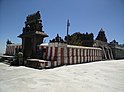
The main tourist attractions are Sri Chamarajeshwara temple in Chamarajanagar, Biligiriranga Hills, K Gudi, Male Mahadeshwara Hills, Gundal dam, Suvarnavati Dam, Hogenakal Falls, Shivasamudram, Bandipur national park, and Gopalaswamy Hills in Gundlupet.
Villages edit
Notable people edit
- Samsa - first historical playwright in Modern Kannada
- B. Rachaiah - politician
- B. S. Madhava Rao - mathematical physicist
- Nanjaiah Honganuru - noted folklorist and writer
- Mudnakudu Chinnaswamy - poet
- R. Dhruvanarayana - politician
- S. Mahendar - filmmaker
- Avinash - actor
- S.M. Siddaiah - lawyer and politician
- Srinivasa Prasad - politician
- veerappan - indian bandit and smuggler
References edit
- ^ "Archived copy". Archived from the original on 9 October 2011. Retrieved 12 October 2009.
{{cite web}}: CS1 maint: archived copy as title (link) - ^ a b c d e f "District Census Handbook: Chamarajanagar" (PDF). censusindia.gov.in. Registrar General and Census Commissioner of India. 2011.
- ^ Decadal Variation In Population Since 1901
- ^ "Table C-01 Population by Religion: Karnataka". censusindia.gov.in. Registrar General and Census Commissioner of India. 2011.
- ^ US Directorate of Intelligence. "Country Comparison:Population". Archived from the original on 13 June 2007. Retrieved 1 October 2011.
Cyprus 1,120,489 July 2011 est.
- ^ "2010 Resident Population Data". U. S. Census Bureau. Archived from the original on 19 October 2013. Retrieved 2011-09-30.
Montana 989,415
- ^ "Demography | Chamarajanagar District, Government of Karnataka | India".
- ^ "Chamarajanagar District Population Religion - Karnataka, Chamarajanagar Literacy, Sex Ratio - Census India". www.censusindia.co.in. Retrieved 21 April 2020.
- ^ "Lok Sabha Election 2019, Karnataka profile: Congress-JDS, BJP set for epic clash; Belgaum, Bangalore North, Shimoga key seats". Firstpost. 28 March 2019. Retrieved 21 April 2020.
- ^ a b "Table C-16 Population by Mother Tongue: Karnataka". www.censusindia.gov.in. Registrar General and Census Commissioner of India.
- ^ "12°11'59.8"N 77°08'55.1"E".
External links edit
- Official website
- Maps Of India - Map of Chamarajanagar district