


Summary
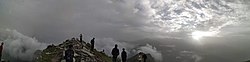
Chandrashila is the summit above Tungnath temple in India. It literally means "Moon Rock". It is located at a height of about 3,690 metres (12,110 ft) above sea level. This peak provides views of the Himalayas, including Nandadevi, Trisul, Kedar Peak, Bandarpunch and Chaukhamba peaks. There are various legends associated with this place. According to one such legend, this is where Lord Rama meditated after defeating the demon-king Ravana. Another legend says that the moon-god Chandra spent time here in penance.[1]
| Chandrashila | |
|---|---|
 | |
| Highest point | |
| Elevation | 3,690 m (12,110 ft)https://magpieecotourism.com/chopta/chopta-uttarakhand/ |
| Coordinates | 30°29′17″N 79°13′17″E / 30.48806°N 79.22139°E |
| Geography | |
 Chandrashila Location in northern India | |
| Location | Uttarakhand, India |
| Parent range | Garhwal Himalaya |


Accessibility edit
A bus can be directly taken up to Ukhimath from Haridwar or Dehradun or a taxi to Rudraprayag and then Ukhimath takes about 8 hours. There is no taxi service to Chopta from Ukhimath.
Chopta is well connected by motor roads with the major towns of Garhwal region of Uttarakhand state. Follow NH58 until you reach Rudraprayag and after reaching Rudraprayag follow the route to Kedarnath and take right turn to Ukhimath. Chopta is situated 29 km from Ukhimath. Chopta is also accessible from Gopeshwar.
The nearest railhead to Chopta is Rishikesh situated 209 km away. Rishikesh is well connected by railway networks with the major cities of India. Buses and taxis to Chopta and Ukhimath are easily available from Rishikesh.
Jolly Grant Airport is the nearest airport to Chopta, situated 226 km away in the Dehradun district of Uttarakhand state. The remaining journey has to be either by taxi or bus. Taxis are easily available to Rishikesh, Rudraprayag, Ukhimath and Chopta from Jolly Grant Airport.
Another possible route is through Haridwar to Rishikesh,[2] Rudraprayag then Ukhimath finally to Chopta.
Chopta distance chart edit
- Ukhimath to Chopta – 29 km
- Delhi to Chopta – 451 km
- Meerut to Chopta – 368 km
- Rishikesh to Chopta – 200 km
- Haridwar to Chopta – 225 km
- Pauri to Chopta – 126 km
- Dehradun to Chopta – 246 km
- Mussoorie to Chopta – 212 km
- Devprayag to Chopta – 130 km
- Tehri Garhwal to Chopta – 151 km
- Kotdwar to Chopta – 229 km
- Joshimath to Chopta – 92 km
- Srinagar to Chopta – 96 km

Chandrashila peak from Tungnath Temple - Kedarnath to Chopta – 64 km
- Rudraprayag to Chopta – 63 km
- Gopeshwar to Chopta – 41 km
- Badrinath to Chopta – 136 km

From Chopta it is a 6 km trek.
Trekking edit
Chandrashila treks are one of the most popular treks among Indian trekking enthusiasts. The trek to the peak is 5 km. The trek route that starts from Chopta takes one to Tungnath (highest Shiva temple in the world), from here it is a kilometre long, and a steep trek. Though shorter in distance, steep climbing makes this trek rigorous.
This trek is undertaken throughout the year although during the winter season due to snowfall this trek becomes hard as road to Chopta is closed. Trekkers use a different route during this period (Deoria Tal - Duggalbitta - Tungnath - Chandrashila).[3]

See also edit
References edit
- ^ "Chopta - Chopta Uttarakhand Hill Station Travel Guide 2021".
- ^ "Camping packages in Rishikesh - Riverside Resort - Rafting Package - Bungee Jumping Rishikesh". Simply H eaven Rishikesh. Retrieved 2 July 2021.
- ^ "Trek: Chandrashila Top, Camping and trekking in Himalayas". Archived from the original on 1 September 2009. Retrieved 2009-11-18.
External links edit
- Photos of Chandrashila