


Summary
The Chapel Island Formation is a sedimentary formation from the Burin Peninsula, Newfoundland, Canada. It is a succession of siliciclastic deposits, over 1,000 metres (3,300 ft) thick, that were deposited during the latest Ediacaran and earliest Cambrian.
| Chapel Island Formation | |
|---|---|
| Stratigraphic range: | |
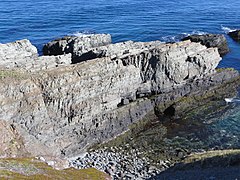 Ediacaran–Cambrian boundary section at Fortune Head, Newfoundland, in the Chapel Island Formation. The darker units constituting the bottom 2–3 m of the outcrop correspond to Unit 1; the GSSP lies a couple of meters into Unit 2. | |
| Type | Formation |
| Unit of | Young's Cove Group[2] |
| Underlies | Random Fm[3] |
| Overlies | Rencontre Fm[3] |
| Thickness | Hundreds of metres[3] |
| Location | |
| Region | Newfoundland |
| Country | Canada |
 Outcrop distribution in southeast Newfoundland | |
Stratigraphy edit
The formation's sequence stratigraphy is detailed in a journal article by Myrow and Hiscott.[4] The formation starts in an intertidal zone, then, as the Cambrian progresses, becomes deeper water (outer shelf) as a general trend.
The Chapel Island Formation lies on top of the Rencontre Formation and below the Random Formation.[1] It is 900 metres (3,000 ft) thick in Fortune Bay as a fault-bounded basin, consisting of grey-green siltstones and sandstones, with minor limestone beds near its top. Small shelly fossils have been recovered – primitive taxa only. The setting is nearshore or open shelf.[3]
Subdivisions edit
The formation is divided into six members, numbered 1 to 5, with Member 2 split into 2A and 2B. The Proterozoic–Cambrian boundary occurs 20.66 metres (67.8 ft) above the base of the formation, 2.4 metres (7.9 ft) into Member 2A.[1]
The lowest occurrence of Treptichnus pedum in the succession is 16.25 metres (53.3 ft) above the base of the unit.[1]
References edit
- ^ a b c d Gehling, James G.; Jensen, Sören; Droser, Mary L.; Myrow, Paul M.; Narbonne, Guy M. (2001). "Burrowing below the basal Cambrian GSSP, Fortune Head, Newfoundland" (PDF). Geological Magazine. 138 (2): 213–218. Bibcode:2001GeoM..138..213G. doi:10.1017/S001675680100509X. Archived from the original (PDF) on 28 October 2014. Retrieved 3 November 2012.
- ^ "Newfoundland and Labrador Geoscience Atlas".
- ^ a b c d Smith, Simon A.; Hiscott, Richard N. (December 1984). "Latest Precambrian to Early Cambrian basin evolution, Fortune Bay, Newfoundland: fault-bounded basin to platform". Canadian Journal of Earth Sciences. 21 (12): 1379–1392. Bibcode:1984CaJES..21.1379S. doi:10.1139/e84-143.
- ^ Myrow, Paul M.; Hiscott, Richard N. (September 1993). "Depositional history and sequence stratigraphy of the Precambrian-Cambrian boundary stratotype section, Chapel Island Formation, southeast Newfoundland". Palaeogeography, Palaeoclimatology, Palaeoecology. 104 (1–4): 13–35. doi:10.1016/0031-0182(93)90117-2.
Further reading edit
- An overview of the formation's sedimentology and facies is available in Narbonne, G. M., Myrow, P. M., Landing, E., and Anderson, M. M. (1987). A candidate stratotype for the Precambrian-Cambrian boundary, Fortune Head, Burin Peninsula, southeastern Newfoundland, Canadian Journal of Earth Sciences, 24, pp. 1277–1293.