


Summary
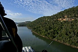
Cheero Point is a waterfront locality and suburb of the Central Coast region of New South Wales, Australia. Cheero Point is located on the west bank of the Mooney Mooney Creek in the Brisbane Water National Park. It is situated 53 kilometres (33 mi) north of Sydney. It is part of the Central Coast Council local government area.
| Cheero Point Central Coast, New South Wales | |||||||||||||||
|---|---|---|---|---|---|---|---|---|---|---|---|---|---|---|---|
 | |||||||||||||||
 Cheero Point | |||||||||||||||
 | |||||||||||||||
| Coordinates | 33°30′40″S 151°11′38″E / 33.511°S 151.194°E | ||||||||||||||
| Population | 87 (2016 census)[1] | ||||||||||||||
| Postcode(s) | 2083 | ||||||||||||||
| Elevation | 6 m (20 ft) | ||||||||||||||
| Location | |||||||||||||||
| LGA(s) | Central Coast Council | ||||||||||||||
| Parish | Cowan[2] | ||||||||||||||
| State electorate(s) | Gosford | ||||||||||||||
| Federal division(s) | Robertson | ||||||||||||||
| |||||||||||||||
History edit
The area was created by a land subdivision in 1918. In 1977, the Geographical Names Board included the small locality within the suburb of Mooney Mooney. However, community pressure from residents and the Mooney-Cheero Progress Association Inc. led to the old Gosford City Council recommending the separate gazettal of Cheero Point in its meeting on 5 November 2002, and the suburb name was officially reassigned on 21 March 2003.[3][4]
The suburb made headlines when landslides near Jolls Bridge forced the closure of a 250-metre section of the Pacific Highway for several years. By March 1990, only one lane remained open, and in April 1991 the highway was closed to traffic following investigations by the Roads and Traffic Authority. As the road was the only alternative route to the Pacific Motorway between Gosford and Sydney, which itself was prone to congestion, local service station owner Jim Lloyd collected 60,000 signatures demanding the re-opening of the road.[5] The cost of restoring the highway was estimated at A$2.3 million in May 1993.[6] The road was eventually re-opened in June 1994, and in the 1996 federal elections, Jim Lloyd was elected to represent the Division of Robertson within which Cheero Point is located.[7]
Geography edit
Cheero Point is bounded by the Pacific Motorway to the west, Mooney Mooney Creek to the east, and the southern boundary of the Brisbane Water National Park to the north. It is traversed by the Pacific Highway.[8]
Transport edit
There are approximately 65 buses each week departing from the corner of Cheero Point Rd and Cararma Pkwy.[9]
References edit
- ^ Australian Bureau of Statistics (27 June 2017). "Cheero Point (State Suburb)". 2016 Census QuickStats. Retrieved 10 November 2019.
- ^ "Cheero Point (Suburb)". Geographical Names Register (GNR) of NSW. Geographical Names Board of New South Wales. Retrieved 16 July 2007.
- ^ Burke, Nicolette (7 November 2002). "Independence Day - Residents put Cheero Point back on the map". The Daily Telegraph. p. 1.
- ^ "Geographical Names Act 1966 - Notice of Definition of a New Locality in Gosford City (per GNB3532)". New South Wales Government Gazette. 21 March 2003. p. 2003:4205.
- ^ "Pacific Highway (Cheero Point) Re-Opening Bill". Parliamentary Debates (Hansard). New South Wales Legislative Assembly. 1 April 1993. pp. 1121–1124. Archived from the original on 26 September 2007.
- ^ Dixon, Andrea (16 September 1993). "Pacific Highway to re-open". The Sydney Morning Herald. p. 2.
- ^ Allison, Col (3 October 1996). "MP battles F3 bottleneck". The Sydney Morning Herald. p. 3.
- ^ UBD (2005). Central Coast Street Directory (15 ed.). Universal Press. Map 104. ISBN 0-7319-1726-X.
- ^ "| transportnsw.info". transportnsw.info. Retrieved 3 November 2023.