


Summary
Cheltenham is a suburb in the Northern Sydney region of Sydney,[2] in the state of New South Wales, Australia. Cheltenham is 18 kilometres north-west of the Sydney central business district in the local government area of Hornsby Shire.
| Cheltenham Sydney, New South Wales | |||||||||||||||
|---|---|---|---|---|---|---|---|---|---|---|---|---|---|---|---|
 House opposite Cheltenham Station | |||||||||||||||
 | |||||||||||||||
| Population | 2,166 (2021 census)[1] | ||||||||||||||
| Postcode(s) | 2119 | ||||||||||||||
| Elevation | 119 m (390 ft) | ||||||||||||||
| Location | 18 km (11 mi) NW of Sydney CBD | ||||||||||||||
| LGA(s) | Hornsby Shire | ||||||||||||||
| Region | Northern Suburbs | ||||||||||||||
| State electorate(s) | Epping | ||||||||||||||
| Federal division(s) | Berowra | ||||||||||||||
| |||||||||||||||
Cheltenham is a small residential affluent suburb with a distinctive English atmosphere, characterised by a number of 19th century mansions on tree-lined streets. Cheltenham shares its postcode of 2119 with Beecroft and has sometimes been viewed as part of the suburb. Most residents of Cheltenham see themselves as distinct from Beecroft, although local issues are addressed together in the Beecroft Cheltenham Civic Trust.[citation needed]

History edit
Cheltenham takes its name from a house built by William Chorley, a Sydney tailor and men's outfitter, who acquired the land when it was released from the Field of Mars Reserve. He named the house after his birthplace of Cheltenham, Gloucestershire, England. Chorley asked the government to build a station here and to name it after his property when it opened in 1898. Sutherland Road was named for John Sutherland, Minister for Public Works from 1887 to 1889.[3]
Beecroft Cheltenham History Group edit

The Beecroft Cheltenham History Group was founded in 1987 by local history enthusiasts to record the history of Beecroft and Cheltenham and to collect and preserve photos and other historical information relative to the area. Since 2005 it has been part of the Beecroft Cheltenham Civic Trust.[4] In 1995 a book covering the history of Beecroft and Cheltenham up to 1914 was published.[5] In 2004 a book on walks around the district was published.[6] In 2005 a book about the Beecroft Children's Library was published.[7]
Heritage listings edit
Cheltenham has a number of heritage-listed sites, including:
Demographics edit
According to the 2021 census, there were 2,166 residents in Cheltenham.
- Ethnic diversity
- 64.2% of people were born in Australia. The next most common country of birth was China at 9.5% followed by Hong Kong with 3.6%, England with 3.0%, India with 2.3% and India with 1.7%. The most common ancestries in Cheltenham were English 27.2%, Australian 25.5%, Chinese 24.4%, Scottish 12.3% and Irish with 10.3%. 66.1% of people only spoke English at home. Other languages spoken at home included Mandarin 11.4%, Cantonese 7.2%, Tamil 1.4%, Korean 1.4%, Hindi 1.0%.
- Age distribution
- The average age of people in Cheltenham was 46, compared to the national median of 38. Children aged under 15 made up 16.6% of the population, and people aged 65 and over made up 19.3% of the population.
- Income
- Cheltenham is a wealthy suburb, with the median weekly household income being $3,573, more than double the national median weekly income of $1,746.[citation needed]
- Housing
- Nearly all of the dwellings in Cheltenham are made up of separate houses, being at 95.7%.[citation needed]
- Religion
- The most common responses for religion were No Religion 39.2%, Anglican 15.2%, Catholic 14.1%, Hinduism 4.1% and Buddhism 3.5%.[1]
Transport edit
Cheltenham railway station is on the Northern Line of the Sydney Trains network. It is one of the few stations with no surrounding business district, due to William Chorley placing covenants on the surrounding land.[citation needed]
The M2 Hills Motorway runs along the southern border of the suburb. For many years, Sutherland Road ran through both Beecroft and Cheltenham, and acted as a shortcut between Beecroft Road and Epping Road. This road ran to the east of the Railway line and, during peak hour, was quite busy. With the opening of the M2 Hills Motorway in 1997, Sutherland Road was closed at the Devlins Creek bridge - where the M2 enters a tunnel under North Epping. The result of this closure is that the areas east of the railway line are now very quiet, and the house values have benefitted.[citation needed]
-
 Cheltenham station from the bridge on Cheltenham Road
 -
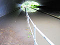 Devlins Creek, in flood under the M2, looking to Sutherland Road


Schools edit
Cheltenham Girls' High School, a government school, is located along Beecroft Road and The Promenade. Beecroft Public School and Arden Anglican School are primary schools in nearby Beecroft.[citation needed]
Commercial area edit
From its early days, Cheltenham was almost exclusively a residential suburb with no shopping area developed at all in its planning. Residents of Cheltenham often shop in Beecroft, Pennant Hills or Epping. The nearest shopping mall is in Carlingford.
Ahimsa edit
Ahimsa (an Indian word meaning non-violence) is the name of a bush retreat located in Cobran Road. It was originally the home of the environmentalist Marie Byles, who died in the house in 1979. It can be accessed at the rear of Day Road and Cobran Road (both roads are cul-de-sacs). The site is administered by the National Trust of Australia. The house is leased privately but the bush area is open to the public within certain restrictions.[9]
References edit
- ^ a b Australian Bureau of Statistics (28 June 2022). "Cheltenham (NSW)". 2021 Census QuickStats. Retrieved 28 February 2024.
- ^ "About Beecroft". Archived from the original on 10 April 2013.
- ^ The Book of Sydney Suburbs, Compiled by Frances Pollen, Angus & Robertson Publishers, 1990, Published in Australia ISBN 0-207-14495-8
- ^ "Beecroft and Cheltenham History Group". Beecroft Cheltenham History Group. Archived from the original on 28 February 2024. Retrieved 19 January 2020.
- ^ Beecroft-Cheltenham History Group (1995), Beecroft and Cheltenham : the shaping of a Sydney community to 1914, The Group, ISBN 978-0-646-24286-6
- ^ Barker, Helen; Goldberg, Lesley; Bartho, Catherine; Beecroft-Cheltenham History Group (2004), Beecroft and Cheltenham heritage walks, The Group, retrieved 19 January 2020
- ^ Dortins, Emma; Beecroft Cheltenham Civic Trust; Beecroft-Cheltenham History Group. Library Sub-Group (2005), Beecroft Children's Library : giving the gift of reading, 1942-1998, Beecroft Cheltenham Civic Trust, ISBN 978-0-9758343-0-5
- ^ "Ahimsa". New South Wales State Heritage Register. Department of Planning & Environment. H01494. Retrieved 18 May 2018.
 Text is licensed by State of New South Wales (Department of Planning and Environment) under CC-BY 4.0 licence.
- ^ National Trust Site Archived 13 November 2012 at the Wayback Machine
- Beecroft Cheltenham Civic Trust webpage
- Beecroft Cheltenham History Group Inc (1995). Beecroft and Cheltenham : The Shaping of a Sydney Community to 1914. The. ISBN 0-646-24286-5. (295 pages) [1][permanent dead link]
External links edit
- Joan Rowland (2008). "Cheltenham". Dictionary of Sydney. Retrieved 26 September 2015. [CC-By-SA]
- "Cheltenham NSW 2119 Northern Suburbs · Sydney Region". Domain. Archived from the original on 28 February 2024. Retrieved 28 February 2024.
33°45′30″S 151°04′32″E / 33.75839°S 151.07569°E