
KNOWPIA
WELCOME TO KNOWPIA

Cheverny 
Summary
Cheverny (French pronunciation: [ʃəvɛʁni]) is a commune in the French department of Loir-et-Cher, administrative region of Centre-Val de Loire.[3]
Cheverny | |
|---|---|
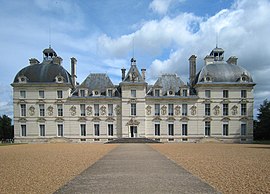 Château de Cheverny | |
 Coat of arms | |
Location of Cheverny .mw-parser-output .locmap .od{position:absolute}.mw-parser-output .locmap .id{position:absolute;line-height:0}.mw-parser-output .locmap .l0{font-size:0;position:absolute}.mw-parser-output .locmap .pv{line-height:110%;position:absolute;text-align:center}.mw-parser-output .locmap .pl{line-height:110%;position:absolute;top:-0.75em;text-align:right}.mw-parser-output .locmap .pr{line-height:110%;position:absolute;top:-0.75em;text-align:left}.mw-parser-output .locmap .pv>div{display:inline;padding:1px}.mw-parser-output .locmap .pl>div{display:inline;padding:1px;float:right}.mw-parser-output .locmap .pr>div{display:inline;padding:1px;float:left}html.skin-theme-clientpref-night .mw-parser-output .od,html.skin-theme-clientpref-night .mw-parser-output .od .pv>div,html.skin-theme-clientpref-night .mw-parser-output .od .pl>div,html.skin-theme-clientpref-night .mw-parser-output .od .pr>div{background:#000;color:#fff}html.skin-theme-clientpref-night .mw-parser-output .locmap{filter:grayscale(0.6)}@media(prefers-color-scheme:dark){html.skin-theme-clientpref-os .mw-parser-output .locmap{filter:grayscale(0.6)}html.skin-theme-clientpref-os .mw-parser-output .od,html.skin-theme-clientpref-os .mw-parser-output .od .pv>div,html.skin-theme-clientpref-os .mw-parser-output .od .pl>div,html.skin-theme-clientpref-os .mw-parser-output .od .pr>div{background:#000;color:#fff}}  Cheverny  Cheverny | |
| Coordinates: 47°30′00″N 1°27′40″E / 47.5°N 1.4611°E | |
| Country | France |
| Region | Centre-Val de Loire |
| Department | Loir-et-Cher |
| Arrondissement | Blois |
| Canton | Vineuil |
| Intercommunality | CA Blois Agglopolys |
| Government | |
| • Mayor (2020–2026) | Lionella Gallard[1] |
| Area 1 | 33 km2 (13 sq mi) |
| Population (2021)[2] | 908 |
| • Density | 28/km2 (71/sq mi) |
| Time zone | UTC+01:00 (CET) |
| • Summer (DST) | UTC+02:00 (CEST) |
| INSEE/Postal code | 41050 /41700 |
| Elevation | 78–116 m (256–381 ft) (avg. 85 m or 279 ft) |
| 1 French Land Register data, which excludes lakes, ponds, glaciers > 1 km2 (0.386 sq mi or 247 acres) and river estuaries. | |
It lies in the Loire Valley, about 10 km (6.2 mi) southeast of Blois.
Population edit
| Year | Pop. | ±% p.a. |
|---|---|---|
| 1968 | 743 | — |
| 1975 | 715 | −0.55% |
| 1982 | 842 | +2.36% |
| 1990 | 900 | +0.84% |
| 1999 | 986 | +1.02% |
| 2007 | 942 | −0.57% |
| 2012 | 975 | +0.69% |
| 2017 | 956 | −0.39% |
| Source: INSEE[4] | ||
Sights edit
The commune is the site of the Château de Cheverny, used by the Belgian comic book creator Hergé as a model for his fictional "Château de Moulinsart" (Marlinspike Hall in English) in the Adventures of Tintin books.
See also edit
References edit
- ^ "Répertoire national des élus: les maires". data.gouv.fr, Plateforme ouverte des données publiques françaises (in French). 2 December 2020.
- ^ "Populations légales 2021". The National Institute of Statistics and Economic Studies. 28 December 2023.
- ^ INSEE commune file
- ^ Population en historique depuis 1968, INSEE
Wikimedia Commons has media related to Cheverny.