


Summary
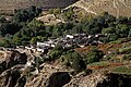
Chhusang (Thsug in Tibetan) is a village development committee in Mustang District in the Dhawalagiri Zone of northern Nepal. It is located on the Upper Mustang trekking route, between Tangbe and Chele, about an hour's walk north of Tangbe. It lies at the junction of the Narshing river and the Kali Gandaki.
Chhusang
छुसाङ | |
|---|---|
 Chhusang in the Kali Gandaki Gorge | |
 Chhusang Location in Nepal  Chhusang Chhusang (Nepal) | |
| Coordinates: 28°55′48″N 83°54′36″E / 28.93000°N 83.91000°E | |
| Country | |
| Zone | Dhawalagiri Zone |
| District | Mustang District |
| Population (1991) | |
| • Total | 860 |
| Time zone | UTC+5:45 (Nepal Time) |
It is surrounded by gigantic red, orange and silver gray cliffs spotted with cave dwellings. The village consists of three different hamlets: north of the Narshing river is Tangma, to the south of it is Braga, and west of Braga, towards the Kali Gandaki, is Cikyab.[1] It is an active farming community.
Demography edit
At the time of the 1991 Nepal census it had a population of 860 people living in 195 individual households.[2]
Religion and culture edit
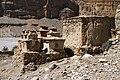
In the high cliffs on the west side of the Kali Gandhi river, is an extensive area of caves called Thagsing Grangma. To the south of these is an abandoned nunnery called Gompa Gang, the “Convent Ridge”.[3]
Galleries edit
-
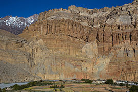 Chhusang cliffs.
 -
 Cave dwellings in the cliffs of Chhusang.
 -
 Natural caves at Chhusang.


- Villages of VDC Chhusang
-
 Chhusang
 -
 Kali Gandaki between Chhusang and Chele
 -
 Chele
Chele -
 From Chele to Samar
 -
 Samar
Samar -
 Ghyakar
 -
 Tangbe


References edit
- ^ Dead and living settlements in the Shöyul of Mustang (PDF)
- ^ "Nepal Census 2001", Nepal's Village Development Committees, Digital Himalaya, archived from the original on 12 October 2008, retrieved 15 November 2009.
- ^ Dead and living settlements in the Shöyul of Mustang (PDF)
External links edit
- UN map of the municipalities of Mustang District