


Summary
Choulou (Greek: Χούλου, Turkish: Hulu) is a village in the Paphos District of Cyprus, located 6 km (3.7 mi) west of Agios Fotios at an elevation of about 350 m (1,150 ft) above sea level. It is located in the centre of the district next to the village Lemona and near Statos-Agios Photios and Letymbou villages. Choulou is east of the Ezousa River and its tributary the Chalaras.[2]
Choulou
Χούλου | |
|---|---|
 St George fresco in Choulou | |
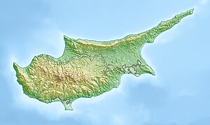 Choulou Location in Cyprus | |
| Coordinates: 34°52′16″N 32°33′27″E / 34.87111°N 32.55750°E | |
| Country | |
| District | Paphos District |
| Elevation | 1,106 ft (337 m) |
| Population (2001)[1] | |
| • Total | 190 |
| Time zone | UTC+2 (EET) |
| • Summer (DST) | UTC+3 (EEST) |
| Postal code | 6129 |
Ιn the period of Frankish rule in Cyprus Choulou was a small feudal town. In 1950 had a population of around 1,000 inhabitants. Today the population is around 150[3] and much of the village is abandoned.
Just outside the village is the Ammati forest. The traditional Cypriot tale 'Arodafnousa' born in Choulou.[clarification needed]
Choulou has five churches: Holy Cross, St Kononas, the Venetian church, St Theodoros, and the Byzantine church dedicated to St George. The village also has 2 taverns, 2 coffee shops, and one snack bar.