
KNOWPIA
WELCOME TO KNOWPIA

Ciry-le-Noble 
Summary
Ciry-le-Noble (French pronunciation: [siʁi lə nɔbl]) is a commune in the Saône-et-Loire department in the region of Bourgogne-Franche-Comté in eastern France.
Ciry-le-Noble | |
|---|---|
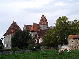 Chateau of Sauvement | |
Location of Ciry-le-Noble .mw-parser-output .locmap .od{position:absolute}.mw-parser-output .locmap .id{position:absolute;line-height:0}.mw-parser-output .locmap .l0{font-size:0;position:absolute}.mw-parser-output .locmap .pv{line-height:110%;position:absolute;text-align:center}.mw-parser-output .locmap .pl{line-height:110%;position:absolute;top:-0.75em;text-align:right}.mw-parser-output .locmap .pr{line-height:110%;position:absolute;top:-0.75em;text-align:left}.mw-parser-output .locmap .pv>div{display:inline;padding:1px}.mw-parser-output .locmap .pl>div{display:inline;padding:1px;float:right}.mw-parser-output .locmap .pr>div{display:inline;padding:1px;float:left}html.skin-theme-clientpref-night .mw-parser-output .od,html.skin-theme-clientpref-night .mw-parser-output .od .pv>div,html.skin-theme-clientpref-night .mw-parser-output .od .pl>div,html.skin-theme-clientpref-night .mw-parser-output .od .pr>div{background:#000;color:#fff}html.skin-theme-clientpref-night .mw-parser-output .locmap{filter:grayscale(0.6)}@media(prefers-color-scheme:dark){html.skin-theme-clientpref-os .mw-parser-output .locmap{filter:grayscale(0.6)}html.skin-theme-clientpref-os .mw-parser-output .od,html.skin-theme-clientpref-os .mw-parser-output .od .pv>div,html.skin-theme-clientpref-os .mw-parser-output .od .pl>div,html.skin-theme-clientpref-os .mw-parser-output .od .pr>div{background:#000;color:#fff}}  Ciry-le-Noble  Ciry-le-Noble | |
| Coordinates: 46°36′21″N 4°18′04″E / 46.6058°N 4.3011°E | |
| Country | France |
| Region | Bourgogne-Franche-Comté |
| Department | Saône-et-Loire |
| Arrondissement | Autun |
| Canton | Saint-Vallier |
| Intercommunality | CU Creusot Montceau |
| Area 1 | 33.07 km2 (12.77 sq mi) |
| Population (2021)[1] | 2,248 |
| • Density | 68/km2 (180/sq mi) |
| Time zone | UTC+01:00 (CET) |
| • Summer (DST) | UTC+02:00 (CEST) |
| INSEE/Postal code | 71132 /71420 |
| Elevation | 262–422 m (860–1,385 ft) (avg. 270 m or 890 ft) |
| 1 French Land Register data, which excludes lakes, ponds, glaciers > 1 km2 (0.386 sq mi or 247 acres) and river estuaries. | |
Geography edit
The Bourbince flows southwest through the middle of the commune and crosses the village.
Population edit
| Year | Pop. | ±% p.a. |
|---|---|---|
| 1968 | 3,166 | — |
| 1975 | 2,994 | −0.79% |
| 1982 | 2,915 | −0.38% |
| 1990 | 2,795 | −0.52% |
| 1999 | 2,475 | −1.34% |
| 2007 | 2,411 | −0.33% |
| 2012 | 2,348 | −0.53% |
| 2017 | 2,275 | −0.63% |
| Source: INSEE[2] | ||
See also edit
References edit
- ^ "Populations légales 2021". The National Institute of Statistics and Economic Studies. 28 December 2023.
- ^ Population en historique depuis 1968, INSEE
Wikimedia Commons has media related to Ciry-le-Noble.