


Summary
Cisco is a ghost town in Grand County, Utah, United States near the junction of State Route 128 (SR‑128) and Interstate 70 (I‑70).
Cisco, Utah | |
|---|---|
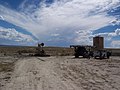
 Buildings in Cisco | |
 Cisco Location within the state of Utah  Cisco Cisco (the United States) | |
| Coordinates: 38°58′12″N 109°19′14″W / 38.97000°N 109.32056°W | |
| Country | United States |
| State | Utah |
| County | Grand |
| Population (2020) | |
| • Total | 4 |
| • Estimate (2019) | 1[1] |
| Time zone | UTC-7 (Mountain (MST)) |
| • Summer (DST) | UTC-6 (MDT) |
History edit
The town started in the 1880s as a saloon and water-refilling station for the Denver and Rio Grande Western Railroad. As work crews and, later, travelers came through, stores, hotels and restaurants sprang up to accommodate them. Nearby cattle ranchers and sheep herders in the Book Cliffs north of town began using Cisco as a livestock and provisioning center. Around the turn of the 20th century sheep were sheared at Cisco before being shipped to market. After oil and natural gas were discovered, Cisco continued to grow. The town's decline coincided with the demise of the steam locomotive. Cisco's already declining economy crashed when Interstate 70 was built, bypassing Cisco.[2]
The town site contains many relics of a typical old west railroad town. Cisco survived long enough into the 20th century to be assigned a ZIP Code, 84515.[3] The ghost town's easy access and proximity to the freeway have lured vandals, heavily damaging the historical artifacts. While Cisco had no permanent residents for many years, there are many known shale oil deposits around Cisco, and efforts have been made over the years to extract this shale leading to the town having a few migrant residents working for the oil drilling firms involved.
The town was also used in filming the opening and ending scenes of the 1971 cult classic movie Vanishing Point.
Mining edit
Oil and natural gas were discovered near Cisco in 1924. In 2005, new oil and gas wells were drilled in the nearby Cisco Oil Field by a Reno, Nevada-based company.[4] Newly drilled wells can be seen next to the railroad track and around the freeway. Cisco Mayor Dan Vanover was also an oil and turquoise miner from 1963 until his death in 1986. [citation needed]
Transportation edit
Cisco is along the former routing of US-6/US-50. The town was bypassed with the completion of I‑70 through the area but is still accessible by way of Exit 204. Cisco is listed as a control city for SR‑128, although the highway does not enter Cisco.[citation needed] Cisco is still served by the Union Pacific Railroad where a rail siding remains in use. The California Zephyr passenger train passes through Cisco, but is not a scheduled stop. During the summer months, whitewater river rafters use Cisco as a landing site, particularly for a trip through Westwater Canyon. The Kokopelli mountain bike Trail passes through Cisco.[5]
Gallery edit
-
 Oil wells in Cisco
 -
 Cisco oil field
 -
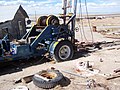 Cisco Yellow House with 1932 rig
 -
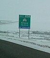 Exit sign on westbound Interstate 70


Climate edit
According to the Köppen Climate Classification system, Cisco has a semi-arid climate, abbreviated "BSk" on climate maps.[6]
See also edit
- Daqiu Island village, another ghost town with one modern inhabitant
References edit
- ^ "Home". eileenmuza.org.
- ^ Nancy Hazelet {thanks to A.J. Rogers}. "Cisco - Utah Ghost Town". Atjeu LLC. Retrieved 22 Jan 2008.
- ^ http://zip4.usps.com/zip4/citytown_zip.jsp USPS Zip Code locator
- ^ Pacific Energy and Mining Cisco Project
- ^ "Kokopelli Trail". blm.gov. Bureau of Land Management. 15 Apr 2016. Archived from the original on 20 August 2016. Retrieved 8 Aug 2016.
- ^ "Cisco, Utah Köppen Climate Classification (Weatherbase)". Retrieved 8 Aug 2016.