
KNOWPIA
WELCOME TO KNOWPIA

Claira 
Summary
Claira (French pronunciation: [klɛʁa] ⓘ; Catalan: Clairà) is a commune in the Pyrénées-Orientales department in southern France.[3]
Claira
Clairà | |
|---|---|
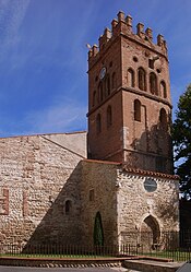 The church of Saint-Vincent, in Claira | |
 Coat of arms | |
Location of Claira .mw-parser-output .locmap .od{position:absolute}.mw-parser-output .locmap .id{position:absolute;line-height:0}.mw-parser-output .locmap .l0{font-size:0;position:absolute}.mw-parser-output .locmap .pv{line-height:110%;position:absolute;text-align:center}.mw-parser-output .locmap .pl{line-height:110%;position:absolute;top:-0.75em;text-align:right}.mw-parser-output .locmap .pr{line-height:110%;position:absolute;top:-0.75em;text-align:left}.mw-parser-output .locmap .pv>div{display:inline;padding:1px}.mw-parser-output .locmap .pl>div{display:inline;padding:1px;float:right}.mw-parser-output .locmap .pr>div{display:inline;padding:1px;float:left}html.skin-theme-clientpref-night .mw-parser-output .od,html.skin-theme-clientpref-night .mw-parser-output .od .pv>div,html.skin-theme-clientpref-night .mw-parser-output .od .pl>div,html.skin-theme-clientpref-night .mw-parser-output .od .pr>div{background:#000;color:#fff}html.skin-theme-clientpref-night .mw-parser-output .locmap{filter:grayscale(0.6)}@media(prefers-color-scheme:dark){html.skin-theme-clientpref-os .mw-parser-output .locmap{filter:grayscale(0.6)}html.skin-theme-clientpref-os .mw-parser-output .od,html.skin-theme-clientpref-os .mw-parser-output .od .pv>div,html.skin-theme-clientpref-os .mw-parser-output .od .pl>div,html.skin-theme-clientpref-os .mw-parser-output .od .pr>div{background:#000;color:#fff}}  Claira  Claira | |
| Coordinates: 42°45′40″N 2°57′22″E / 42.7611°N 2.9561°E | |
| Country | France |
| Region | Occitania |
| Department | Pyrénées-Orientales |
| Arrondissement | Perpignan |
| Canton | La Côte Salanquaise |
| Intercommunality | Corbières Salanque Méditerranée |
| Government | |
| • Mayor (2020–2026) | Marc Petit[1] |
| Area 1 | 19.34 km2 (7.47 sq mi) |
| Population (2021)[2] | 4,681 |
| • Density | 240/km2 (630/sq mi) |
| Time zone | UTC+01:00 (CET) |
| • Summer (DST) | UTC+02:00 (CEST) |
| INSEE/Postal code | 66050 /66530 |
| Elevation | 5–20 m (16–66 ft) (avg. 10 m or 33 ft) |
| 1 French Land Register data, which excludes lakes, ponds, glaciers > 1 km2 (0.386 sq mi or 247 acres) and river estuaries. | |
Geography edit
Claira is located in the canton of La Côte Salanquaise and in the arrondissement of Perpignan.

Claira is located 5 km from Perpignan.
Population edit
| Year | Pop. | ±% p.a. |
|---|---|---|
| 1968 | 1,446 | — |
| 1975 | 1,249 | −2.07% |
| 1982 | 1,415 | +1.80% |
| 1990 | 2,117 | +5.16% |
| 1999 | 2,625 | +2.42% |
| 2007 | 3,469 | +3.55% |
| 2012 | 3,756 | +1.60% |
| 2017 | 4,181 | +2.17% |
| Source: INSEE[4] | ||
See also edit
References edit
- ^ "Répertoire national des élus: les maires" (in French). data.gouv.fr, Plateforme ouverte des données publiques françaises. 13 September 2022.
- ^ "Populations légales 2021". The National Institute of Statistics and Economic Studies. 28 December 2023.
- ^ INSEE commune file
- ^ Population en historique depuis 1968, INSEE
External links edit
 Media related to Claira at Wikimedia Commons
- Histoire du Roussillon (French)