
KNOWPIA
WELCOME TO KNOWPIA

Clais 
Summary
Clais (French pronunciation: [klɛ]) is a commune in the Seine-Maritime department in the Normandy region in northern France.
Clais | |
|---|---|
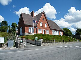 The town hall and school in Clais | |
Location of Clais .mw-parser-output .locmap .od{position:absolute}.mw-parser-output .locmap .id{position:absolute;line-height:0}.mw-parser-output .locmap .l0{font-size:0;position:absolute}.mw-parser-output .locmap .pv{line-height:110%;position:absolute;text-align:center}.mw-parser-output .locmap .pl{line-height:110%;position:absolute;top:-0.75em;text-align:right}.mw-parser-output .locmap .pr{line-height:110%;position:absolute;top:-0.75em;text-align:left}.mw-parser-output .locmap .pv>div{display:inline;padding:1px}.mw-parser-output .locmap .pl>div{display:inline;padding:1px;float:right}.mw-parser-output .locmap .pr>div{display:inline;padding:1px;float:left}html.skin-theme-clientpref-night .mw-parser-output .od,html.skin-theme-clientpref-night .mw-parser-output .od .pv>div,html.skin-theme-clientpref-night .mw-parser-output .od .pl>div,html.skin-theme-clientpref-night .mw-parser-output .od .pr>div{background:#000;color:#fff}html.skin-theme-clientpref-night .mw-parser-output .locmap{filter:grayscale(0.6)}@media(prefers-color-scheme:dark){html.skin-theme-clientpref-os .mw-parser-output .locmap{filter:grayscale(0.6)}html.skin-theme-clientpref-os .mw-parser-output .od,html.skin-theme-clientpref-os .mw-parser-output .od .pv>div,html.skin-theme-clientpref-os .mw-parser-output .od .pl>div,html.skin-theme-clientpref-os .mw-parser-output .od .pr>div{background:#000;color:#fff}}  Clais  Clais | |
| Coordinates: 49°48′31″N 1°27′01″E / 49.8086°N 1.4503°E | |
| Country | France |
| Region | Normandy |
| Department | Seine-Maritime |
| Arrondissement | Dieppe |
| Canton | Neufchâtel-en-Bray |
| Intercommunality | CC Londinières |
| Government | |
| • Mayor (2020–2026) | Vincent Leborgne[1] |
| Area 1 | 12.45 km2 (4.81 sq mi) |
| Population (2021)[2] | 262 |
| • Density | 21/km2 (55/sq mi) |
| Time zone | UTC+01:00 (CET) |
| • Summer (DST) | UTC+02:00 (CEST) |
| INSEE/Postal code | 76175 /76660 |
| Elevation | 86–224 m (282–735 ft) (avg. 98 m or 322 ft) |
| 1 French Land Register data, which excludes lakes, ponds, glaciers > 1 km2 (0.386 sq mi or 247 acres) and river estuaries. | |
Geography edit
A farming village situated by the banks of the river Eaulne in the Pays de Bray, some 24 miles (39 km) southeast of Dieppe, at the junction of the D1314 and the D14 roads.
Population edit
| Year | Pop. | ±% p.a. |
|---|---|---|
| 1968 | 289 | — |
| 1975 | 259 | −1.55% |
| 1982 | 244 | −0.85% |
| 1990 | 209 | −1.92% |
| 1999 | 202 | −0.38% |
| 2007 | 207 | +0.31% |
| 2012 | 237 | +2.74% |
| 2017 | 259 | +1.79% |
| Source: INSEE[3] | ||
Places of interest edit
- The church of St.Martin, dating from the eleventh century.
See also edit
References edit
- ^ "Répertoire national des élus: les maires" (in French). data.gouv.fr, Plateforme ouverte des données publiques françaises. 13 September 2022.
- ^ "Populations légales 2021". The National Institute of Statistics and Economic Studies. 28 December 2023.
- ^ Population en historique depuis 1968, INSEE
External links edit
Wikimedia Commons has media related to Clais.
- Clais on the Quid website (in French)