


Summary
Clarinda is a city in and the county seat of Page County, Iowa.[4] It is located in Nodaway Township. The population was 5,369 at the time of the 2020 census.[5]
Clarinda, Iowa | |
|---|---|
 | |
| Motto: "Honor the Past...Imagine the Future"[1] | |
 Location within Page County and Iowa | |
| Coordinates: 40°44′16″N 95°02′09″W / 40.73778°N 95.03583°W | |
| Country | |
| State | |
| County | Page |
| Area | |
| • Total | 5.13 sq mi (13.29 km2) |
| • Land | 5.10 sq mi (13.21 km2) |
| • Water | 0.03 sq mi (0.09 km2) |
| Elevation | 1,027 ft (313 m) |
| Population (2020) | |
| • Total | 5,369 |
| • Density | 1,052.75/sq mi (406.46/km2) |
| Time zone | UTC-6 (CST) |
| • Summer (DST) | UTC-5 (CDT) |
| ZIP code | 51632 |
| Area code | 712 |
| FIPS code | 19-13575 |
| GNIS ID | 2393534[3] |
| Website | bestiowatown.com |
History edit
Clarinda was founded in 1851, and incorporated on December 8, 1866. Many stories are told of such notables as Jesse James frequently passing through.
The town is named for Clarinda Buck, who according to legend carried water to the surveyors while Page County was first being surveyed.[6]
The best known national firm in Clarinda for many decades was Berry's Seed Company, a mail order farm seed distribution business founded in 1885 at Clarinda by A. A. Berry. Berry's Seed Company diversified into retail stores in the 1950s, but the stores were sold off over the following decade, and today the company, known as Berry's Garden Center, operates from its one remaining retail outlet in Danville, Illinois.[7]
In 1943, during World War II, an internment camp designed for 3,000 prisoners of war with sixty barracks and a 150-bed hospital was built in Clarinda. German prisoners were the first to arrive at Camp Clarinda, followed in 1945 by Italian and Japanese POWs.[8]
The southeast area of Clarinda was once dubbed "Gun Town" and remains known by that name today. A noted author wrote, "In the twenties and thirties, Clarinda seemed to be two separate towns: Guntown and Uptown. In the middle of the square was, and remains, the courthouse. The four blocks surrounding the square are filled with businesses. Guntown was a town all its own. The 700 block of East Garfield was a solid block of businesses--grocery stores, barber, a Chinese restaurant, another restaurant on a corner, a rug factory, a large grocery, the Swifts packing plant, and railroad tracks with freight depot and roundhouse to turn trains around."[9]
Transportation edit
Road Network
Clarinda is located on US Highway 71 and Iowa Highway 2. In the past, both of these highways came through the center of town, but there is now a bypass that takes both highways to the south and east of Clarinda proper. There is also a good network of “farm to market” or county roads servicing the area.[10]
Railroad Service
Early in its history, Clarinda was served by railroads from seven different directions - 5 of which were predecessors to the Chicago, Burlington, and Quincy Railroad (CB&Q). The short westbound leg of track connecting Clarinda to Shenandoah was torn up in 1936 due to a washout of the track. In 1946, service was lost on the eastbound leg to Humeston and the line southwest to Tarkio, Missouri, through Coin, Iowa. Service was maintained south of Clarinda until the 1950s and was then trimmed back to a branch serving Clarinda from the main line to the north at Villisca, Iowa. This line survived a merger into the Burlington Northern but was abandoned in the 1980s. The beautiful brick depot in Clarinda still survives and is now the Student Union of the Iowa Western Community College-Clarinda campus.
There were two additional shortline railroads that ran to Clarinda. One was the Iowa & Southwestern which connected Clarinda southwest through College Springs to the Iowa-Missouri border town of Blanchard. The I&SW had its own depot very close to the Clarinda CB&Q Depot. It was abandoned before 1914. The second route was the Clarinda and St. Louis Railroad which ran south out of Clarinda roughly paralleling the CB&Q line to the east and terminating in Rosenberry, Missouri. This line joined with the Wabash Railroad just a few miles east of the CB&Q line also from Clarinda interchanged with the Wabash in the town of Burlington Junction, Missouri. The Clarinda and St. Louis Railroad was abandoned in the 1899 after only a few years of operation.[11][12][13]
Clarinda now joins a growing list of county seats in Iowa without rail service.[12]
Air Service
Camp Clarinda was located by what today is the town's municipal airport, Schenck Field (named for aviator/farmer Ray Schenck, who built the original Clarinda Airport on the location).
Geography edit
Clarinda is located along the West Nodaway River, just north of its confluence with the East Nodaway River.
According to the United States Census Bureau, the city has a total area of 5.22 square miles (13.52 km2), of which 5.19 square miles (13.44 km2) is land and 0.03 square miles (0.08 km2) is water.[14]
Climate edit
| Climate data for Clarinda, Iowa (1991–2020, extremes 1893–present) | |||||||||||||
|---|---|---|---|---|---|---|---|---|---|---|---|---|---|
| Month | Jan | Feb | Mar | Apr | May | Jun | Jul | Aug | Sep | Oct | Nov | Dec | Year |
| Record high °F (°C) | 68 (20) |
80 (27) |
92 (33) |
96 (36) |
105 (41) |
105 (41) |
112 (44) |
114 (46) |
108 (42) |
94 (34) |
82 (28) |
72 (22) |
114 (46) |
| Mean maximum °F (°C) | 54.9 (12.7) |
60.7 (15.9) |
74.7 (23.7) |
84.5 (29.2) |
89.7 (32.1) |
92.5 (33.6) |
94.1 (34.5) |
93.4 (34.1) |
90.8 (32.7) |
85.5 (29.7) |
71.0 (21.7) |
59.1 (15.1) |
96.3 (35.7) |
| Mean daily maximum °F (°C) | 32.7 (0.4) |
37.7 (3.2) |
50.8 (10.4) |
62.9 (17.2) |
73.0 (22.8) |
82.3 (27.9) |
85.8 (29.9) |
84.1 (28.9) |
77.9 (25.5) |
65.7 (18.7) |
50.1 (10.1) |
37.6 (3.1) |
61.7 (16.5) |
| Daily mean °F (°C) | 22.3 (−5.4) |
27.1 (−2.7) |
39.1 (3.9) |
50.4 (10.2) |
61.7 (16.5) |
71.5 (21.9) |
75.0 (23.9) |
72.8 (22.7) |
64.9 (18.3) |
52.6 (11.4) |
38.6 (3.7) |
27.5 (−2.5) |
50.3 (10.2) |
| Mean daily minimum °F (°C) | 11.9 (−11.2) |
16.4 (−8.7) |
27.5 (−2.5) |
38.0 (3.3) |
50.3 (10.2) |
60.8 (16.0) |
64.1 (17.8) |
61.5 (16.4) |
51.8 (11.0) |
39.4 (4.1) |
27.1 (−2.7) |
17.4 (−8.1) |
38.9 (3.8) |
| Mean minimum °F (°C) | −10.6 (−23.7) |
−4.0 (−20.0) |
6.2 (−14.3) |
21.8 (−5.7) |
34.8 (1.6) |
47.4 (8.6) |
52.8 (11.6) |
50.4 (10.2) |
36.1 (2.3) |
22.9 (−5.1) |
10.5 (−11.9) |
−3.6 (−19.8) |
−14.8 (−26.0) |
| Record low °F (°C) | −31 (−35) |
−29 (−34) |
−24 (−31) |
6 (−14) |
21 (−6) |
36 (2) |
42 (6) |
36 (2) |
24 (−4) |
−1 (−18) |
−10 (−23) |
−27 (−33) |
−31 (−35) |
| Average precipitation inches (mm) | 0.79 (20) |
1.16 (29) |
2.22 (56) |
3.32 (84) |
5.60 (142) |
5.33 (135) |
4.77 (121) |
3.95 (100) |
3.30 (84) |
2.85 (72) |
1.98 (50) |
1.38 (35) |
36.65 (931) |
| Average snowfall inches (cm) | 6.5 (17) |
6.3 (16) |
2.7 (6.9) |
0.9 (2.3) |
0.0 (0.0) |
0.0 (0.0) |
0.0 (0.0) |
0.0 (0.0) |
0.0 (0.0) |
0.3 (0.76) |
1.8 (4.6) |
4.3 (11) |
22.8 (58) |
| Average precipitation days (≥ 0.01 in) | 5.3 | 6.0 | 7.7 | 10.7 | 13.0 | 10.9 | 9.7 | 8.9 | 7.6 | 8.3 | 6.3 | 5.7 | 100.1 |
| Average snowy days (≥ 0.1 in) | 3.6 | 3.6 | 1.5 | 0.3 | 0.0 | 0.0 | 0.0 | 0.0 | 0.0 | 0.2 | 1.1 | 3.1 | 13.4 |
| Source: NOAA[15][16] | |||||||||||||
Demographics edit
| Census | Pop. | Note | %± |
|---|---|---|---|
| 1860 | 427 | — | |
| 1870 | 1,022 | 139.3% | |
| 1880 | 2,011 | 96.8% | |
| 1890 | 3,262 | 62.2% | |
| 1900 | 3,276 | 0.4% | |
| 1910 | 3,832 | 17.0% | |
| 1920 | 4,511 | 17.7% | |
| 1930 | 4,962 | 10.0% | |
| 1940 | 4,905 | −1.1% | |
| 1950 | 5,086 | 3.7% | |
| 1960 | 5,901 | 16.0% | |
| 1970 | 5,420 | −8.2% | |
| 1980 | 5,458 | 0.7% | |
| 1990 | 5,104 | −6.5% | |
| 2000 | 5,690 | 11.5% | |
| 2010 | 5,572 | −2.1% | |
| 2020 | 5,369 | −3.6% | |
| U.S. Decennial Census[17][5] | |||

2010 census edit
As of the census[18] of 2010, there were 5,572 people, 1,928 households, and 1,153 families residing in the city. The population density was 1,073.6 inhabitants per square mile (414.5/km2). There were 2,180 housing units at an average density of 420.0 per square mile (162.2/km2). The racial makeup of the city was 89.2% White, 5.6% African American, 1.1% Native American, 1.5% Asian, 0.1% Pacific Islander, 0.8% from other races, and 1.7% from two or more races. Hispanic or Latino of any race were 3.2% of the population.
There were 1,928 households, of which 26.1% had children under the age of 18 living with them, 45.3% were married couples living together, 10.2% had a female householder with no husband present, 4.4% had a male householder with no wife present, and 40.2% were non-families. 35.3% of all households were made up of individuals, and 18% had someone living alone who was 65 years of age or older. The average household size was 2.19 and the average family size was 2.80.
The median age in the city was 40 years. 21.1% of residents were under the age of 18; 8.9% were between the ages of 18 and 24; 26.4% were from 25 to 44; 25.6% were from 45 to 64; and 18% were 65 years of age or older. The gender makeup of the city was 57.6% male and 42.4% female.
2000 census edit
As of the census[19] of 2000, there were 5,690 people, 2,017 households, and 1,246 families residing in the city. The population density was 1,096.1 inhabitants per square mile (423.2/km2). There were 2,188 housing units at an average density of 421.5 per square mile (162.7/km2). The racial makeup of the city was 92.02% White, 4.62% African American, 0.65% Native American, 1.09% Asian, 0.04% Pacific Islander, 0.51% from other races, and 1.07% from two or more races. Hispanic or Latino of any race were 1.41% of the population.
There were 2,017 households, out of which 27.5% had children under the age of 18 living with them, 49.4% were married couples living together, 9.8% had a female householder with no husband present, and 38.2% were non-families. 34.7% of all households were made up of individuals, and 18.0% had someone living alone who was 65 years of age or older. The average household size was 2.21 and the average family size was 2.83.
Age spread: 22.1% under the age of 18, 9.3% from 18 to 24, 29.8% from 25 to 44, 19.5% from 45 to 64, and 19.3% who were 65 years of age or older. The median age was 38 years. For every 100 females, there were 121.7 males. For every 100 females age 18 and over, there were 122.2 males.
The median income for a household in the city was $35,871, and the median income for a family was $43,654. Males had a median income of $35,061 versus $23,635 for females. The per capita income for the city was $15,136. About 9.9% of families and 16.3% of the population were below the poverty line, including 18.2% of those under age 18 and 6.6% of those age 65 or over.
Economy edit
NSK-AKS (a subsidiary of the Japanese corporation NSK Ltd.) operates a manufacturing plant in Clarinda that produces ball and roller bearings.[20][21]
Lisle Corporation, which makes hand tools and garage creepers for auto mechanics, was founded in Clarinda in 1903.
A large mental health center, the Clarinda Treatment Complex, is located on the north edge of the city. It was established in 1884 as the third mental asylum in the state of Iowa. Mental health professionals treated sex offenders, the mentally ill, alcoholics, drug addicts, and the criminally insane until its closing in 2015.
Sports edit
Clarinda is the home of the Clarinda A's, a summer amateur baseball team, founded by Merl Eberly. The team won the 1981 National Baseball Congress championship. It has sent several players on to the major leagues, notably Baseball Hall of Fame member Ozzie Smith, who regularly returns to Clarinda for special events. Previously, Clarinda was home to minor league baseball. The 1910-1911 Clarinda Antelopes played as members of the Class D level Missouri-Iowa-Nebraska-Kansas League.[22]
Iowa Western Community College fielded Nationally Ranked junior college baseball teams from 1982 through 1984. Compiling a record of 119 wins and 26 losses during that time, the IWCC Bluejays were nationally ranked as high as 9th in the nation in 1982, ranked 4th in 1983 and the 1984 team was ranked 6th nationally and went to the National Junior College World Series in Grand Junction, Colorado. Coach Jeff DuPre's teams had a total of 10 players drafted during the three-year span and had players continue their college careers at schools such has Arizona State, Nebraska, Illinois, South Alabama, Jacksonville, Louisiana Tech, Grand Canyon State and South Carolina/Aiken. The 1982 to 1984 span also produced 6 All-American players, with George Gonzalez being First Team All American in 1982. The 1982 team set a Junior College record at the time with a .390 batting average. When the IWCC Bluejays went to the 1984 NJCAA World Series they were the smallest school ever to qualify.[citation needed]
Clarinda picture gallery edit
-
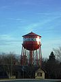 Clarinda water tower
 -
 Clarinda welcome sign
 -
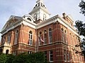 Page County, Iowa Courthouse in Clarinda
 -
 Snowing in Clarinda (December 2009)


Education edit
The Clarinda Community School District serves the municipality.[23]
Clarinda is also home to a campus of Iowa Western Community College
Infrastructure edit
Health care edit
In 1884, the citizens rallied to build the third mental hospital in the state of Iowa. For over 100 years, the Clarinda State Hospital, known as the Clarinda Treatment Complex, was located on the north end of the city. On June 30, 2015, the hospital facility was shut down and all patient services terminated.[24] The Clarinda Academy, a juvenile detention facility owned by Sequel Youth Services, was the sole occupant of the former hospital grounds until its closure in 2021.
In 1939, the Clarinda Municipal Hospital was created. In 1997, Clarinda Municipal Hospital's name was changed by its Board of Trustees to Clarinda Regional Health Center. In January 2012, the Clarinda Regional Health Center (CRHC) moved into a new replacement hospital and clinic facility on the south edge of Clarinda. CRHC is a municipal, non-profit, Critical Access Hospital licensed for 25 in-patient beds.
State prison edit
Clarinda also holds a state prison called the Clarinda Correctional Facility.[25]
Transportation edit
Daily intercity bus service to Clarinda is provided by Jefferson Lines. The bus stop serves buses between Sioux Falls and Kansas City.
Notable people edit
- Vernon Baker, one of seven African-American World War II Medal of Honor recipients
- Edwin Harris Colbert, paleontologist
- William Peters Hepburn, U.S. representative
- Norman Maclean, author of A River Runs Through It
- Marilyn Maxwell, singer and film actress
- Glenn Miller, 1940s big band leader
- Jessie Field Shambaugh, founder of 4-H
References edit
- ^ "City of Clarinda, Iowa". City of Clarinda, Iowa. Retrieved September 2, 2012.
- ^ "2020 U.S. Gazetteer Files". United States Census Bureau. Retrieved March 16, 2022.
- ^ a b U.S. Geological Survey Geographic Names Information System: Clarinda, Iowa
- ^ "Find a County". National Association of Counties. Archived from the original on May 31, 2011. Retrieved June 7, 2011.
- ^ a b "2020 Census State Redistricting Data". census.gov. United states Census Bureau. Retrieved August 12, 2021.
- ^ "Page County". Archived from the original on May 8, 2009. Retrieved February 13, 2009.
- ^ "Berry's Garden Center - Home". www.berrysgarden.com. Retrieved April 5, 2023.
- ^ Sullivan, Ken. - "POW camps - Thousands of German prisoners held during war in Iowa, Midwest". - The Gazette. - December 16, 2001. | - Kilen, Mike. - "When War Marched Into Iowa". - Des Moines Register. - September 23, 2007.
- ^ Juanita Seeley. "Gun Town, My Hometown."
- ^ Rand McNally 2020 Road Atlas, p.38, copyright 2019
- ^ Corbin, Bernard G and Hardy, Joseph C.; Across Iowa on the Keokuk & Western and the Humeston & Shenandoah Railroads,; p. 125; Copyright 1986 by Corbin Publications
- ^ State of Iowa, Iowa Department of Transportation, Chronology of Iowa Railroad Abandonments, July 1, 2016
- ^ Walker, Mike; SPV's Comprehensive Railroad Atlas of North America, Prairies East and Ozarks, 2004 p.23
- ^ "US Gazetteer files 2010". United States Census Bureau. Archived from the original on January 25, 2012. Retrieved May 11, 2012.
- ^ "NowData – NOAA Online Weather Data". National Oceanic and Atmospheric Administration. Retrieved November 27, 2021.
- ^ "Station: Clarinda, IA". U.S. Climate Normals 2020: U.S. Monthly Climate Normals (1991-2020). National Oceanic and Atmospheric Administration. Retrieved November 27, 2021.
- ^ "Census of Population and Housing". Census.gov. Retrieved June 4, 2015.
- ^ "U.S. Census website". United States Census Bureau. Retrieved May 11, 2012.
- ^ "U.S. Census website". United States Census Bureau. Retrieved January 31, 2008.
- ^ NSK Corporation U.S. Facilities[permanent dead link]. - NSK Ltd.
- ^ Ford, George C. - "U.S., Japanese firms share need for skilled, educated work force". The Gazette. - September 25, 1994.
- ^ Gray, Rob. - "Smith remembers days as `Osborne' in Clarinda". - Des Moines Register. - January 20, 2002. | - Clark, Bill. - "Town proves baseball still is America's game". - Columbia Daily Tribune. - January 14, 2009.
- ^ "Clarinda Archived 2018-04-27 at the Wayback Machine." Iowa Department of Education. Retrieved on July 20, 2018.
- ^ "Clarinda State Hospital - Kirkbride Buildings". www.kirkbridebuildings.com.
- ^ "Iowa Department of Corrections - Institution Descriptions". www.doc.state.ia.us. Archived from the original on February 26, 2015. Retrieved January 22, 2017.
External links edit
- City of Clarinda, Iowa Website Portal style website, Government, Business, Library, Recreation and more
- Clarinda Chamber of Commerce
- Clarinda Economic Development Corporation Archived January 29, 2004, at the Wayback Machine