
KNOWPIA
WELCOME TO KNOWPIA

Clayes 
Summary
Clayes (French pronunciation: [klɛ]; Occitan: Kloued; Gallo: Claès) is a commune in the Ille-et-Vilaine department in Brittany in northwestern France.
Clayes
| |
|---|---|
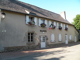 Town hall | |
 Coat of arms | |
Location of Clayes .mw-parser-output .locmap .od{position:absolute}.mw-parser-output .locmap .id{position:absolute;line-height:0}.mw-parser-output .locmap .l0{font-size:0;position:absolute}.mw-parser-output .locmap .pv{line-height:110%;position:absolute;text-align:center}.mw-parser-output .locmap .pl{line-height:110%;position:absolute;top:-0.75em;text-align:right}.mw-parser-output .locmap .pr{line-height:110%;position:absolute;top:-0.75em;text-align:left}.mw-parser-output .locmap .pv>div{display:inline;padding:1px}.mw-parser-output .locmap .pl>div{display:inline;padding:1px;float:right}.mw-parser-output .locmap .pr>div{display:inline;padding:1px;float:left}html.skin-theme-clientpref-night .mw-parser-output .od,html.skin-theme-clientpref-night .mw-parser-output .od .pv>div,html.skin-theme-clientpref-night .mw-parser-output .od .pl>div,html.skin-theme-clientpref-night .mw-parser-output .od .pr>div{background:#000;color:#fff}html.skin-theme-clientpref-night .mw-parser-output .locmap{filter:grayscale(0.6)}@media(prefers-color-scheme:dark){html.skin-theme-clientpref-os .mw-parser-output .locmap{filter:grayscale(0.6)}html.skin-theme-clientpref-os .mw-parser-output .od,html.skin-theme-clientpref-os .mw-parser-output .od .pv>div,html.skin-theme-clientpref-os .mw-parser-output .od .pl>div,html.skin-theme-clientpref-os .mw-parser-output .od .pr>div{background:#000;color:#fff}}  Clayes  Clayes | |
| Coordinates: 48°10′39″N 1°51′05″W / 48.1775°N 1.8514°W | |
| Country | France |
| Region | Brittany |
| Department | Ille-et-Vilaine |
| Arrondissement | Rennes |
| Canton | Melesse |
| Intercommunality | Rennes Métropole |
| Government | |
| • Mayor (2020–2026) | Philippe Sicot[1] |
| Area 1 | 4.28 km2 (1.65 sq mi) |
| Population (2021)[2] | 937 |
| • Density | 220/km2 (570/sq mi) |
| Time zone | UTC+01:00 (CET) |
| • Summer (DST) | UTC+02:00 (CEST) |
| INSEE/Postal code | 35081 /35590 |
| Elevation | 65–109 m (213–358 ft) |
| 1 French Land Register data, which excludes lakes, ponds, glaciers > 1 km2 (0.386 sq mi or 247 acres) and river estuaries. | |
Population edit
Inhabitants of Clayes are called Clayens in French.
| Year | Pop. | ±% |
|---|---|---|
| 1962 | 190 | — |
| 1968 | 178 | −6.3% |
| 1975 | 256 | +43.8% |
| 1982 | 403 | +57.4% |
| 1990 | 401 | −0.5% |
| 1999 | 459 | +14.5% |
| 2008 | 694 | +51.2% |
| 2015 | 818 | +17.9% |
See also edit
References edit
- ^ "Répertoire national des élus: les maires" (in French). data.gouv.fr, Plateforme ouverte des données publiques françaises. 13 September 2022.
- ^ "Populations légales 2021". The National Institute of Statistics and Economic Studies. 28 December 2023.
External links edit
Wikimedia Commons has media related to Clayes.
- Base Mérimée: Search for heritage in the commune, Ministère français de la Culture. (in French)
- Mayors of Ille-et-Vilaine Association Archived 14 January 2012 at the Wayback Machine (in French)