


Summary
Clydau (sometimes Clydaï or Clydey) is a community and parish[2] in Pembrokeshire, Wales.
| Clydau | |
|---|---|
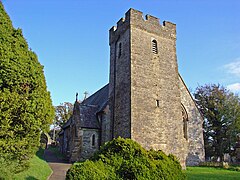 Clydau parish church | |
 Clydau Location within Pembrokeshire | |
| Population | 715 (2011)[1] |
| Principal area | |
| Country | Wales |
| Sovereign state | United Kingdom |
| Post town | Llanfyrnach |
| Postcode district | SA35 0 |
| Dialling code | 01239 |
| Police | Dyfed-Powys |
| Fire | Mid and West Wales |
| Ambulance | Welsh |
| UK Parliament | |
| Senedd Cymru – Welsh Parliament | |
Name edit
The meaning of the Welsh placename is uncertain, although the church is now dedicated to St. Clydaï, an alleged daughter of Brychan.[3]
History edit
During the early Middle Ages, the settlement was the site of Llangeneu ('St Ceneus'),[4] which was accounted one of the seven principal sees of Dyfed despite having no endowment of land.[5]
Cledau (as Cledye) appears on a 1578 parish map of Pembrokeshire.[6]
Erasmus Saunders (1670–1724), was born in Clydey; he was a Welsh priest and writer.[7] Josiah Thomas Jones (1799-1873), republican and Welsh nationalist, was born at CwmHir Farm, Clydau. He went on to publish many books and established several newspapers in English and Welsh, including the Aberdare Times.[8]
Settlement edit
The settlement consists of a small group of properties around the parish church, 5 miles (8.0 km) southwest of Newcastle Emlyn and 8 miles (13 km) southeast of Cardigan.
Community edit
Although the settlement of Clydau is tiny, the community is large, encompassing several other settlements and/or parishes including Bwlchygroes, Star, Tegryn, West Cilrhedyn and a large number of scattered farms.[9] Clydau has its own elected community council and gives its name to an electoral ward of Pembrokeshire County Council. The electoral ward of Clydau covers the communities of Clydau and Boncath. In 2001 it had a population (2001) of 1,425, with 58% Welsh speakers, falling to 715 in 2011.[1]
Parish edit
The Afon Cneifa, a tributary of Afon Cych, divides the parish into two ancient divisions: Uwchlawrllan to the southeast and Islawrllan to the northwest. The population of the parish was 1,100 (1801), 1,457 (1851), 1,057 (1901), 829 (1951), 681 (2001), 715 (2011). The percentage of Welsh speakers was: 99 (1891), 97 (1931) and 91 (1971).
The 14th century Grade II-listed parish church is dedicated to Ste. Clydaï.[10] It was rebuilt in the late 19th century, but the tower and some other parts of the building are original.[11]
References edit
- ^ a b "Community population 2011". Retrieved 17 April 2015.
- ^ "GENUKI: Clydey". Retrieved 27 November 2017.
- ^ Charles, B. G., The Placenames of Pembrokeshire, National Library of Wales, Aberystwyth, 1992, ISBN 0-907158-58-7, p 678
- ^ James, Heather. "The Geography of the Cult of St Davids" in St David of Wales: Cult, Church and Nation, p. 59. Boydell Press, 2007. Accessed 26 Mar 2013.
- ^ Wade-Evans, Arthur. Welsh Medieval Law, p. 263.
- ^ "Penbrok comitat". British Library. Archived from the original on 11 April 2021. Retrieved 4 April 2020.
- ^ Thomas, Daniel Lleufer (1897). . Dictionary of National Biography. Vol. 50. pp. 323–324.
- ^ "Josiah Thomas Jones". Retrieved 25 January 2020.
- ^ "GENUKI: 1850 Parish map". Retrieved 27 November 2017.
- ^ "British Listed Buildings: Church of Saint Clydai, Clydau". Retrieved 18 September 2016.
- ^ Cadw. "Church of Saint Clydai (Grade II) (11976)". National Historic Assets of Wales. Retrieved 22 July 2019.
External links edit
- Further historical information and sources on GENUKI
- Clydau Church website
- Community Council