
KNOWPIA
WELCOME TO KNOWPIA

Cobblestone Mountain (California) 
Summary
Cobblestone Mountain is a peak in the Topatopa Mountains, in Ventura County, about 14 mi (23 km) north of Piru, California. At 6,738 feet (2,054 m), it is the highest peak of the Topatopa Mountains. Second highest is Hines Peak.[2] Snow frequently falls on the mountain during winter.
| Cobblestone Mountain | |
|---|---|
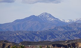 View of the mountain's eastern face | |
| Highest point | |
| Elevation | 6,738 ft (2,054 m) NAVD 88[1] |
| Prominence | 1,373 ft (418 m)[2] |
| Listing | Sierra Club Hundred Peaks Section[3] |
| Coordinates | 34°36′32″N 118°52′04″W / 34.608982411°N 118.867853019°W[1] |
| Geography | |
| Location | Ventura County California, U.S. |
| Parent range | Topatopa Mountains Transverse Ranges |
| Topo map | USGS Cobblestone Mountain |
| Climbing | |
| Easiest route | Hike[3] |
Overview edit
When viewing the Topatopa Mountains from the east, Cobblestone Mountain is the most visibly prominent mountain of the entire range. It can be seen from the Santa Clarita Valley, the San Fernando Valley from higher areas, on the westbound descent of the Santa Susana Pass on State Route 118, and in Gorman heading southbound on Interstate 5
The peak is in the Sespe Wilderness, which is part of the Los Padres National Forest.

See also edit
References edit
- ^ a b "Cobblestone". NGS Data Sheet. National Geodetic Survey, National Oceanic and Atmospheric Administration, United States Department of Commerce. Retrieved 2014-03-02.
- ^ a b "Cobblestone Mountain, California". Peakbagger.com. Retrieved 2014-03-02.
- ^ a b "Cobblestone Mountain". Hundred Peaks Section List. Angeles Chapter, Sierra Club. Retrieved 2014-02-23.