


Summary
Cochrane (/ˈkɒkrən/ KOK-rən) is a town in the Calgary Metropolitan Region of Alberta, Canada. The town is located 18 km (11 mi) west of the Calgary city limits along Highway 1A. Cochrane is one of the fastest-growing communities in Canada, and with a population of 32,199 in 2021, it is one of the largest towns in Alberta. It is part of Calgary's census metropolitan area and a member community of the Calgary Metropolitan Region Board (CMRB). The town is surrounded by Rocky View County.
Cochrane | |
|---|---|
Town | |
| Town of Cochrane | |
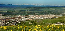 Overview of Cochrane | |
|
| |
| Motto: How the West is Now | |
 Boundaries of Cochrane | |
| Coordinates: 51°11′20″N 114°28′01″W / 51.189°N 114.467°W | |
| Country | Canada |
| Province | Alberta |
| Metropolitan area | Calgary |
| Planning region | South Saskatchewan |
| Municipal district | Rocky View County |
| Incorporated[1] | |
| • Village | June 17, 1903 |
| • Town | February 15, 1971 |
| Government | |
| • Mayor | Jeff Genung |
| • Governing body | Cochrane Town Council
|
| • CAO | Mike Derricott |
| • MP | Blake Richards (Cons – Banff—Airdrie) |
| • MLA | Peter Guthrie (UCP) – Airdrie-Cochrane) |
| Area (2021)[3] | |
| • Land | 31.58 km2 (12.19 sq mi) |
| Elevation | 1,159 m (3,802 ft) |
| Population | |
| • Total | 32,199 |
| • Density | 1,019.5/km2 (2,640/sq mi) |
| • Municipal census (2019) | 29,277[5] |
| • Estimate (2020) | 32,010[6] |
| Demonym | Cochranite[8] |
| Time zone | UTC−07:00 (MST) |
| • Summer (DST) | UTC−06:00 (MDT) |
| Forward sortation area | |
| Area code(s) | 403, 587, 825, 368 |
| Highways | |
| Railways | Canadian Pacific Kansas City |
| Website | www |


History edit
Cochrane was established in 1881 as the Cochrane Ranche, after Matthew Henry Cochrane, a local rancher. It became a village in 1903[9] and it had a newspaper and volunteer fire department by 1909.[10] Cochrane incorporated as a town in 1971.[9]
Geography edit
Cochrane is situated at the base of Big Hill in the Bow River Valley. It sits at an elevation of 1,186 m (3,891 ft). The town is intersected by Highway 1A and Highway 22. Cochrane has a reputation for its western culture—clearly seen when one wanders the streets (particularly Main Street). The town is a popular destination for ice cream and coffee in its quaint western-themed stores as well as for windsports, golfing, hiking and other adventure activities.
Cochrane is also a small industrial centre. Major industries include lumber, construction, retail, and agriculture (ranching). It is notable as being one of very few communities in Canada with no business tax.
The hill is also a popular training ground for cyclists from the area, who take advantage of its 7% grade and 3.5 km (2.2 mi) distance.
Neighbourhoods edit
The following neighbourhoods are located within Cochrane.[11]
- Bow Meadows
- Bow Ridge
- Cochrane Heights
- Downtown
- East End
- Fireside
- Glenbow
- GlenEagles
- Greystone
- Heartland
- Heritage Hills
- Jumping Pound Ridge
- Precedence
- Rivercrest
- Riversong
- Riviera
- Riverview
- Rolling Range Estates
- Rolling Trails
- Southbow Landing
- South Ridge
- Sunset Ridge
- The Willows
- West Pointe
- West Terrace
- West Valley
Sports edit
The Cochrane Generals are a Junior B Hockey Club based out of Cochrane Alberta Canada. They are members of the South Division In the Heritage Junior Hockey League. They have been playing out of the Original Cochrane Arena from (1984-2001) - (2018–Present)
Demographics edit
| Year | Pop. | ±% |
|---|---|---|
| 1901 | 92 | — |
| 1906 | 158 | +71.7% |
| 1911 | 395 | +150.0% |
| 1916 | 284 | −28.1% |
| 1921 | 268 | −5.6% |
| 1926 | 282 | +5.2% |
| 1931 | 293 | +3.9% |
| 1936 | 339 | +15.7% |
| 1941 | 298 | −12.1% |
| 1946 | 405 | +35.9% |
| 1951 | 530 | +30.9% |
| 1956 | 707 | +33.4% |
| 1961 | 857 | +21.2% |
| 1966 | 819 | −4.4% |
| 1971 | 1,046 | +27.7% |
| 1976 | 1,450 | +38.6% |
| 1981 | 3,544 | +144.4% |
| 1986 | 4,190 | +18.2% |
| 1991 | 5,267 | +25.7% |
| 1996 | 7,424 | +41.0% |
| 2001 | 11,798 | +58.9% |
| 2006 | 13,760 | +16.6% |
| 2011 | 17,580 | +27.8% |
| 2016 | 25,853 | +47.1% |
| 2021 | 32,199 | +24.5% |
| Source: Statistics Canada [12][13][14][15][16][17][18][19][20][21][22] [23][24][25][26][27][28][29][30][31][32][33][34] | ||
In the 2021 Census of Population conducted by Statistics Canada, the Town of Cochrane had a population of 32,199 living in 12,096 of its 12,578 total private dwellings, a change of 24.5% from its 2016 population of 25,853. With a land area of 31.58 km2 (12.19 sq mi), it had a population density of 1,019.6/km2 (2,640.8/sq mi) in 2021.[3]
The population of the Town of Cochrane according to its 2019 municipal census is 29,277,[5] a change of 4.7% from its 2018 municipal census population of 27,960.[35] At its current population, Cochrane is one of the largest towns in the province and is eligible for city status. According to Alberta's Municipal Government Act, a town is eligible for city status when it reaches 10,000 residents.[36]
In the 2016 Census of Population conducted by Statistics Canada, the Town of Cochrane recorded a population of 25,853 living in 9,757 of its 10,225 total private dwellings, a 47.1% change from its 2011 population of 17,580. With a land area of 29.83 km2 (11.52 sq mi), it had a population density of 866.7/km2 (2,244.7/sq mi) in 2016.[34]
Ethnicity edit
| Panethnic group | 2021[37] | 2016[38] | 2011[39] | 2006[40] | 2001[41] | |||||||||
|---|---|---|---|---|---|---|---|---|---|---|---|---|---|---|
| Pop. | % | Pop. | % | Pop. | % | Pop. | % | Pop. | % | |||||
| European[a] | 27,320 | 86.81% | 23,015 | 89.76% | 16,160 | 93.46% | 13,050 | 96.03% | 11,170 | 96.21% | ||||
| Indigenous | 1,470 | 4.67% | 1,075 | 4.19% | 510 | 2.95% | 285 | 2.1% | 260 | 2.24% | ||||
| Southeast Asian[b] | 980 | 3.11% | 540 | 2.11% | 160 | 0.93% | 60 | 0.44% | 0 | 0% | ||||
| South Asian | 510 | 1.62% | 220 | 0.86% | 125 | 0.72% | 20 | 0.15% | 65 | 0.56% | ||||
| East Asian[c] | 350 | 1.11% | 305 | 1.19% | 145 | 0.84% | 65 | 0.48% | 65 | 0.56% | ||||
| African | 350 | 1.11% | 180 | 0.7% | 105 | 0.61% | 45 | 0.33% | 40 | 0.34% | ||||
| Latin American | 280 | 0.89% | 140 | 0.55% | 55 | 0.32% | 0 | 0% | 0 | 0% | ||||
| Middle Eastern[d] | 100 | 0.32% | 90 | 0.35% | 0 | 0% | 20 | 0.15% | 10 | 0.09% | ||||
| Other/multiracial[e] | 115 | 0.37% | 80 | 0.31% | 0 | 0% | 45 | 0.33% | 0 | 0% | ||||
| Total responses | 31,470 | 97.74% | 25,640 | 99.18% | 17,290 | 98.35% | 13,590 | 98.76% | 11,610 | 96.42% | ||||
| Total population | 32,199 | 100% | 25,853 | 100% | 17,580 | 100% | 13,760 | 100% | 12,041 | 100% | ||||
| Note: Totals greater than 100% due to multiple origin responses | ||||||||||||||
Arts and culture edit
Cochrane Ranche provided the corral setting for the 1954 National Film Board of Canada documentary Corral, by Colin Low, whose father had worked as a foreman at the ranch. This film played theatrically across Canada and was named Best Documentary at the Venice Film Festival.[42]
Cochrane houses attractions such as Cochrane Ranche Historic Site and Bert Sheppard Stockmen's Foundation Library And Archives, located in the Cochrane Ranchehouse.
Cochrane is home to many annual events each year:
- Pumpkin lantern festival:[43] October
- Chamber of Commerce Trade Fair: Early May
- Canada Day (July 1)[44]
- Cochrane and Area Events Society, with support from the Town of Cochrane presents the Canada Day Community Celebration:[45] Canada Day (July 1)[44]
- Labour Day Rodeo & Parade: Labour Day weekend. In 2019 the parade had over 80 floats participate.
- Terry Fox Run: September
- Christmas Light-up: Late November
Government edit
- Municipal politics
Cochrane has a town council consisting of an elected mayor and six councillors elected at-large. Councillors are elected by the eligible electors by voting for up to six candidates and the six receiving the largest number of votes being elected. The position of deputy mayor is rotated through the councillors over their term. Elections are held on the third Monday in October every fourth year.
As of October 19, 2021, the town council consists of mayor Jeff Genung and Councillors Susan Flowers, Patrick Wilson, Morgan Nagel, Marni Fedeyko, Tara McFadden, Alex Reed.[46]
| Year | Liberal | Conservative | New Democratic | Green | |||||
|---|---|---|---|---|---|---|---|---|---|
| 2021 | 10% | 1,759 | 60% | 10,038 | 15% | 2,503 | 1% | 224 | |
| 2019 | 8% | 1,312 | 74% | 12,512 | 10% | 1,718 | 3% | 574 | |
| Year | United Cons. | New Democratic | |||
|---|---|---|---|---|---|
| 2019 | 63% | 9,802 | 29% | 4,482 | |
- Provincial politics
Cochrane is located within the provincial electoral division of Airdrie-Cochrane. It has been represented in the Alberta Legislature by UCP MLA Peter Guthrie since the 2019 provincial election.
- Federal politics
Cochrane is located in the federal electoral district of Banff-Airdrie and is represented by Blake Richards in the House of Commons. He also represented Cochrane from 2008-2015 as the MP for the federal electoral district of Wild Rose. He replaced long standing MP Myron Thompson, who was originally elected as a member of the Reform Party in 1993.
Education edit
Cochrane is home to schools from the public Rocky View School Division No. 41, the separate Calgary Catholic School District, and the Greater Southern Alberta Catholic Francophone Region #4 (CSCFSA).
As of 2022, there were twelve public and separate schools in operation within the town boundaries.[49]
- Rocky View School Division No. 41[50]
- Cochrane High School: Grades 9–12
- Bow Valley High School: Grades 9–12
- Rancheview School: Kindergarten, Grades 1-8
- Elizabeth Barret Elementary School: Kindergarten, Grades 1–4
- Glenbow Elementary School: Kindergarten, Grades 1–4
- Mitford School: Grades 5-8
- Manachaban Middle School|Manachaban Middle School Grades 5-8
- Cochrane Christian Academy: Kindergarten, Grades 1-8
- Fireside School: Kindergarten, Grades 1-8
- Calgary Catholic School District
- Holy Spirit: Kindergarten, Grades 1–6
- St. Timothy: Grades 7–12
- Nôtre Dame Des Vallées: Kindergarten, Grades 1–12(French-Catholic school GSACFR#4 or CSCFSA)
In November 2006 the Rocky View School Division accepted a proposal by the Cochrane Christ-Centred Education Society to set up a Protestant Christian education program in Cochrane. The Cochrane Christian Academy opened its doors at Mitford Middle School in September 2007, offering kindergarten to grade 4. Approval for expansion to include grade 5 for the 2008–09 school year was given by the board of trustees in April 2008.
There are two trustees (one from each board) elected to represent Cochrane Schools at their respective boards.
The Greater Southern Alberta Catholic Francophone Region #4 has one trustee for the Region from Cochrane.
Cochrane is also home to the Canadian Southern Baptist Seminary, the flagship seminary of the Canadian National Baptist Convention, the Canadian branch of the largest US Protestant denomination.
Notable people edit
- Rohan Campbell, actor
- Rob Cote, professional football player
- Justin Dowling, professional ice hockey player
- George Fox, musician
- Ethan Gage, professional soccer player
- Mason Raymond, professional ice hockey player
- Dillon Dubé, professional ice hockey player
- Paul Brandt, musician
- John Hufnagel President And GM of Calgary Stampeders
Transit edit
On October 7, 2019 the town launched COLT (Cochrane On-Demand Local Transit).[51] An app based local transportation service, described as an "Uber bus system".[51] The transit system, which was chosen due to its significantly lower operating cost compared to traditional route based transit, allows for users to request a ride on demand from one of over 150 stops in the town.[51][52] COLT has a partnership with On-It regional transit, providing an easy, inexpensive connection between Cochrane and Calgary.[53]
See also edit
Notes edit
- ^ Statistic includes all persons that did not make up part of a visible minority or an indigenous identity.
- ^ Statistic includes total responses of "Filipino" and "Southeast Asian" under visible minority section on census.
- ^ Statistic includes total responses of "Chinese", "Korean", and "Japanese" under visible minority section on census.
- ^ Statistic includes total responses of "West Asian" and "Arab" under visible minority section on census.
- ^ Statistic includes total responses of "Visible minority, n.i.e." and "Multiple visible minorities" under visible minority section on census.
References edit
- ^ "Location and History Profile: Town of Cochrane" (PDF). Alberta Municipal Affairs. June 17, 2016. p. 162. Retrieved June 19, 2016.
- ^ "Municipal Officials Search". Alberta Municipal Affairs. May 9, 2019. Retrieved October 1, 2021.
- ^ a b c "Population and dwelling counts: Canada, provinces and territories, and census subdivisions (municipalities)". Statistics Canada. February 9, 2022. Retrieved February 9, 2022.
- ^ "Alberta Private Sewage Systems 2009 Standard of Practice Handbook: Appendix A.3 Alberta Design Data (A.3.A. Alberta Climate Design Data by Town)" (PDF) (PDF). Safety Codes Council. January 2012. pp. 212–215 (PDF pages 226–229). Archived from the original (PDF) on October 16, 2013. Retrieved October 8, 2013.
- ^ a b "Cochrane's population continues to grow". Town of Cochrane. May 28, 2019. Retrieved June 8, 2019.
- ^ "Census Subdivision (Municipal) Population Estimates, July 1, 2016 to 2020, Alberta". Alberta Municipal Affairs. March 23, 2021. Retrieved October 8, 2021.
- ^ "Population and dwelling counts: Canada and population centres". Statistics Canada. February 9, 2022. Retrieved February 13, 2022.
- ^ "Way more than a ton". Cochrane Times. Canoe Sun Media. 2012-09-30. Archived from the original on 2016-03-03. Retrieved 2012-10-06.
- ^ a b "History of Cochrane". Town of Cochrane. Archived from the original on April 21, 2012. Retrieved December 9, 2012.
- ^ Read, Tracy (1983). Acres and Empires : a history of the Municipal District of Rocky View no. 44. p. 65. Archived from the original on 2017-03-03. Retrieved 2013-05-26.
- ^ "Neighbourhoods | Cochrane, AB - Official Website". www.cochrane.ca. Retrieved 2021-04-13.
- ^ "Table IX: Population of cities, towns and incorporated villages in 1906 and 1901 as classed in 1906". Census of the Northwest Provinces, 1906. Vol. Sessional Paper No. 17a. Ottawa: Government of Canada. 1907. p. 100.
- ^ "Table I: Area and Population of Canada by Provinces, Districts and Subdistricts in 1911 and Population in 1901". Census of Canada, 1911. Vol. I. Ottawa: Government of Canada. 1912. pp. 2–39.
- ^ "Table I: Population of Manitoba, Saskatchewan, and Alberta by Districts, Townships, Cities, Towns, and Incorporated Villages in 1916, 1911, 1906, and 1901". Census of Prairie Provinces, 1916. Vol. Population and Agriculture. Ottawa: Government of Canada. 1918. pp. 77–140.
- ^ "Table 8: Population by districts and sub-districts according to the Redistribution Act of 1914 and the amending act of 1915, compared for the census years 1921, 1911 and 1901". Census of Canada, 1921. Ottawa: Government of Canada. 1922. pp. 169–215.
- ^ "Table 7: Population of cities, towns and villages for the province of Alberta in census years 1901-26, as classed in 1926". Census of Prairie Provinces, 1926. Vol. Census of Alberta, 1926. Ottawa: Government of Canada. 1927. pp. 565–567.
- ^ "Table 12: Population of Canada by provinces, counties or census divisions and subdivisions, 1871-1931". Census of Canada, 1931. Ottawa: Government of Canada. 1932. pp. 98–102.
- ^ "Table 4: Population in incorporated cities, towns and villages, 1901-1936". Census of the Prairie Provinces, 1936. Vol. I: Population and Agriculture. Ottawa: Dominion Bureau of Statistics. 1938. pp. 833–836.
- ^ "Table 10: Population by census subdivisions, 1871–1941". Eighth Census of Canada, 1941. Vol. II: Population by Local Subdivisions. Ottawa: Dominion Bureau of Statistics. 1944. pp. 134–141.
- ^ "Table 6: Population by census subdivisions, 1926-1946". Census of the Prairie Provinces, 1946. Vol. I: Population. Ottawa: Dominion Bureau of Statistics. 1949. pp. 401–414.
- ^ "Table 6: Population by census subdivisions, 1871–1951". Ninth Census of Canada, 1951. Vol. I: Population, General Characteristics. Ottawa: Dominion Bureau of Statistics. 1953. p. 6.73–6.83.
- ^ "Table 6: Population by sex, for census subdivisions, 1956 and 1951". Census of Canada, 1956. Vol. Population, Counties and Subdivisions. Ottawa: Dominion Bureau of Statistics. 1957. p. 6.50–6.53.
- ^ "Population and dwelling counts, for Canada, provinces and territories, and census subdivisions (municipalities), 2011 and 2006 censuses (Alberta)". Statistics Canada. 2012-02-08. Retrieved 2012-02-08.
- ^ "Table 6: Population by census subdivisions, 1901–1961". 1961 Census of Canada. Series 1.1: Historical, 1901–1961. Vol. I: Population. Ottawa: Dominion Bureau of Statistics. 1963. p. 6.77–6.83.
- ^ "Population by specified age groups and sex, for census subdivisions, 1966". Census of Canada, 1966. Vol. Population, Specified Age Groups and Sex for Counties and Census Subdivisions, 1966. Ottawa: Dominion Bureau of Statistics. 1968. p. 6.50–6.53.
- ^ "Table 2: Population of Census Subdivisions, 1921–1971". 1971 Census of Canada. Vol. I: Population, Census Subdivisions (Historical). Ottawa: Statistics Canada. 1973. p. 2.102–2.111.
- ^ "Table 3: Population for census divisions and subdivisions, 1971 and 1976". 1976 Census of Canada. Census Divisions and Subdivisions, Western Provinces and the Territories. Vol. I: Population, Geographic Distributions. Ottawa: Statistics Canada. 1977. p. 3.40–3.43.
- ^ "Table 4: Population and Total Occupied Dwellings, for Census Divisions and Subdivisions, 1976 and 1981". 1981 Census of Canada. Vol. II: Provincial series, Population, Geographic distributions (Alberta). Ottawa: Statistics Canada. 1982. p. 4.1–4.10. ISBN 0-660-51095-2.
- ^ "Table 2: Census Divisions and Subdivisions – Population and Occupied Private Dwellings, 1981 and 1986". Census Canada 1986. Vol. Population and Dwelling Counts – Provinces and Territories (Alberta). Ottawa: Statistics Canada. 1987. p. 2.1–2.10. ISBN 0-660-53463-0.
- ^ "Table 2: Population and Dwelling Counts, for Census Divisions and Census Subdivisions, 1986 and 1991 – 100% Data". 91 Census. Vol. Population and Dwelling Counts – Census Divisions and Census Subdivisions. Ottawa: Statistics Canada. 1992. pp. 100–108. ISBN 0-660-57115-3.
- ^ "Table 10: Population and Dwelling Counts, for Census Divisions, Census Subdivisions (Municipalities) and Designated Places, 1991 and 1996 Censuses – 100% Data". 96 Census. Vol. A National Overview – Population and Dwelling Counts. Ottawa: Statistics Canada. 1997. pp. 136–146. ISBN 0-660-59283-5.
- ^ "Population and Dwelling Counts, for Canada, Provinces and Territories, and Census Divisions, 2001 and 1996 Censuses - 100% Data (Alberta)". Statistics Canada. Retrieved 2012-04-02.
- ^ "Population and dwelling counts, for Canada, provinces and territories, and census subdivisions (municipalities), 2006 and 2001 censuses - 100% data (Alberta)". Statistics Canada. 2010-01-06. Retrieved 2012-04-02.
- ^ a b "Population and dwelling counts, for Canada, provinces and territories, and census subdivisions (municipalities), 2016 and 2011 censuses – 100% data (Alberta)". Statistics Canada. February 8, 2017. Retrieved February 8, 2017.
- ^ 2018 Municipal Affairs Population List (PDF). Alberta Municipal Affairs. December 2018. ISBN 978-1-4601-4254-7. Retrieved July 18, 2019.
- ^ "Municipal Government Act". Alberta Queen's Printer. Retrieved September 5, 2012.
- ^ Government of Canada, Statistics Canada (2022-10-26). "Census Profile, 2021 Census of Population". www12.statcan.gc.ca. Retrieved 2023-04-06.
- ^ Government of Canada, Statistics Canada (2021-10-27). "Census Profile, 2016 Census". www12.statcan.gc.ca. Retrieved 2023-04-06.
- ^ Government of Canada, Statistics Canada (2015-11-27). "NHS Profile". www12.statcan.gc.ca. Retrieved 2023-04-06.
- ^ Government of Canada, Statistics Canada (2019-08-20). "2006 Community Profiles". www12.statcan.gc.ca. Retrieved 2023-04-06.
- ^ Government of Canada, Statistics Canada (2019-07-02). "2001 Community Profiles". www12.statcan.gc.ca. Retrieved 2023-04-06.
- ^ "Corral". NFB.ca. National Film Board of Canada. Retrieved 2009-09-01.
- ^ "Cochranes Historic Ranche will be lit up with pumpkins". CochraneToday.ca. 18 October 2019. Retrieved 2022-09-28.
- ^ a b "www.cochrane.ca - Annual Events". Archived from the original on 2011-07-06. Retrieved 2010-09-09.
- ^ "Canada Day". www.cochraneevents.ca. Retrieved 2022-06-25.
- ^ "Members of Council | Cochrane, AB - Official Website". www.cochrane.ca. Retrieved 2018-05-03.
- ^ "Official Voting Results Raw Data (poll by poll results in Cochrane)". Elections Canada. 14 April 2022. Retrieved March 3, 2023.
- ^ "Official Voting Results by polling station (poll by poll results in Cochrane)". Elections Alberta. Retrieved March 3, 2023.
- ^ "Schools | Cochrane, AB - Official Website". www.cochrane.ca. Retrieved 2022-09-28.
- ^ "Schools". www.rockyview.ab.ca. Retrieved 2022-10-03.
- ^ a b c Green, Kevin (October 6, 2019). "COLT transit on demand launches in Cochrane". Calgary. Retrieved September 28, 2022.
- ^ Firby, Doug (May 6, 2021). "Alberta town's COLT vehicles show the potential of 'demand-responsive transit'". The Globe and Mail.
- ^ Wilhelm, Steven (August 17, 2022). "Transit from Cochrane to Calgary enhanced by new service". The Cochrane Times.
External links edit
- Cochrane Official Website
