


Summary
Cold Aston (also known as Aston Blank) is a village and civil parish in Gloucestershire, England, approximately 18 miles (29 km) to the east of Gloucester.[3] It lies in the Cotswolds, an Area of Outstanding Natural Beauty. In the 2011 census, the population was 255.[2]
| Cold Aston | |
|---|---|
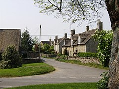 Cottages in Cold Aston | |
 Cold Aston Location within Gloucestershire | |
| Area | 3.71 sq mi (9.6 km2) [1] |
| Population | 255 [2] |
| • Density | 69/sq mi (27/km2) |
| • London | 77 miles (124 km) |
| Civil parish |
|
| District | |
| Shire county | |
| Region | |
| Country | England |
| Sovereign state | United Kingdom |
| Post town | CHELTENHAM |
| Postcode district | GL54 |
| Dialling code | 01451 |
| Police | Gloucestershire |
| Fire | Gloucestershire |
| Ambulance | South Western |
| UK Parliament | |
History edit
Toponymy edit
The village was recorded as Eastunæ between 716–43.[4] It was listed in the Domesday Book of 1086 as Estone, the name coming from the Old English ēast + tūn meaning "eastern farmstead or estate".[4][5] By the mid 13th century, the village was known as Cold Aston.[6] It was occasionally called Great Aston, to distinguish it from the nearby hamlet of Little Aston.[6] From the 16th century, the name Aston Blank took hold, the suffix "Blank" possibly deriving from the Old French word blanc, meaning "white" or "bare".[4][6] In 1972, the parish officially became known as Cold Aston again. Some think that the name "cold" is derived from the Saxon word which refers to a former settlement – in this case, probably referring to a disused Roman camp or rest place for use when travelling the Fosse Way. It is fairly certain, contrary to common modern thinking, that the word "Cold" has no link to a meteorological reference.[6]
Governance edit
Cold Aston is part of the Bourton-on-the-Water ward of the district of Cotswold, represented by Councillors Sheila Jeffery and Len Wilkins, and by Charles Alfred Richard Gillams, all members of the Conservative Party.[7][8] Cold Aston is part of the constituency of Cotswold, represented at parliament by Conservative MP Geoffrey Clifton-Brown.[9] It was part of the South West England constituency of the European Parliament prior to Britain leaving the European Union in January 2020.
Geography edit
Cold Aston is in the county of Gloucestershire and lies within the Cotswolds, a range of hills designated an Area of Outstanding Natural Beauty. It is approximately 18 miles (29 km) to the east of Gloucester. It is approximately 11 miles (18 km) east of its post town Cheltenham and about 2+1⁄2 miles (4.0 km) west of Bourton-on-the-Water. Nearby villages include Turkdean, Notgrove, Clapton, Naunton and Lower Slaughter.[3] The ancient parish of Cold Ashton contained 2,360 acres (3.69 sq mi; 9.6 km2) and was roughly square in shape, in 1987 the parish was enlarged.[1]
Landmarks edit

The Church of St Andrew is the Church of England parish church. It is a largely Norman building,[10] though its walls incorporate Saxon stonework and the original church on this site may have been built in around AD 904.[11] A leading modern authority refers approvingly to the "very good" west tower of three stages and other Perpendicular elements of the church, commenting, "All is evidently the work of the best Cotswold masons, and is the fifteenth-century aggrandizement of a Norman church".[12] Much of the present church was restored in 1875.[11]
The village pub, The Plough, is a 17th-century Grade II listed building.[13][14][15] It is the only pub between the three villages of Cold Aston, Turkdean and Notgrove in May 2013 re-opened after an extensive refurbishment. It now also offers accommodation. The pub's landlord claims that it is residence to a ghost named Old Harry.[15]
Education edit
The village has one primary school, Cold Aston Church of England Primary School, a voluntary controlled school for children from the age of 4–11.[16] In 2019, the school had 87 pupils.[17]
References edit
- ^ a b Carol Davidson Cragoe, A R J Jurica and Elizabeth Williamson, 'Parishes: Cold Aston', in A History of the County of Gloucester: Volume 9, Bradley Hundred. The Northleach Area of the Cotswolds, ed. N M Herbert (London, 2001), pp. 9-20. British History Online.
- ^ a b "Local Insight profile for 'Cold Aston CP' area" (PDF). Gloucestershire County Council. 15 January 2015.
- ^ a b Google. "Cold Aston" (Map). Google Maps. Google.
- ^ a b c Mills, A. D. (1998). Dictionary of English Place-Names. Oxford University Press. p. 17. ISBN 0-19-280074-4.
- ^ "Cold Aston". Domesday Book. The National Archives. 1086. Retrieved 10 July 2008.
- ^ a b c d "The History of Cold Aston". Official Cold Aston site. 2007. Retrieved 29 October 2019.
- ^ "Cold Aston Parish Council". Gloucestershire County Council. 4 September 2007. Retrieved 26 May 2008.
- ^ "Cotswold - Find your councillor". Cotswold District Council. Archived from the original on 15 June 2008. Retrieved 26 May 2008.
- ^ "Cotswold - Constituency - Conservative Party". Conservative Party. Archived from the original on 17 October 2006. Retrieved 28 April 2008.
- ^ "Cold Aston - St. Andrew". Gloucestershire County Council. 16 March 2006. Retrieved 26 May 2008.
- ^ a b "Cold Aston Village Church". Official Cold Aston site. 2007. Retrieved 29 October 2019.
- ^ Verey, David (1976). Cotswold Churches. B. T. Batsford Ltd. p. 193. ISBN 1845880285.
- ^ Historic England. "The Plough Inn (Grade II) (1341078)". National Heritage List for England. Retrieved 8 October 2020.
- ^ "The Plough". The Plough Official site. Archived from the original on 16 May 2013. Retrieved 23 May 2013.
- ^ a b "Cold Aston Village Pub". Official Cold Aston site. 2007. Retrieved 23 May 2013.
- ^ "League tables - Cold Aston Church of England Primary School". BBC. 6 December 2007. Retrieved 26 May 2008.
- ^ "Cold Aston Church of England Primary School". Ofsted. 2019. Retrieved 29 October 2019.
External links edit
- Official village site
- Aston [Blank] in the Domesday Book