


Summary
Columbia Gorge Regional Airport (IATA: DLS, ICAO: KDLS, FAA LID: DLS), also referred to as The Dalles Municipal Airport, is a public use airport in Klickitat County in the U.S. state of Washington. It is located near Dallesport, Washington and two nautical miles (4 km) northeast of the city of The Dalles in the state of Oregon.[1][2]This airport is included in the National Plan of Integrated Airport Systems for 2011–2015, which categorized it as a general aviation facility.[3]
Columbia Gorge Regional Airport The Dalles Municipal Airport | |||||||||||||||
|---|---|---|---|---|---|---|---|---|---|---|---|---|---|---|---|
 | |||||||||||||||
| Summary | |||||||||||||||
| Airport type | Public | ||||||||||||||
| Owner | City of The Dalles, Oregon | ||||||||||||||
| Operator | City of The Dalles, Oregon & Klickitat County, Washington | ||||||||||||||
| Serves | The Dalles, Oregon | ||||||||||||||
| Location | Dallesport, Washington | ||||||||||||||
| Elevation AMSL | 247 ft / 75 m | ||||||||||||||
| Coordinates | 45°37′07″N 121°10′02″W / 45.61861°N 121.16722°W | ||||||||||||||
| Website | flycgra.com | ||||||||||||||
| Map | |||||||||||||||
 DLS Location in Washington, near Oregon border | |||||||||||||||
| Runways | |||||||||||||||
| |||||||||||||||
| Statistics (2019) | |||||||||||||||
| |||||||||||||||
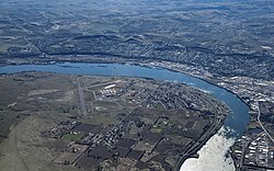
Despite being located in Washington, the airport is owned by the city of The Dalles (Oregon) since the 1940s and jointly operated with Klickitat County (Washington) since 2002.[4][5][1] It is adjacent to the Columbia River, near the east end of the Columbia River Gorge National Scenic Area.[6]

History edit
The airport, originally a grass strip, was named Case Field, in memory of Walter E. Case, a local airmail pilot who was killed in flight.[7]
During the Great Depression, the city was granted $12,000 by the Works Progress Administration (WPA), but that was later revoked in 1935 when the WPA learned the city only leased the airport.[8]
The airport was moved slightly and reconstructed in cement and pavement in 1943.[7] The airport was military surplus and became owned by the city of The Dalles, Oregon. In 2002, Klickitat County joined the city of The Dalles in a joint operating agreement.[4]
United Airlines provided commercial service to the airport from Portland and Boise from 1953 to 1955.[7]
Facilities and aircraft edit
The airport covers an area of 997 acres (403 ha) at an elevation of 247 feet (75 m) above mean sea level. It has two runways with asphalt surfaces: 13/31 is 5,097 by 100 feet (1,554 x 30 m) and 7/25 is 4,647 by 100 feet (1,416 x 30 m).[1]
For the 12-month period ending January 28, 2019, the airport had 16,282 aircraft operations, an average of 45 per day: 84% general aviation, 11% air taxi, and 5% military. At that time there were 67 aircraft based at this airport: 62 single-engine, 2 multi-engine, 2 helicopter, and 1 glider.[1]
References edit
- ^ a b c d e FAA Airport Form 5010 for DLS PDF. Federal Aviation Administration. Effective November 30, 2023.
- ^ "Map showing locations of airport, Dallesport, The Dalles, Washington/Oregon border, and Columbia River". MapQuest. Retrieved June 4, 2013.
- ^ "Appendix A: List of NPIAS Airports with 5-Year Forecast Activity and Development Cost" (PDF). National Plan of Integrated Airport Systems (2011-2015). Federal Aviation Administration. October 4, 2010. Archived from the original (PDF) on September 27, 2012. Retrieved April 1, 2018.
- ^ a b "IN THE MATTER OF APPOINTMENT TO THE COLUMBIA GORGE REGIONAL/THE DALLES MUNICIPAL AIRPORT BOARD". klickitatcounty.org. Retrieved 5 March 2024.
- ^ "Oregon Aviation Plan v6.0 - Columbia Gorge Regional - The Dalles Municipal Airport" (PDF). oregon.gov. Retrieved 5 March 2024.
- ^ Columbia River Gorge National Scenic Area
- ^ a b c "Washington Airport Management Association News" (PDF). wama.us. January 2021. Retrieved 5 March 2024.
- ^ "$12,000 Airport Grant For Dalles Rescinded". The Oregonian. Associated Press. December 7, 1935. p. 8.
External links edit
- Columbia Gorge Airport, official site
- The Dalles Municipal Airport at Washington State DOT
- Aerial image as of July 1996 from USGS The National Map
- FAA Terminal Procedures for DLS, effective April 18, 2024
- Resources for this airport:
- FAA airport information for DLS
- AirNav airport information for KDLS
- ASN accident history for DLS
- FlightAware airport information and live flight tracker
- NOAA/NWS weather observations: current, past three days
- SkyVector aeronautical chart, Terminal Procedures