
KNOWPIA
WELCOME TO KNOWPIA

Contremoulins 
Summary
Contremoulins (French pronunciation: [kɔ̃tʁəmulɛ̃]) is a commune in the Seine-Maritime department in the Normandy region in northern France.
Contremoulins | |
|---|---|
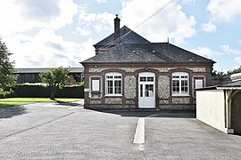 The town hall in Contremoulins | |
 Coat of arms | |
Location of Contremoulins .mw-parser-output .locmap .od{position:absolute}.mw-parser-output .locmap .id{position:absolute;line-height:0}.mw-parser-output .locmap .l0{font-size:0;position:absolute}.mw-parser-output .locmap .pv{line-height:110%;position:absolute;text-align:center}.mw-parser-output .locmap .pl{line-height:110%;position:absolute;top:-0.75em;text-align:right}.mw-parser-output .locmap .pr{line-height:110%;position:absolute;top:-0.75em;text-align:left}.mw-parser-output .locmap .pv>div{display:inline;padding:1px}.mw-parser-output .locmap .pl>div{display:inline;padding:1px;float:right}.mw-parser-output .locmap .pr>div{display:inline;padding:1px;float:left}html.skin-theme-clientpref-night .mw-parser-output .od,html.skin-theme-clientpref-night .mw-parser-output .od .pv>div,html.skin-theme-clientpref-night .mw-parser-output .od .pl>div,html.skin-theme-clientpref-night .mw-parser-output .od .pr>div{background:#000;color:#fff}html.skin-theme-clientpref-night .mw-parser-output .locmap{filter:grayscale(0.6)}@media(prefers-color-scheme:dark){html.skin-theme-clientpref-os .mw-parser-output .locmap{filter:grayscale(0.6)}html.skin-theme-clientpref-os .mw-parser-output .od,html.skin-theme-clientpref-os .mw-parser-output .od .pv>div,html.skin-theme-clientpref-os .mw-parser-output .od .pl>div,html.skin-theme-clientpref-os .mw-parser-output .od .pr>div{background:#000;color:#fff}}  Contremoulins  Contremoulins | |
| Coordinates: 49°43′36″N 0°25′41″E / 49.7267°N 0.4281°E | |
| Country | France |
| Region | Normandy |
| Department | Seine-Maritime |
| Arrondissement | Le Havre |
| Canton | Fécamp |
| Intercommunality | CA Fécamp Caux Littoral |
| Government | |
| • Mayor (2020–2026) | Gérard Colombel[1] |
| Area 1 | 4.38 km2 (1.69 sq mi) |
| Population (2021)[2] | 166 |
| • Density | 38/km2 (98/sq mi) |
| Time zone | UTC+01:00 (CET) |
| • Summer (DST) | UTC+02:00 (CEST) |
| INSEE/Postal code | 76187 /76400 |
| Elevation | 27–127 m (89–417 ft) (avg. 110 m or 360 ft) |
| 1 French Land Register data, which excludes lakes, ponds, glaciers > 1 km2 (0.386 sq mi or 247 acres) and river estuaries. | |
Geography edit
A small farming village, surrounded on 3 sides by woodland, situated in the Pays de Caux, some 26 miles (42 km) northeast of Le Havre, at the junction of the D68 and D926 roads.
Population edit
| Year | Pop. | ±% p.a. |
|---|---|---|
| 1968 | 151 | — |
| 1975 | 165 | +1.27% |
| 1982 | 176 | +0.93% |
| 1990 | 231 | +3.46% |
| 1999 | 208 | −1.16% |
| 2007 | 200 | −0.49% |
| 2012 | 189 | −1.13% |
| 2017 | 155 | −3.89% |
| Source: INSEE[3] | ||
Places of interest edit
- The eighteenth century ruined château of Franqueville.
- The château de Gruville.
- The church of St.Martin, dating from the seventeenth century.
See also edit
References edit
- ^ "Répertoire national des élus: les maires" (in French). data.gouv.fr, Plateforme ouverte des données publiques françaises. 13 September 2022.
- ^ "Populations légales 2021". The National Institute of Statistics and Economic Studies. 28 December 2023.
- ^ Population en historique depuis 1968, INSEE
Wikimedia Commons has media related to Contremoulins.