
KNOWPIA
WELCOME TO KNOWPIA

Corenc 
Summary
Corenc (French pronunciation: [kɔʁɑ̃]) is a commune in the département of Isère in southeastern France. It is part of the Grenoble urban unit (agglomeration).[3]
Corenc | |
|---|---|
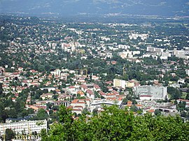 Corenc is in the background; in the foreground is La Tronche | |
 Coat of arms | |
Location of Corenc .mw-parser-output .locmap .od{position:absolute}.mw-parser-output .locmap .id{position:absolute;line-height:0}.mw-parser-output .locmap .l0{font-size:0;position:absolute}.mw-parser-output .locmap .pv{line-height:110%;position:absolute;text-align:center}.mw-parser-output .locmap .pl{line-height:110%;position:absolute;top:-0.75em;text-align:right}.mw-parser-output .locmap .pr{line-height:110%;position:absolute;top:-0.75em;text-align:left}.mw-parser-output .locmap .pv>div{display:inline;padding:1px}.mw-parser-output .locmap .pl>div{display:inline;padding:1px;float:right}.mw-parser-output .locmap .pr>div{display:inline;padding:1px;float:left}html.skin-theme-clientpref-night .mw-parser-output .od,html.skin-theme-clientpref-night .mw-parser-output .od .pv>div,html.skin-theme-clientpref-night .mw-parser-output .od .pl>div,html.skin-theme-clientpref-night .mw-parser-output .od .pr>div{background:#000;color:#fff}html.skin-theme-clientpref-night .mw-parser-output .locmap{filter:grayscale(0.6)}@media(prefers-color-scheme:dark){html.skin-theme-clientpref-os .mw-parser-output .locmap{filter:grayscale(0.6)}html.skin-theme-clientpref-os .mw-parser-output .od,html.skin-theme-clientpref-os .mw-parser-output .od .pv>div,html.skin-theme-clientpref-os .mw-parser-output .od .pl>div,html.skin-theme-clientpref-os .mw-parser-output .od .pr>div{background:#000;color:#fff}}  Corenc  Corenc | |
| Coordinates: 45°12′44″N 5°45′05″E / 45.2122°N 5.7514°E | |
| Country | France |
| Region | Auvergne-Rhône-Alpes |
| Department | Isère |
| Arrondissement | Grenoble |
| Canton | Meylan |
| Intercommunality | Grenoble-Alpes Métropole |
| Government | |
| • Mayor (2020–2026) | Jean-Damien Mermillod-Blondin[1] |
| Area 1 | 6.5 km2 (2.5 sq mi) |
| Population (2021)[2] | 4,139 |
| • Density | 640/km2 (1,600/sq mi) |
| Time zone | UTC+01:00 (CET) |
| • Summer (DST) | UTC+02:00 (CEST) |
| INSEE/Postal code | 38126 /38700 |
| Elevation | 221–1,328 m (725–4,357 ft) (avg. 467 m or 1,532 ft) |
| 1 French Land Register data, which excludes lakes, ponds, glaciers > 1 km2 (0.386 sq mi or 247 acres) and river estuaries. | |
Geography edit
Corenc is situated in the Alps near the center of the département of Isère.
Population edit
|
| ||||||||||||||||||||||||||||||||||||||||||||||||||||||||||||||||||||||||||||||||||||||||||||||||||||||||||||||||||
| Source: EHESS[4] and INSEE (1968-2017)[5] | |||||||||||||||||||||||||||||||||||||||||||||||||||||||||||||||||||||||||||||||||||||||||||||||||||||||||||||||||||
Economy edit
In 2007, Corenc's per capita income of €30,742 was the highest of any commune of France outside of the Paris region, and was nearly double the national average of €15,849.
See also edit
References edit
- ^ "Répertoire national des élus: les maires". data.gouv.fr, Plateforme ouverte des données publiques françaises (in French). 2 December 2020.
- ^ "Populations légales 2021". The National Institute of Statistics and Economic Studies. 28 December 2023.
- ^ Unité urbaine 2020 de Grenoble (38701), INSEE
- ^ Des villages de Cassini aux communes d'aujourd'hui: Commune data sheet Corenc, EHESS (in French).
- ^ Population en historique depuis 1968, INSEE
External links edit
Wikimedia Commons has media related to Corenc.
- Municipality of Corenc