
KNOWPIA
WELCOME TO KNOWPIA

Corent 
Summary
Corent (French pronunciation: [kɔʁɑ̃]) is a commune in the Puy-de-Dôme department in Auvergne-Rhône-Alpes in central France.
Corent | |
|---|---|
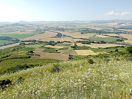 View from the Corent plateau | |
 Coat of arms | |
Location of Corent .mw-parser-output .locmap .od{position:absolute}.mw-parser-output .locmap .id{position:absolute;line-height:0}.mw-parser-output .locmap .l0{font-size:0;position:absolute}.mw-parser-output .locmap .pv{line-height:110%;position:absolute;text-align:center}.mw-parser-output .locmap .pl{line-height:110%;position:absolute;top:-0.75em;text-align:right}.mw-parser-output .locmap .pr{line-height:110%;position:absolute;top:-0.75em;text-align:left}.mw-parser-output .locmap .pv>div{display:inline;padding:1px}.mw-parser-output .locmap .pl>div{display:inline;padding:1px;float:right}.mw-parser-output .locmap .pr>div{display:inline;padding:1px;float:left}html.skin-theme-clientpref-night .mw-parser-output .od,html.skin-theme-clientpref-night .mw-parser-output .od .pv>div,html.skin-theme-clientpref-night .mw-parser-output .od .pl>div,html.skin-theme-clientpref-night .mw-parser-output .od .pr>div{background:#000;color:#fff}html.skin-theme-clientpref-night .mw-parser-output .locmap{filter:grayscale(0.6)}@media(prefers-color-scheme:dark){html.skin-theme-clientpref-os .mw-parser-output .locmap{filter:grayscale(0.6)}html.skin-theme-clientpref-os .mw-parser-output .od,html.skin-theme-clientpref-os .mw-parser-output .od .pv>div,html.skin-theme-clientpref-os .mw-parser-output .od .pl>div,html.skin-theme-clientpref-os .mw-parser-output .od .pr>div{background:#000;color:#fff}}  Corent  Corent | |
| Coordinates: 45°40′05″N 3°11′43″E / 45.6681°N 3.1953°E | |
| Country | France |
| Region | Auvergne-Rhône-Alpes |
| Department | Puy-de-Dôme |
| Arrondissement | Clermont-Ferrand |
| Canton | Les Martres-de-Veyre[1] |
| Government | |
| • Mayor (2020–2026) | Thierry Julien[2] |
| Area 1 | 2.68 km2 (1.03 sq mi) |
| Population (2021)[3] | 764 |
| • Density | 290/km2 (740/sq mi) |
| Time zone | UTC+01:00 (CET) |
| • Summer (DST) | UTC+02:00 (CEST) |
| INSEE/Postal code | 63120 /63730 |
| Elevation | 330–610 m (1,080–2,000 ft) (avg. 500 m or 1,600 ft) |
| 1 French Land Register data, which excludes lakes, ponds, glaciers > 1 km2 (0.386 sq mi or 247 acres) and river estuaries. | |
It sits approximately 2 miles north of Les Martres-de-Veyre on the side of the old volcanic Puy de Corent.
In 2001 excavation began on a Gallic (Celtic) and later Gallo-Roman Oppidum found in a field atop the puy. To this date, vast quantities of land have been excavated revealing the site as a main political, religious and economic center.[4] Corent was an important fortified Celtic oppidum during the pre-Roman La Tène period (Late Iron Age),[5] and there was already a dense fortified/walled settlement on the plateau during the Late Bronze Age Urnfield period.[6][7]
Gallic oppidum edit
-
![Reconstruction of the Corent oppidum, La Tène period.[8]](//upload.wikimedia.org/wikipedia/commons/thumb/8/81/Corent_oppidum_1.jpg/120px-Corent_oppidum_1.jpg) Reconstruction of the Corent oppidum, La Tène period.[8]
Reconstruction of the Corent oppidum, La Tène period.[8] -
 Corent sanctuary. See: Digital reconstruction
 -
 Sanctuary
 -
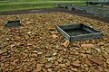 Sanctuary - libation pit
 -
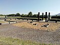
 Excavations
 -
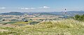 View from the plateau
![Reconstruction of the Corent oppidum, La Tène period.[8]](http://upload.wikimedia.org/wikipedia/commons/thumb/8/81/Corent_oppidum_1.jpg/120px-Corent_oppidum_1.jpg)


See also edit
References edit
- ^ "Décret 2014-210 du 21 février 2014 portant délimitation des cantons dans le département du Puy-de-Dôme" [2014-210 decree delimiting cantons of Puy-de-Dôme department]. Légifrance (in French). 21 February 2014.
- ^ "Répertoire national des élus: les maires" (in French). data.gouv.fr, Plateforme ouverte des données publiques françaises. 13 September 2022.
- ^ "Populations légales 2021". The National Institute of Statistics and Economic Studies. 28 December 2023.
- ^ Fouilles de Corent
- ^ Digital reconstruction of Corent oppidum, France.
- ^ Milcent, Pierre-Yves (2014). "Les occupations de l'âge du Bronze du plateau de Corent (Puy-de-Dôme): Résultats des campagnes de fouille 2010-2013". Bulletin APRAB. 12: 89–94.
- ^ Retour sur les fouilles de Corent 2021. Gergovia Museum. 2021.
- ^ Digital reconstruction of Corent oppidum, France.
External links edit
- 3D reconstruction of Corent oppidum, France (La Tene period)
Wikimedia Commons has media related to Corent.