
KNOWPIA
WELCOME TO KNOWPIA

Cornimont 
Summary
Cornimont (French pronunciation: [kɔʁnimɔ̃] ⓘ; German: Hornenberg) is a commune in the Vosges department in Grand Est in northeastern France.
Cornimont | |
|---|---|
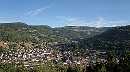 View of Cornimont from the mission cross. | |
 Coat of arms | |
Location of Cornimont .mw-parser-output .locmap .od{position:absolute}.mw-parser-output .locmap .id{position:absolute;line-height:0}.mw-parser-output .locmap .l0{font-size:0;position:absolute}.mw-parser-output .locmap .pv{line-height:110%;position:absolute;text-align:center}.mw-parser-output .locmap .pl{line-height:110%;position:absolute;top:-0.75em;text-align:right}.mw-parser-output .locmap .pr{line-height:110%;position:absolute;top:-0.75em;text-align:left}.mw-parser-output .locmap .pv>div{display:inline;padding:1px}.mw-parser-output .locmap .pl>div{display:inline;padding:1px;float:right}.mw-parser-output .locmap .pr>div{display:inline;padding:1px;float:left}html.skin-theme-clientpref-night .mw-parser-output .od,html.skin-theme-clientpref-night .mw-parser-output .od .pv>div,html.skin-theme-clientpref-night .mw-parser-output .od .pl>div,html.skin-theme-clientpref-night .mw-parser-output .od .pr>div{background:#000;color:#fff}html.skin-theme-clientpref-night .mw-parser-output .locmap{filter:grayscale(0.6)}@media(prefers-color-scheme:dark){html.skin-theme-clientpref-os .mw-parser-output .locmap{filter:grayscale(0.6)}html.skin-theme-clientpref-os .mw-parser-output .od,html.skin-theme-clientpref-os .mw-parser-output .od .pv>div,html.skin-theme-clientpref-os .mw-parser-output .od .pl>div,html.skin-theme-clientpref-os .mw-parser-output .od .pr>div{background:#000;color:#fff}}  Cornimont  Cornimont | |
| Coordinates: 47°57′50″N 6°50′23″E / 47.9639°N 6.8397°E | |
| Country | France |
| Region | Grand Est |
| Department | Vosges |
| Arrondissement | Saint-Dié-des-Vosges |
| Canton | La Bresse |
| Intercommunality | CC Hautes Vosges |
| Government | |
| • Mayor (2020–2026) | Marie-Josèphe Clement[1] |
| Area 1 | 40.23 km2 (15.53 sq mi) |
| Population (2021)[2] | 3,045 |
| • Density | 76/km2 (200/sq mi) |
| Time zone | UTC+01:00 (CET) |
| • Summer (DST) | UTC+02:00 (CEST) |
| INSEE/Postal code | 88116 /88310 |
| Elevation | 493–1,205 m (1,617–3,953 ft) |
| 1 French Land Register data, which excludes lakes, ponds, glaciers > 1 km2 (0.386 sq mi or 247 acres) and river estuaries. | |
History edit
A World War II tank battle was fought in Cornimont at Haut-du-Faing on 16 October 1944.
Population edit
| Year | Pop. | ±% p.a. |
|---|---|---|
| 1968 | 5,021 | — |
| 1975 | 5,211 | +0.53% |
| 1982 | 4,556 | −1.90% |
| 1990 | 4,042 | −1.49% |
| 1999 | 3,861 | −0.51% |
| 2007 | 3,732 | −0.42% |
| 2012 | 3,473 | −1.43% |
| 2017 | 3,208 | −1.57% |
| Source: INSEE[3] | ||
See also edit
References edit
- ^ "Répertoire national des élus: les maires" (in French). data.gouv.fr, Plateforme ouverte des données publiques françaises. 13 September 2022.
- ^ "Populations légales 2021". The National Institute of Statistics and Economic Studies. 28 December 2023.
- ^ Population en historique depuis 1968, INSEE
External links edit
Wikimedia Commons has media related to Cornimont.
- Official website (in French)