


Summary
The Cotabambas Province is a province located in the Apurímac Region of Peru. The province has a population of 44,028 inhabitants. The capital of this province is the city of Tambobamba.
Cotabambas | |
|---|---|
 Flag  Coat of arms | |
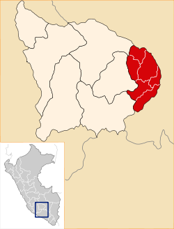 Location of Cotabambas in the Apurímac Region | |
| Country | Peru |
| Region | Apurímac |
| Capital | Tambobamba |
| Area | |
| • Total | 2,612.72 km2 (1,008.78 sq mi) |
| Population | |
| • Total | 44,028 |
| • Density | 17/km2 (44/sq mi) |
Boundaries edit
- North: Cusco Region
- East: Cusco Region
- South: Cusco Region
- West: Abancay Province, Grau Province, Antabamba Province
Geography edit
One of the highest peaks of the province is Wiska at approximately 4,800 m (15,700 ft). Other mountains are listed below:[1]
- Anka Wachana
- Aqchi Wachana
- Chunta
- Ch'uwañuma
- Huch'uy Miyu Kancha
- Jaqhira Sirka
- Kunturi
- Limaq
- Llulluch'a Urqu
- Llulluch'ayuq
- Millpuq
- Ñiq'ita
- Parqa Urqu
- Pukar
- Phiruru
- Quña Quta
- Qhawana Marka
- Qhillani
- Q'iswa Chakana
- Q'umir Qaqa
- Sipita
- Surimana
- Taya Sirk'a
- T'akra
- Wamanripayuq
- Waqra Waqra
- Waraquyuq
- Winku P'ukru
Political division edit
The province extends over an area of 2,612.72 square kilometers (1,008.78 sq mi) and is divided into six districts:
Ethnic groups edit
The people in the province are mainly indigenous citizens of Quechua descent. Quechua is the language which the majority of the population (90.18%) learnt to speak in childhood, 9.55 % of the residents started speaking using the Spanish language and 0.17% using Aymara (2007 Peru Census).[2]
See also edit
References edit
- ^ escale.minedu.gob.pe/ UGEL map Aymaraes Province, Grau Province (Apurímac Region)
- ^ inei.gob.pe Archived January 27, 2013, at the Wayback Machine INEI, Peru, Censos Nacionales 2007
External links edit
- www.cotabambas.com
13°56′31″S 72°10′52″W / 13.942°S 72.181°W