
KNOWPIA
WELCOME TO KNOWPIA

Coullemont 
Summary
Coullemont (French pronunciation: [kulmɔ̃]; Picard: Coulonmont) is a commune in the Pas-de-Calais department in the Hauts-de-France region of France.[3]
Coullemont | |
|---|---|
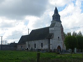 The church of Coullemont | |
 Coat of arms | |
Location of Coullemont .mw-parser-output .locmap .od{position:absolute}.mw-parser-output .locmap .id{position:absolute;line-height:0}.mw-parser-output .locmap .l0{font-size:0;position:absolute}.mw-parser-output .locmap .pv{line-height:110%;position:absolute;text-align:center}.mw-parser-output .locmap .pl{line-height:110%;position:absolute;top:-0.75em;text-align:right}.mw-parser-output .locmap .pr{line-height:110%;position:absolute;top:-0.75em;text-align:left}.mw-parser-output .locmap .pv>div{display:inline;padding:1px}.mw-parser-output .locmap .pl>div{display:inline;padding:1px;float:right}.mw-parser-output .locmap .pr>div{display:inline;padding:1px;float:left}html.skin-theme-clientpref-night .mw-parser-output .od,html.skin-theme-clientpref-night .mw-parser-output .od .pv>div,html.skin-theme-clientpref-night .mw-parser-output .od .pl>div,html.skin-theme-clientpref-night .mw-parser-output .od .pr>div{background:#000;color:#fff}html.skin-theme-clientpref-night .mw-parser-output .locmap{filter:grayscale(0.6)}@media(prefers-color-scheme:dark){html.skin-theme-clientpref-os .mw-parser-output .locmap{filter:grayscale(0.6)}html.skin-theme-clientpref-os .mw-parser-output .od,html.skin-theme-clientpref-os .mw-parser-output .od .pv>div,html.skin-theme-clientpref-os .mw-parser-output .od .pl>div,html.skin-theme-clientpref-os .mw-parser-output .od .pr>div{background:#000;color:#fff}}  Coullemont  Coullemont | |
| Coordinates: 50°12′58″N 2°28′30″E / 50.2161°N 2.475°E | |
| Country | France |
| Region | Hauts-de-France |
| Department | Pas-de-Calais |
| Arrondissement | Arras |
| Canton | Avesnes-le-Comte |
| Intercommunality | CC Campagnes de l'Artois |
| Government | |
| • Mayor (2020–2026) | Patrick Dekeyser[1] |
| Area 1 | 4.04 km2 (1.56 sq mi) |
| Population (2021)[2] | 120 |
| • Density | 30/km2 (77/sq mi) |
| Time zone | UTC+01:00 (CET) |
| • Summer (DST) | UTC+02:00 (CEST) |
| INSEE/Postal code | 62243 /62158 |
| Elevation | 110–170 m (360–560 ft) (avg. 146 m or 479 ft) |
| 1 French Land Register data, which excludes lakes, ponds, glaciers > 1 km2 (0.386 sq mi or 247 acres) and river estuaries. | |
Geography edit
A small farming village located 15 miles (24 km) southwest of Arras at the junction of the D23 and D80 roads, on the border with the département of the Somme.
Population edit
| Year | Pop. | ±% p.a. |
|---|---|---|
| 1968 | 103 | — |
| 1975 | 89 | −2.07% |
| 1982 | 86 | −0.49% |
| 1990 | 104 | +2.40% |
| 1999 | 105 | +0.11% |
| 2007 | 109 | +0.47% |
| 2012 | 105 | −0.74% |
| 2017 | 122 | +3.05% |
| Source: INSEE[4] | ||
Places of interest edit
- The church of St.Nicholas, dating from the thirteenth century.
- A Commonwealth War Graves Commission grave.
See also edit
References edit
- ^ "Répertoire national des élus: les maires". data.gouv.fr, Plateforme ouverte des données publiques françaises (in French). 9 August 2021.
- ^ "Populations légales 2021". The National Institute of Statistics and Economic Studies. 28 December 2023.
- ^ INSEE commune file
- ^ Population en historique depuis 1968, INSEE
External links edit
Wikimedia Commons has media related to Coullemont.
- The CWGC grave