


Summary
Crazy Quilt Mesa is a 6,760 ft (2,060 m) elevation white Navajo Sandstone summit located in Zion National Park, in Kane County of southwest Utah, United States.
| Crazy Quilt Mesa | |
|---|---|
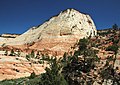
 Northwest aspect, from Zion – Mount Carmel Highway | |
| Highest point | |
| Elevation | 6,760 ft (2,060 m)[1] |
| Prominence | 728 ft (222 m)[2] |
| Parent peak | Clear Creek Mountain (8,123 ft)[1] |
| Isolation | 2.56 mi (4.12 km)[1] |
| Coordinates | 37°12′43″N 112°53′20″W / 37.2120°N 112.8889°W[1] |
| Geography | |
 Crazy Quilt Mesa Location in Utah  Crazy Quilt Mesa Crazy Quilt Mesa (the United States) | |
| Country | United States |
| State | Utah |
| County | Kane |
| Protected area | Zion National Park |
| Parent range | Colorado Plateau |
| Topo map | USGS Springdale East |
| Geology | |
| Age of rock | Jurassic |
| Type of rock | Navajo sandstone |
| Climbing | |
| Easiest route | class 2+ scrambling[1] |
Description edit
Crazy Quilt Mesa is situated southwest of the park's east entrance, towering 1,000 feet (300 meters) above the Zion – Mount Carmel Highway. Its nearest neighbor is Checkerboard Mesa, one-half mile immediately east, and separated by Checkerboard Mesa Canyon. This canyon holds pools of rainwater which provide a vital source of water for resident bighorn sheep.[3] Other nearby peaks include Nippletop to the west and Ant Hill to the northwest. Precipitation runoff from this mountain drains into tributaries of the Virgin River.
Climate edit
Spring and fall are the most favorable seasons to visit Crazy Quilt Mesa. According to the Köppen climate classification system, it is located in a Cold semi-arid climate zone, which is defined by the coldest month having an average mean temperature below 32 °F (0 °C), and at least 50% of the total annual precipitation being received during the spring and summer. This desert climate receives less than 10 inches (250 millimeters) of annual rainfall, and snowfall is generally light during the winter.[4]
See also edit
Gallery edit
-
-

-
 Checkerboard Mesa (left) and Crazy Quilt Mesa (right) from northeast
 -
 Northeast aspect


References edit
- ^ a b c d e ""Crazy Quilt Mesa" - 6,760' UT". listsofjohn.com. Retrieved 2020-09-09.
- ^ "Crazy Quilt West, Utah". Peakbagger.com.
- ^ Scott Turner, "Hike the Parks: Zion & Bryce Canyon National Parks", 2019, The Mountaineers Books.
- ^ "Zion National Park, Utah, USA - Monthly weather forecast and Climate data". Weather Atlas. Archived from the original on January 27, 2019. Retrieved 31 August 2020.
External links edit
- Zion National Park National Park Service
- Weather forecast: National Weather Service
- Crazy Quilt Mesa rock climbing: Mountainproject.com