


Summary
The Crimean Mountains (Crimean Tatar: Qırım dağları; Ukrainian: Кримські гори; Russian: Крымские горы; Turkish: Yayla Dağları) or Yayla Mountains are a range of mountains running parallel to the south-eastern coast of Crimea, between about 8–13 kilometers (5–8 miles) from the sea. Toward the west, the mountains drop steeply to the Black Sea, and to the east, they change slowly into a steppe landscape.
| Crimean Mountains | |
|---|---|
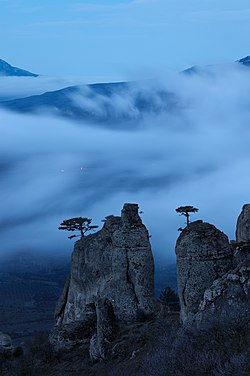 Twilight on Demirci yayla | |
| Highest point | |
| Peak | Roman-Kosh |
| Elevation | 1,545 m (5,069 ft) |
| Coordinates | 44°36′47″N 34°14′36″E / 44.61306°N 34.24333°E |
| Naming | |
| Native name |
|
| Geography | |

| |
| Location | Southern Crimea |
| Range coordinates | 44°45′N 34°30′E / 44.750°N 34.500°E |
| Geology | |
| Age of rock | Cretaceous |
The Crimean Mountains consist of three subranges. The highest is the Main Range, which is subdivided into several yaylas or mountain plateaus (yayla or yaylak is Turkic for "alpine meadow"). They are:
- Baydar yayla
- Ai-Petri yayla
- Yalta yayla
- Nikita yayla
- Hurzuf yayla
- Babugan yayla
- Chatyr-Dag yayla
- Dologorukovskaya (Subatkan) yayla
- Demirci yayla
- Qarabiy yayla
Highest peaks edit
The Crimea's highest peak is the Roman-Kosh (Ukrainian: Роман-Кош; Russian: Роман-Кош, Crimean Tatar: Roman Qoş) on the Babugan Yayla at 1,545 metres (5,069 ft). Other important peaks over 1,200 metres include:
- Demir-Kapu (Ukrainian: Демір-Капу, Russian: Демир-Капу, Crimean Tatar: Demir Qapı) 1,540 m in the Babugan Yayla;
- Zeytin-Kosh (Ukrainian: Зейтин-Кош; Russian: Зейтин-Кош, Crimean Tatar: Zeytün Qoş) 1,537 m in the Babugan Yayla;
- Kemal-Egerek (Ukrainian: Кемаль-Егерек, Russian: Кемаль-Эгерек, Crimean Tatar: Kemal Egerek) 1,529 m in the Babugan Yayla;
- Eklizi-Burun (Ukrainian: Еклізі-Бурун, Russian: Эклизи-Бурун, Crimean Tatar: Eklizi Burun) 1,527 m in the Chatyrdag Yayla;
- Lapata (Ukrainian: Лапата; Russian: Лапата, Crimean Tatar: Lapata) 1,406 m in the Yaltynska Yayla, Yalta Yaylası;
- Northern Demirji (Ukrainian: Північний Демірджі, Russian: Северный Демирджи, Crimean Tatar: Şimaliy Demirci) 1,356 m in the Demirci Yayla;
- Ai-Petri (Ukrainian: Ай-Петрі, Russian: Ай-Петри, Crimean Tatar: Ay Petri) 1,234 m in the Ay Petri Yaylası.
Passes and rivers edit
The passes over the Crimean Mountains are: (from east to west)
- Angarskyi Pass (752m) near Perevalne, on a road from Alushta to Simferopol
- Okhotnyche (1185m) near Ai-Petri mountain peak, on the road from Yalta to Bakhchysarai
- Baydar Gate (503m) near Foros, connecting Baydar Valley and the sea coast
- Laspi Pass (350m) near Cape Aya, on a road from Yalta to Sevastopol.
Rivers of the Crimean Mountains include the Alma River, Chernaya River, and Salhir River on the northern slope and Uchan-su River on the southern slope which forms the Uchan-su waterfall, and the highest waterfall in Crimea.
History edit
Archaeologists have found the earliest anatomically modern humans in Europe in the Crimean Mountains' Buran-Kaya caves. The fossils are 32,000 years old, with the artifacts linked to the Gravettian culture. The fossils have cut marks suggesting a post-mortem defleshing ritual.[1][2]
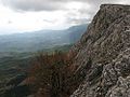
Gallery edit
-
 Qarabiy yayla
 -
 Qarabiy yayla
 -
 Qarabiy yayla
 -
 Mountain plateau of Chatyr-Dag mountain
 -
 The Crimean Mountains


See also edit
References edit
- ^ Prat, Sandrine; Péan, Stéphane C.; Crépin, Laurent; Drucker, Dorothée G.; Puaud, Simon J.; Valladas, Hélène; Lázničková-Galetová, Martina; van der Plicht, Johannes; et al. (17 June 2011). "The Oldest Anatomically Modern Humans from Far Southeast Europe: Direct Dating, Culture and Behavior". PLOS ONE. 6 (6). plosone: e20834. Bibcode:2011PLoSO...620834P. doi:10.1371/journal.pone.0020834. PMC 3117838. PMID 21698105.
- ^ Carpenter, Jennifer (20 June 2011). "Early human fossils unearthed in Ukraine". BBC. Retrieved 21 June 2011.
External links edit
- Crimean mountains – view on all parts of mountains of Crimea
- Mountains of Crimea – Great collection of Crimean mountains from private mountain guide Sergey Sorokin