


Summary
Crown King is an unincorporated community in Yavapai County, Arizona, United States, located at an elevation of 5,771 feet (1,759 m).[2] Crown King has a ZIP Code of 86343; in 2000, the population of the 86343 ZCTA was 133.[3] The site of a former gold mining town, Crown King is 28 miles west of Interstate 17 on Senator Highway, high in the Bradshaw Mountains. The community is named after the Crowned King mine, but the name was shortened to Crown King in 1888. Horsethief Basin Lake resides 6.5 miles southeast of Crown King on Crown King Rd/Forest 259 Rd.
Crown King, Arizona | |
|---|---|
Unincorporated community | |
 Crown King Saloon | |
 Crown King, Arizona Location in the state of Arizona  Crown King, Arizona Crown King, Arizona (the United States) | |
| Coordinates: 34°12′20″N 112°20′19″W / 34.20556°N 112.33861°W | |
| Country | United States |
| State | Arizona |
| County | Yavapai |
| Founded | 1875 |
| Named for | Crowned King Mine[1] |
| Elevation | 5,771 ft (1,759 m) |
| Population (2000) | |
| • Total | 133 |
| Time zone | UTC-7 (MST (no DST)) |
| Post Office opened | July 29, 1888 |
| Post Office closed | May 15, 1954 |
| GNIS feature ID | 28197 |
History edit
An estimated US$2,000,000 in gold was taken from the Crowned King Mine alone; the mines have been closed since the 1950s and for the past half-century tourism has been the only reliable source of income in the area, despite the fact that the unpaved, mountainous access roads are rocky, rough and slow to drive.
The first recorded gold claim in Crown King was "Buckeye" and was filed by Rod McKinnon on July 1, 1875. Over the next 40 years, more than 15 mines or claims were made in the area. At its height, the town had 500 buildings, including several company stores and boarding houses, two Chinese restaurants and a post office. The town was electrified by 1897 and had one telephone at that time.
While an active mining town, Crown King was served by the Bradshaw Mountain Railroad. Rail service to the area began in 1904 upon completion of "Murphy's Impossible Railroad" – a series of switchbacks and trestles that ascended the mountain terrain between Cleator and Crown King. The railroad began in Mayer, Arizona, connecting with Murphy's Prescott and Eastern Railroad and extended for 28 miles amid the rocky terrain.[4]
Crown King was the terminus (1904–1926) of the railroad, built by Frank M. Murphy to serve the mines of the southern Bradshaw Mountains. However, these mines were never very productive, and the BMRR was a financial failure. The line was abandoned in 1926. Much of the road to Crown King uses the old railroad bed.[5]
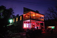
Of the buildings still standing and in use in Crown King, the Crown King Saloon has maintained its place as the center of activity in town. The Saloon was originally constructed and operated in the nearby mining town of Oro Belle (now also a ghost town). In 1910, it was disassembled and brought to Crown King piece by piece after the mine at Oro Belle had played out. The building was home to a brothel and bar in both towns and now serves the public as a hotel, cafe, and bar. The town has a cemetery nearby.[6]
The red one-room schoolhouse was built in 1917 and still serves a small number of K–8 students. High school students typically leave town to attend class 14 miles away in Mayer.
The post office was established on July 29, 1888, and was discontinued on May 15, 1954.[7] It has since reopened inside the Crown King General Store.
Climate edit
According to the Köppen climate classification system, Crown King has a Mediterranean climate, classified as Csb on climate maps. It is atypical of this type because its dry season only covers the first half of summer and is followed by heavy monsoonal thunderstorms in July and August.
An exposed location relative to moist southerly airflows from the Gulf of California gives Crown King among the highest precipitation in Arizona – in fact it holds the official state record for the most precipitation in one calendar month with 16.95 inches (430.5 mm) in August 1951,[8] and the station has thrice approached this record with 16.21 inches (411.7 mm) in December 1967 (including 87.3 inches or 2.22 metres of snow), 16.63 inches (422.4 mm) in February 1980 and 16.75 inches (425.4 mm) in January 1993.[9] The wettest days have been April 17, 1917 with 7.65 inches (194.3 mm) and December 31, 1948 with 7.10 inches (180.3 mm). The wettest calendar year has been 1978 with 56.42 inches (1,433.1 mm) and the driest 1960 with 14.31 inches (363.5 mm).[9] Snowfall can be heavy, with 87.3 inches (2.22 m) falling in January 1949, although in general snow cover is minimal due to relatively warm days in winter.
| Climate data for Crown King, Arizona (1914–1995) | |||||||||||||
|---|---|---|---|---|---|---|---|---|---|---|---|---|---|
| Month | Jan | Feb | Mar | Apr | May | Jun | Jul | Aug | Sep | Oct | Nov | Dec | Year |
| Record high °F (°C) | 70 (21) |
75 (24) |
79 (26) |
85 (29) |
94 (34) |
104 (40) |
102 (39) |
101 (38) |
94 (34) |
90 (32) |
80 (27) |
69 (21) |
104 (40) |
| Mean daily maximum °F (°C) | 49.0 (9.4) |
52.0 (11.1) |
56.9 (13.8) |
66.0 (18.9) |
74.0 (23.3) |
86.0 (30.0) |
87.7 (30.9) |
84.4 (29.1) |
80.1 (26.7) |
69.7 (20.9) |
58.2 (14.6) |
51.3 (10.7) |
68.0 (20.0) |
| Mean daily minimum °F (°C) | 25.8 (−3.4) |
27.3 (−2.6) |
30.4 (−0.9) |
35.8 (2.1) |
41.4 (5.2) |
51.6 (10.9) |
57.5 (14.2) |
55.8 (13.2) |
49.6 (9.8) |
39.9 (4.4) |
31.2 (−0.4) |
26.7 (−2.9) |
39.4 (4.1) |
| Record low °F (°C) | −5 (−21) |
0 (−18) |
11 (−12) |
16 (−9) |
22 (−6) |
31 (−1) |
41 (5) |
43 (6) |
32 (0) |
17 (−8) |
12 (−11) |
−5 (−21) |
−5 (−21) |
| Average precipitation inches (mm) | 3.34 (85) |
3.16 (80) |
2.91 (74) |
1.43 (36) |
0.60 (15) |
0.46 (12) |
3.37 (86) |
4.38 (111) |
2.11 (54) |
1.48 (38) |
1.89 (48) |
3.34 (85) |
28.47 (724) |
| Average snowfall inches (cm) | 9.9 (25) |
7.8 (20) |
6.7 (17) |
2.1 (5.3) |
0.1 (0.25) |
0.0 (0.0) |
0.0 (0.0) |
0.0 (0.0) |
0.0 (0.0) |
0.3 (0.76) |
2.1 (5.3) |
8.2 (21) |
37.2 (94.61) |
| Average precipitation days (≥ 0.01 inch) | 5 | 5 | 5 | 3 | 2 | 2 | 9 | 9 | 5 | 3 | 3 | 4 | 55 |
| Source: Western Regional Climate Center[9] | |||||||||||||
References edit
- ^ Varney, Philip (2005). "Yavapai Ghosts". In Stieve, Robert (ed.). Arizona Ghost Towns and Mining Camps: A Travel Guide to History (10th ed.). Phoenix, Arizona: Arizona Highways Books. pp. 20–21. ISBN 1932082468.
- ^ a b U.S. Geological Survey Geographic Names Information System: Crown King
- ^ "American FactFinder – Community Facts". Archived from the original on February 12, 2020. Retrieved July 13, 2010.
- ^ "Crown King Arizona Mining History". www.mininghistoryassociation.org. Retrieved April 19, 2019.
- ^ John W. Sayre, 1985, Ghost Railroads of Central Arizona, Boulder, Colo.: Pruett, ISBN 0871086832
- ^ Varney, Philip (1980). "One: Near Prescott • Ghosts of the Higher Ground". Arizona's Best Ghost Towns. Flagstaff: Northland Press. pp. 7–8. ISBN 0873582179. LCCN 79-91724.
- ^ Sherman, James E.; Barbara H. Sherman (1969). "Crown King". Ghost Towns of Arizona (First ed.). University of Oklahoma Press. pp. 48–49. ISBN 0806108436.
- ^ National Oceanic and Atmospheric Administration; Weather Extremes for the Western States
- ^ a b c Western Regional Climate Center; Crown King, AZ; Period of Record General Climate Summary: Precipitation
Further reading edit
- Bruce M. Wilson, Crown King and the Southern Bradshaws: A Complete History, Mesa, Crown King Press, 1990, 104 pages. ISBN 0962757306
- Du Shane, Neal (July 1, 2007). "Crown King, Arizona". American Pioneer & Cemetery Research Project.
External links edit
- Crown King – ghosttowns.com
 Media related to Crown King, Arizona at Wikimedia Commons
- Crown King Fire District
- Crown King Elementary School District
- Crown King Chamber of Commerce
- Crown King Historical Society