


Summary
Crystal Springs Dam is a gravity dam constructed across the San Mateo Creek which is in San Mateo County, California. It impounds water to form the Lower Crystal Springs Reservoir which sits atop the San Andreas Fault in a rift valley created by the fault. The dam itself is located about 300 yards (273 meters) east of the fault.[1][2] It was among the first concrete gravity dams built in the western United States.[3] Skyline Boulevard runs over the dam, which also forms the trailhead of the popular Sawyer Camp Trail.
| Crystal Springs Dam | |
|---|---|
 | |
| Official name | Lower Crystal Springs Dam |
| Location | San Mateo County, California |
| Coordinates | 37°31′43″N 122°21′44″W / 37.5285°N 122.3622°W |
| Opening date | 1888 |
| Operator(s) | San Francisco Public Utilities Commission |
| Dam and spillways | |
| Impounds | San Mateo Creek |
| Height | 140 ft (43 m) |
| Length | 600 ft (180 m) |
| Width (base) | 40 ft (12 m) |
| Reservoir | |
| Creates | Lower Crystal Springs Reservoir |
| Total capacity | 57,910 acre⋅ft (71,430,000 m3) |
| Catchment area | 29.4 sq mi (76 km2) |
| Surface area | 1,323 acres (5.35 km2) |
History edit
The structure was completed in 1888. At the time of its completion, it was the largest concrete structure in the world.[4]
The designer was Hermann Schussler, Chief Engineer of the Spring Valley Water Company.
The dam was constructed by separately pouring large blocks of the structure in place, and allowing them to set before pouring the adjoining blocks. An important design feature is that neither the horizontal nor the vertical joints line up. This helps the structure act as a single monolithic construction despite being made of thousands of individual blocks.
Schussler ensured that each block of the dam was poured with concrete made to the exact proportions of his mix specifications.
In 1976, the dam was designated as a California Historic Civil Engineering Landmark by the American Society of Civil Engineers.[5][6]

The dam has survived both the 1906 San Francisco earthquake and the 1989 Loma Prieta earthquake – despite its location about 300 yards (270 m) east of the San Andreas Fault. It was subject to severe shaking in both earthquakes.[3]
Repairs edit
The San Francisco Public Utilities Commission began the process of renovating the dam in 2003. A major step in the renovation process, doubling the width of the main spillway and raising the dam to increase the water storage capacity, was completed in 2012. The renovations, which are intended to improve the reliability of the system in the event of an earthquake, were completed in 2016. Skyline Boulevard on top of the dam was closed for construction in October 2010. Construction completed in late 2018 and the roadway was reopened in January 2019.[7][8]
The bridge closed again to vehicular traffic on February 10, 2020, for the Lower Crystal Springs Dam Pond and Parapet Project with an expected completion and re-opening date of April 3, 2020.[9]
-
 Crystal Springs Dam from downstream
 -
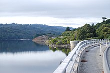
 Lower Crystal Springs Reservoir
 -
 Aerial view of the Crystal Springs Reservoir from the southeast
 -
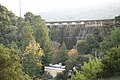
 View from under the California State Route 35 roadway that was added atop the dam


See also edit
References edit
- Department of Water Resources (2009). "Station Meta Data: Lower Crystal Springs Dam (CRY)". California Data Exchange Center. State of California. Retrieved 2009-04-01.
- "Crystal Spring Dam". Geographic Names Information System. United States Geological Survey, United States Department of the Interior. 19 Jan 1981. Retrieved 2009-06-11.
- U.S. Geological Survey (24 November 2003). "Crystal Springs Reservoir". U.S. Department of the Interior. Archived from the original on December 6, 2008. Retrieved 2009-04-01.
- Ron Horii (1 October 2003). "Bay Area Biking: Crystal Springs Trails". Bay Area Back Page. Archived from the original on 12 October 2000. Retrieved 2009-04-01.
- ^ San Andreas Bay Area Faults
- ^ San Mateo Ezrim
- ^ a b Advanced Dam Engineering for Design, Construction, and Rehabilitation, by Robert B. Jansen, page 117
- ^ "Peninsula's Bridge Open May 28". San Francisco Examiner. May 11, 1969. Retrieved 12 May 2021.
- ^ "State Pays Tribute to San Mateo's Dam". San Mateo Times. 21 May 1976.
- ^ Bohan, Suzanne (14 April 2006). "Water System Vulnerable Then And Now". East Bay Times. Retrieved 30 January 2021.
- ^ County of San Mateo Public Works. "Crystal Springs Dam Bridge Replacement Project - Traffic Advisory". Retrieved 2017-12-11.
- ^ Bay City News (14 January 2019). "Roadway atop Crystal Springs Dam reopens after 8-year project". San Francisco Examiner. Archived from the original on 14 January 2019. Retrieved 17 March 2019.
- ^ "San Francisco Water Power Sewer | SFPUC".
Further reading edit
- Postel, Mitchell (1994). San Mateo: A Centennial History. San Francisco: Scottwall Associates, Publishers. ISBN 0-942087-08-9.
External links edit
- San Francisco Public Utilities Commission
- SFPUC Project Description
- San Mateo County History Museum