
KNOWPIA
WELCOME TO KNOWPIA

Csepreg 
Summary
Csepreg (German: Schapring; Croatian: Čepreg) is a town in Vas County, Hungary. It is the largest town on the Répce River.[2] The current mayor of the town is Zoltán Horváth, elected on November 13, 2019.
Csepreg | |
|---|---|
 | |
 Flag  Coat of arms | |
 Csepreg Location of Csepreg | |
| Coordinates: 47°24′01″N 16°42′21″E / 47.40022°N 16.70592°E | |
| Country | |
| County | Vas |
| Area | |
| • Total | 49.54 km2 (19.13 sq mi) |
| Population (2015)[1] | |
| • Total | 3,241 |
| • Density | 65/km2 (170/sq mi) |
| Time zone | UTC+1 (CET) |
| • Summer (DST) | UTC+2 (CEST) |
| Postal code | 9735 |
| Area code | 94 |
Although tourism, particularly camping and fishing, are important sources of income for the town, a plan for the establishment of a metal finishing factory was accepted by the council after the first plan had been rejected.[3]
Education edit
- The town has a nursery, a kindergarten, an elementary school, a music school and a secondary school( Nádasdy Tamás Economic and IT Secondary School).
- The town library has a significant collection.
Notable people edit
- Miklós Takács de Saár, silviculturist, politician
- Antalovits Ferenc was born in Csepreg in 1953. He is a double European Championship bronze medalist and a four-time World Championship bronze medalist weight-lifter.
Sport edit
The football club of Csepreg was founded in 1924. The biggest achievement was winning the First Division of Vas County in the season of 1996/97. Currently the team is in the First Division of Vas County in the season of 2019/20, led by the coach, Zsolt Steiner.
Twin towns—sister cities edit
Csepreg is twinned with:
 Delnice, Croatia
Gallery edit
-
 Aerial photography of Csepreg
 -

-
 Schöller Castle
 -
 Main square—Széchenyi Square (detail)
 -
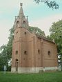
 St. Nicholas Church
 -
 St. Nicholas Church
 -
 Inside the St. Nicholas Church
 -
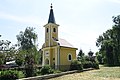 Chapel of the Holy Spring
 -
-
 The Fire Station of Csepreg
 -
 Flag of Csepreg
 -
 Lake Bene-hegy


References edit
- ^ = 81322&p_temakor_kod = KSH&p_session_id = 800051036609396&p_lang = EN Gazetteer of Hungary, 1st January 2015. Hungarian Central Statistical Office.
- ^ "Csepreg". Welcome to Hungary!. Compalmanach. Retrieved 2009-01-07.
- ^ "Land use planning of a mixed industrial-dwelling area" (pdf). Participation Exercise. unece. Retrieved 2009-01-07.
External links edit
- Street map (in Hungarian)