


Summary
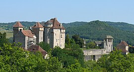
Curemonte (French pronunciation: [kyʁmɔ̃t]; Limousin: Curamonta) is a commune in the Corrèze department in central France. It is a medieval village characterised by its three castles. In a fortified position on a ridge overlooking a valley on both its eastern and western flanks, the village has historically had a strategic importance in the area. Its inhabitants are called Curemontois.
Curemonte | |
|---|---|
 The Château des Plas, in Curemonte | |
 Coat of arms | |
Location of Curemonte .mw-parser-output .locmap .od{position:absolute}.mw-parser-output .locmap .id{position:absolute;line-height:0}.mw-parser-output .locmap .l0{font-size:0;position:absolute}.mw-parser-output .locmap .pv{line-height:110%;position:absolute;text-align:center}.mw-parser-output .locmap .pl{line-height:110%;position:absolute;top:-0.75em;text-align:right}.mw-parser-output .locmap .pr{line-height:110%;position:absolute;top:-0.75em;text-align:left}.mw-parser-output .locmap .pv>div{display:inline;padding:1px}.mw-parser-output .locmap .pl>div{display:inline;padding:1px;float:right}.mw-parser-output .locmap .pr>div{display:inline;padding:1px;float:left}html.skin-theme-clientpref-night .mw-parser-output .od,html.skin-theme-clientpref-night .mw-parser-output .od .pv>div,html.skin-theme-clientpref-night .mw-parser-output .od .pl>div,html.skin-theme-clientpref-night .mw-parser-output .od .pr>div{background:#000;color:#fff}html.skin-theme-clientpref-night .mw-parser-output .locmap{filter:grayscale(0.6)}@media(prefers-color-scheme:dark){html.skin-theme-clientpref-os .mw-parser-output .locmap{filter:grayscale(0.6)}html.skin-theme-clientpref-os .mw-parser-output .od,html.skin-theme-clientpref-os .mw-parser-output .od .pv>div,html.skin-theme-clientpref-os .mw-parser-output .od .pl>div,html.skin-theme-clientpref-os .mw-parser-output .od .pr>div{background:#000;color:#fff}}  Curemonte  Curemonte | |
| Coordinates: 45°00′00″N 1°44′27″E / 44.9999°N 1.7409°E | |
| Country | France |
| Region | Nouvelle-Aquitaine |
| Department | Corrèze |
| Arrondissement | Brive-la-Gaillarde |
| Canton | Midi Corrézien |
| Intercommunality | Midi Corrézien |
| Government | |
| • Mayor (2020–2026) | Nelly Germane[1] |
| Area 1 | 8.83 km2 (3.41 sq mi) |
| Population (2021)[2] | 212 |
| • Density | 24/km2 (62/sq mi) |
| Time zone | UTC+01:00 (CET) |
| • Summer (DST) | UTC+02:00 (CEST) |
| INSEE/Postal code | 19067 /19500 |
| 1 French Land Register data, which excludes lakes, ponds, glaciers > 1 km2 (0.386 sq mi or 247 acres) and river estuaries. | |
Toponymy edit
The name for Curemonte is derived from low Latin Cura montis meaning a location used for an operating estate that's on a mountain or hill.[3]: 25
History edit
The existence of Curemonte is confirmed from as early as 860 when it was mentioned in the Cartulaire de l'Abbaye de Beaulieu.[3]: 25 Rodolphe de Turenne, Archbishop of Bourges, had donated the village of Saint-Genst and its vineyards at Curemonte to the Abbey of Beaulieu.[3]: 25
It was in the 11th century that the village flourished, passing through the Viscounts of Turenne.
Geography edit
Location edit
The municipality of Curemonte is located at the southern end of the department of Corrèze.

Physical geography edit
The village of Curemonte is built on a ridge line that overlooks the valleys of the Sourdoire and the Maumont.
Demographics edit
| Year | Pop. | ±% p.a. |
|---|---|---|
| 1968 | 311 | — |
| 1975 | 248 | −3.18% |
| 1982 | 231 | −1.01% |
| 1990 | 203 | −1.60% |
| 1999 | 225 | +1.15% |
| 2009 | 213 | −0.55% |
| 2014 | 216 | +0.28% |
| 2020 | 208 | −0.63% |
| Source: INSEE[4] | ||
Places and monuments edit
- It is ranked among the most beautiful villages in France.
- It has three castles:
- It has three churches:
- Church of Saint-Barthélemy du Bourg;
- Church of Saint-Hilaire de la Combe: 11th Century Romanesque church, one of the oldest in the department, which was probably built on Merovingian foundations;
- The church of Saint-Genest: former parish church, now a Museum of Religious Art.
-
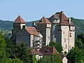 Châteaux de Plas et de Saint-Hilaire.
 -
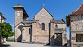 Church of Saint-Barthélemy.
 -
 Church of Saint-Hilaire de la Combe.


See also edit
References edit
- ^ "Répertoire national des élus: les maires". data.gouv.fr, Plateforme ouverte des données publiques françaises (in French). 9 August 2021.
- ^ "Populations légales 2021". The National Institute of Statistics and Economic Studies. 28 December 2023.
- ^ a b c Lalé, Jean (1994). Curemonte. Chronique d'une Renaissance (in French). Treignac: Les Monédières. ISBN 2-903438-11-X. OCLC 12134959.
{{cite book}}: Check|isbn=value: checksum (help) - ^ Population en historique depuis 1968, INSEE
- ^ Base Mérimée: Châteaux de Saint-Hilaire et des Plas, Ministère français de la Culture. (in French)
- ^ Base Mérimée: Château de la Johannie, Ministère français de la Culture. (in French)