
KNOWPIA
WELCOME TO KNOWPIA

Curitibanos 
Summary
Curitibanos is a Brazilian municipality in the state of Santa Catarina. It is located at 27º16'58" south latitude and 50º35'04" west longitude, at an elevation of 987 metres. It has an area of 953.67 km² and its population, according to 2018 IBGE estimates, was 39,595 inhabitants.
Curitibanos | |
|---|---|
 Church in Curitibanos | |
 Flag  Seal | |
| Nickname: Ame Curitibanos (Love Curitibanos) | |
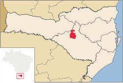 Location of Curitibanos | |
 Curitibanos | |
| Coordinates: 27°18′00″S 50°34′30″W / 27.30000°S 50.57500°W | |
| Country | |
| Region | South |
| State | |
| Founded | June 11, 1869 |
| Government | |
| • Mayor | Kleberson Luciano Lima[1] (PMDB) |
| Area | |
| • Total | 952.283 km2 (367.679 sq mi) |
| Elevation | 987 m (3,238 ft) |
| Population (2020 [2]) | |
| • Total | 39,893 |
| • Density | 40.0/km2 (104/sq mi) |
| Time zone | UTC-3 (UTC-3) |
| • Summer (DST) | UTC-2 (UTC-2) |
| HDI (2000) | 0.769 |
| Website | www.curitibanos.sc.gov.br |
Climate edit
Curitibanos has oceanic climate (Köppen climate classification: Cfb) on summer the temperature reaches 25 °C, on winter it reaches 7 °C, rarely falling below 0 °C or exceeding 13 °C. The highest temperature was 34 °C. The lowest temperature was -5 °C. Frost are common on winter.
See also edit
References edit
External links edit
 Curitibanos travel guide from Wikivoyage