


Summary
Curlwaa is a locality in New South Wales, Australia.[2]
| Curlwaa New South Wales | |
|---|---|
 | |
 Curlwaa | |
| Coordinates | 34°06′S 141°58′E / 34.100°S 141.967°E |
| Population | 393 (2016 census)[1] |
| Postcode(s) | 2648 |
| Location | 4 km (2 mi) east of Wentworth |
| LGA(s) | Wentworth Shire |
| State electorate(s) | Murray |
| Federal division(s) | Farrer |
Curlwaa is an irrigation settlement a few kilometres upstream of Wentworth on the Murray River in far southwestern New South Wales. It is the first Government irrigation scheme in New South Wales, established in 1890.
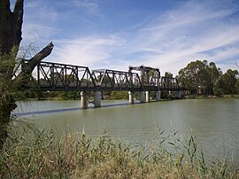
Abbotsford Bridge edit
The Abbotsford Bridge spans the Murray River between Yelta, Victoria and Curlwaa, New South Wales. It is the northernmost point to cross the River as well as the final crossing point before the South Australia border, approximately 109 kilometers (67 miles) to the west. The name, Abbotsford, is derived from the punt service that previously operated at the site of the bridge. This was known as Abbot's Ford. Over time, this area of the river northwest of Merbein became known as Abbotsford.
The bridge was opened on 10 July 1928 by the Admiral Sir Dudley de Chair KCB KBE MVO, Governor of New South Wales.
References edit
- ^ Australian Bureau of Statistics (25 October 2007). "Curlwaa (Suburb)". 2006 Census QuickStats. Retrieved 9 October 2008.
- ^ "Curlwaa a small Murray River town near Wentworth, NSW". www.murrayriver.com.au. Retrieved 12 May 2021.
External links edit
![]() Media related to Curlwaa, New South Wales at Wikimedia Commons
Media related to Curlwaa, New South Wales at Wikimedia Commons