
KNOWPIA
WELCOME TO KNOWPIA

Cuverville, Seine-Maritime 
Summary
Cuverville (French pronunciation: [kyvɛʁvil] ⓘ) is a commune in the Seine-Maritime department in the Normandy region in northern France.
Cuverville | |
|---|---|
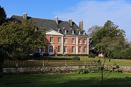 The chateau in Cuverville | |
 Coat of arms | |
Location of Cuverville .mw-parser-output .locmap .od{position:absolute}.mw-parser-output .locmap .id{position:absolute;line-height:0}.mw-parser-output .locmap .l0{font-size:0;position:absolute}.mw-parser-output .locmap .pv{line-height:110%;position:absolute;text-align:center}.mw-parser-output .locmap .pl{line-height:110%;position:absolute;top:-0.75em;text-align:right}.mw-parser-output .locmap .pr{line-height:110%;position:absolute;top:-0.75em;text-align:left}.mw-parser-output .locmap .pv>div{display:inline;padding:1px}.mw-parser-output .locmap .pl>div{display:inline;padding:1px;float:right}.mw-parser-output .locmap .pr>div{display:inline;padding:1px;float:left}html.skin-theme-clientpref-night .mw-parser-output .od,html.skin-theme-clientpref-night .mw-parser-output .od .pv>div,html.skin-theme-clientpref-night .mw-parser-output .od .pl>div,html.skin-theme-clientpref-night .mw-parser-output .od .pr>div{background:#000;color:#fff}html.skin-theme-clientpref-night .mw-parser-output .locmap{filter:grayscale(0.6)}@media(prefers-color-scheme:dark){html.skin-theme-clientpref-os .mw-parser-output .locmap{filter:grayscale(0.6)}html.skin-theme-clientpref-os .mw-parser-output .od,html.skin-theme-clientpref-os .mw-parser-output .od .pv>div,html.skin-theme-clientpref-os .mw-parser-output .od .pl>div,html.skin-theme-clientpref-os .mw-parser-output .od .pr>div{background:#000;color:#fff}}  Cuverville  Cuverville | |
| Coordinates: 49°39′52″N 0°15′48″E / 49.6644°N 0.2633°E | |
| Country | France |
| Region | Normandy |
| Department | Seine-Maritime |
| Arrondissement | Le Havre |
| Canton | Octeville-sur-Mer |
| Intercommunality | Le Havre Seine Métropole |
| Area 1 | 4.58 km2 (1.77 sq mi) |
| Population (2021)[1] | 342 |
| • Density | 75/km2 (190/sq mi) |
| Time zone | UTC+01:00 (CET) |
| • Summer (DST) | UTC+02:00 (CEST) |
| INSEE/Postal code | 76206 /76280 |
| Elevation | 32–130 m (105–427 ft) (avg. 99 m or 325 ft) |
| 1 French Land Register data, which excludes lakes, ponds, glaciers > 1 km2 (0.386 sq mi or 247 acres) and river estuaries. | |
Geography edit
A small farming village situated in the Pays de Caux, some 13 miles (21 km) northeast of Le Havre, on the D239 road.
Population edit
| Year | Pop. | ±% p.a. |
|---|---|---|
| 1968 | 169 | — |
| 1975 | 148 | −1.88% |
| 1982 | 187 | +3.40% |
| 1990 | 231 | +2.68% |
| 1999 | 292 | +2.64% |
| 2007 | 325 | +1.35% |
| 2012 | 360 | +2.07% |
| 2017 | 351 | −0.51% |
| Source: INSEE[2] | ||
Places of interest edit
Notable people edit
- André Gide is buried here.
See also edit
References edit
- ^ "Populations légales 2021". The National Institute of Statistics and Economic Studies. 28 December 2023.
- ^ Population en historique depuis 1968, INSEE
Wikimedia Commons has media related to Cuverville (Seine-Maritime).