


Summary
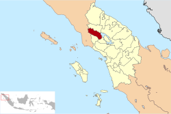
Dairi Regency is an inland regency on the western shore of Lake Toba in North Sumatra Province of Indonesia. The regency was created on 23 September 1964 from what were previously the north-western districts of North Tapanuli Regency; however the southern districts of this new regency were in turn split off on 25 February 2003 to form the new Pakpak Bharat Regency. The reduced regency covers an area of 1,927.80 square kilometres (744.33 sq mi) and it had a population of 269,848 people at the 2010 Census[2] and 308,764 at the 2020 Census;[3] the official estimate as at mid 2023 was 324,747 - comprising 162,928 males and 161,819 females.[1] Its administrative seat is at the town of Sidikalang.
Dairi Regency | |
|---|---|
 Regent's office of Dairi Regency | |
 Coat of arms | |
 | |
| Country | Indonesia |
| Province | North Sumatra |
| Regency seat | Sidikalang |
| Government | |
| • Regent | Eddy Keleng Ate Berutu |
| • Vice Regent | Jimmy Andrea Lukita Sihombing |
| • Chairman of Council of Representatives | Sabam Sibarani (Golkar) |
| • Vice Chairmen of Council of Representatives | Alvensius Tondang (PDI-P) and Wanseptember Situmorang (Partai Demokrat) |
| Area | |
| • Total | 1,927.80 km2 (744.33 sq mi) |
| Population (mid 2023 estimate)[1] | |
| • Total | 324,747 |
| • Density | 170/km2 (440/sq mi) |
| Time zone | UTC+7 (WIB) |
| Website | www |
Geography and climate edit
Dairi is mostly hills and mountains, averaging 700 to 1,250 metres (2,300 to 4,100 ft) above sea level. It has a tropical rainforest climate, with the heaviest rainfall between September and May.[4]
Demographics edit

A 2008 estimate by the Dairi government put Dairi's population at 271,983, with a sex ratio of 99.43. Of the population, 39.96% is under the age of 14.[5] At the 2010 Census the population was 269,848,[2] at the 2020 Census it was 308,764[3] and for mid 2023 it was estimated as 324,747.[1]
Bordering territories edit
The Dairi Regency is bordered to the north by Karo Regency, to the east by Samosir Regency and Lake Toba, to the south by Pakpak Bharat Regency, and to the west by Aceh Province (Southeast Aceh Regency and the City of Subulussalam).
Administrative districts edit
Dairi Regency is divided into fifteen districts (kecamatan), tabulated below with their areas and their populations at the 2010 Census[2] and the 2020 Census,[3] together with the official estimates as at mid 2023.[1] The table also includes the locations of the district administrative centres, the number of administrative villages in each district (totaling 161 rural desa and 8 urban kelurahan), and its post code.
| Kode Wilayah |
Name of District (kecamatan) |
Area in km2 |
Pop'n Census 2010 |
Pop'n Census 2020 |
Pop'n Estim. mid 2023 |
Admin centre |
No. of villages |
Post code |
|---|---|---|---|---|---|---|---|---|
| 12.11.01 | Sidikalang | 70.67 | 48,646 | 53,433 | 56,498 | Sidikalang | 11 (a) | 22211 -22219 |
| 12.11.13 | Berampu | 40.85 | 7,908 | 9,031 | 9,396 | Berampu | 5 | 22251 |
| 12.11.15 | Sitinjo | 53.15 | 11,235 | 14,429 | 15,211 | Sitinjo | 4 (b) | 22219 |
| 12.11.10 | Parbuluan | 235.40 | 20,637 | 25,236 | 27,203 | Sigalingging | 11 | 22282 |
| 12.11.02 | Sumbul | 192.58 | 39,365 | 45,606 | 47,224 | Sumbul | 19 (c) | 22284 |
| 12.11.14 | Silahisabungan | 75.62 | 4,471 | 5,242 | 5,811 | Silalahi | 5 | 22280 |
| 12.11.05 | Silima Pungga-Pungga | 88.35 | 12,651 | 14,448 | 15,318 | Parongil | 16 (d) | 22262 |
| 12.11.11 | Lae Parira | 42.75 | 13,567 | 14,526 | 15,442 | Lae Parira | 9 | 22281 |
| 12.11.04 | Siempat Nempu | 60.15 | 17,979 | 20,241 | 21,091 | Buntu Raja | 13 | 22261 |
| 12.11.07 | Siempat Nempu Hulu (Upper Siempat Nempu) |
93.93 | 17,663 | 20,183 | 20,993 | Silumboyah | 12 | 22254 |
| 12.11.08 | Siempat Nempu Hilir (Lower Siempat Nempu) |
105.62 | 10,423 | 11,746 | 12,346 | Sopobutar | 10 | 22263 |
| 12.11.03 | Tigalingga | 197.00 | 21,444 | 24,428 | 25,333 | Tigalingga | 14 | 22252 |
| 12.11.12 | Gunung Sitember |
77.00 | 9,090 | 10,714 | 11,081 | Gunung Sitember |
8 | 22250 |
| 12.11.09 | Pegagan Hilir (Lower Pegagan) |
155.33 | 14,740 | 16,740 | 17,933 | Tiga Baru | 13 | 22283 |
| 12.11.06 | Tanah Pinem | 439.40 | 20,234 | 22,761 | 23,867 | Kuta Buluh | 19 | 22253 |
| Totals | 1,927.80 | 269,848 | 308,764 | 324,747 | Sidikalang | 169 |
Notes: (a) comprising 5 kelurahan (Batang Beruh, Bintang Hulu, Kuta Gambir, Sidiangkat and Sidikalang Kota) and 6 desa.
(b) including the kelurahan of Panji Dabutar. (c) including the kelurahan of Pegagan Julu I. (d) including the kelurahan of Parongil.
Coat of arms edit
The coat of arms of Dairi has many connotations. Indonesia's date of independence, 17 August 1945, is indicated by the 17-budded cotton plant on the left side, 8 rattan branches in the center, and 45 seeds of rice on a stalk to the right. The shield in the centre is divided into five, four parts indicating different cash crops important to the area (benzoin resin, coffee, tobacco and patchouli), while the fifth shows a traditional Pakpak Batak house; the house signifies protection. The five point star in the top center signifies the Pancasila-respecting habits of the Dairi people, while the mountains represent tranquility and the chains represent gotong royong, or cooperating and collaborating. The central sharpened bamboo spear represents the Dairi people's struggle for independence.[6]
History edit

Prior to the arrival of the Dutch East India Company, the people of what is now Dairi lived in traditional adat-regulated communities, with unelected local leaders. After the arrival of the Dutch they established an ethnic-Dutch controleur to be in charge of the Dairi onder afdeling, as well as a native Indonesian demang, or lieutenant. When the Japanese occupied Indonesia beginning in 1942, the Dairi area was also occupied; during this time, local youths were used as forced labour to build the 65 kilometres (40 mi) long Sidikalang road and the Dutch were removed.[7]
After Indonesia's independence, the residents attempted to build a foundation for a new government. However, after the Dutch army recaptured nearby East Sumatra in 1947, they chose a new leader for the Dairi area. Another leader was chosen in 1949; later that year, after the Netherlands and Indonesia signed an agreement for Indonesian independence [7]
Economy edit
Farming is a large business in Dairi. Major crops in Dairi are coffee, both robusta and arabica, corn, and potatoes. Approximately 6,770 tonnes of robusta coffee are produced every year, in addition to 2,639 tonnes of arabica; corn fields take up 63% of suitable farming land.[8] Other minor trades are damar collecting, fish farming, and rattan.[9]
Since 1997, Dairi Prima Mineral have operated the Dairi mine near the Sopokomil hamlet of Longkotan [id] village[10] in the Silima Pungga-Pungga [id] subdistrict of the regency.[11][12]
References edit
- ^ a b c d Badan Pusat Statistik, Jakarta, 28 February 2024, Kabupaten Dairi Dalam Angka 2024 (Katalog-BPS 1102001.1211)
- ^ a b c Biro Pusat Statistik, Jakarta, 2011.
- ^ a b c Badan Pusat Statistik, Jakarta, 2021.
- ^ Dairi Government, Geografi.
- ^ Dairi Government, Demografi.
- ^ Dairi Government, Lambang.
- ^ a b Dairi Government, History.
- ^ North Sumatra, Dairi.
- ^ Dairi Government, Sosiologi.
- ^ Niranjan, Ajit; Nugraha, Rizki (6 February 2021). "Proposed Indonesian zinc mine 'almost certain' to collapse". DW News. Archived from the original on 19 August 2022. Retrieved 10 April 2023.
- ^ "RESOURCES AND RESERVES, DAIRI ZINC PROJECT" (PDF). 2012. Archived (PDF) from the original on 7 February 2020. Retrieved 10 July 2013.
- ^ Simangunsong, Tonggo (12 January 2023). "Indonesian government accused of putting lives at risk with zinc mine permit". The Guardian. ISSN 0261-3077. Archived from the original on 22 March 2023. Retrieved 10 April 2023.
- Bibliography
- "Demografi" [Demography] (in Indonesian). Government of Dairi Regency. Archived from the original on 27 July 2012. Retrieved 23 August 2011.
- "Geografi" [Geography] (in Indonesian). Government of Dairi Regency. Archived from the original on 27 July 2012. Retrieved 23 August 2011.
- "Kabupaten Dairi" [Dairi Regency] (in Indonesian). Government of North Sumatra. Archived from the original on 17 February 2009. Retrieved 23 August 2011.
- "Lambang Daerah" [Area Coat of Arms] (in Indonesian). Government of Dairi Regency. Archived from the original on 27 July 2012. Retrieved 23 August 2011.
- "Sejarah" [History] (in Indonesian). Government of Dairi Regency. Archived from the original on 4 October 2011. Retrieved 23 August 2011.
- "Profil Pemerintah Kabupaten Dairi" [Profile of the Dairi Regency Government] (in Indonesian). Government of Dairi Regency. Archived from the original on 27 July 2012. Retrieved 23 August 2011.
- "Sosiologi" [Sociology] (in Indonesian). Government of Dairi Regency. Archived from the original on 28 July 2012. Retrieved 23 August 2011.
3°00′00″N 99°10′00″E / 3°N 99.1667°E