


Summary
Dalby (/ˈdɒlbi/)[2] is a rural town and locality in the Western Downs Region, Queensland, Australia.[3][4] In the 2021 census, the locality of Dalby had a population of 12,082 people.[5]
| Dalby Queensland | |||||||||||||||
|---|---|---|---|---|---|---|---|---|---|---|---|---|---|---|---|
  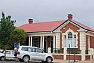  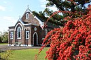 (From left to right) Aerial view of Dalby, Dalby Council Chambers, Dalby Court House, Lake Broadwater, St John's Anglican Church | |||||||||||||||
 Dalby | |||||||||||||||
| Coordinates | 27°10′53″S 151°15′58″E / 27.1813°S 151.2661°E | ||||||||||||||
| Population | 12,082 (2021 census)[1] | ||||||||||||||
| • Density | 37.313/km2 (96.641/sq mi) | ||||||||||||||
| Postcode(s) | 4405 | ||||||||||||||
| Elevation | 344 m (1,129 ft) | ||||||||||||||
| Area | 323.8 km2 (125.0 sq mi) | ||||||||||||||
| Time zone | AEST (UTC+10:00) | ||||||||||||||
| Location |
| ||||||||||||||
| LGA(s) | Western Downs Region | ||||||||||||||
| State electorate(s) | Warrego | ||||||||||||||
| Federal division(s) | Maranoa | ||||||||||||||
| |||||||||||||||
| |||||||||||||||
It is on the Darling Downs and is the administrative centre for the Western Downs Region.
Geography edit
Dalby is approximately 82.3 kilometres (51.1 miles) west of Toowoomba, 208 kilometres (129 mi) west northwest of the state capital, Brisbane, 269 kilometres (167 miles) east southeast of Roma and 535 kilometres (332 miles) east southeast of Charleville at the junction of the Warrego, Moonie and Bunya Highways.[6] State Route 82 also passes through Dalby. It enters from the north as Dalby–Jandowae Road and exits to the south as Dalby–Cecil Plains Road. Dalby–Cooyar Road exits to the east.[7] Dalby is the centre of Australia's richest grain and cotton growing area.[6]
Transport edit
Western railway line edit
The Western railway line passes through Dalby with a number of railway stations serving the locality:
- Baining railway station (27°06′37″S 151°10′05″E / 27.1103°S 151.1681°E)[8]
- Yarrala railway station, now closed (27°07′28″S 151°11′19″E / 27.1244°S 151.1887°E)[8]
- Tycanba railway station (27°09′57″S 151°14′57″E / 27.1659°S 151.2491°E)[8]
- Dalby railway station in Hunter Street (27°10′48″S 151°16′17″E / 27.1799°S 151.2715°E) serving the town[8]
- Blaxland railway station (27°11′47″S 151°19′10″E / 27.1963°S 151.3195°E)[8]
Glenmorgan railway line edit
The Glenmorgan railway line branches from the Western railway line just west of the Dalby railway station with the following railway stations within the locality of Dalby":
- Yumborra railway station, now closed (27°10′57″S 151°14′19″E / 27.1826°S 151.2387°E)[8]
- Dalby West railway station (27°10′52″S 151°14′44″E / 27.1812°S 151.2456°E)[8]
- Natcha railway station, serving the Dalby Butter Factory, now closed (27°10′42″S 151°15′13″E / 27.1783°S 151.2536°E)[8][9][10]
Bell Branch railway line edit
The now-closed Bell Branch railway line also branched from the Western railway line with the following railway stations within the locality of Dalby:
- Bonyumba railway station (27°10′08″S 151°16′45″E / 27.1689°S 151.2793°E)[8]
- Sanatorium railway station, serving the Dalby Sanatorium (27°09′20″S 151°17′35″E / 27.1556°S 151.2930°E)[8]
- Mocattas Corner railway station (27°06′57″S 151°21′46″E / 27.1159°S 151.3629°E)[8]
Airports edit
Dalby Aerodrome is an airport (27°09′39″S 151°15′51″E / 27.1607°S 151.2642°E).[11]
There is a heliport at Dalby Hospital (27°10′02″S 151°16′37″E / 27.1671°S 151.2769°E).[12]
History edit

Baranggum (also known as Barrunggam, Barunggam Parrungoom and Murrumgama) is an Australian Aboriginal language spoken by the Baranggum people. The Baranggum language region includes the landscape within the local government boundaries of the Western Downs Regional Council, particularly Dalby, Tara, Jandowae and west towards Chinchilla.[13]
Dalby was founded in the early 1840s at a place known locally as "The Crossing" on Myall Creek, a tributary of the Condamine River. The first settler was Henry Dennis, who explored the region and chose land for himself and others in the locality.[14] Today an obelisk in Edward Street denotes the location where Dennis camped.[6]
A small settlement was founded to assist travellers heading north to nearby Jimbour Station. The explorer Ludwig Leichhardt visited the area in 1844, on his way to Port Essington.[15]
In February 1853, the New South Wales government sent the Deputy Surveyor General Captain Samuel Perry to the area to survey a township. In August of the following year, Charles Douglas Eastaughffe arrived with a document under the Seal of the NSW Government officially proclaiming 'Dalby' a township. Eastaughffe was later appointed Chief Constable and remained in Dalby until his retirement.[16]
The name of the town is believed to come from the village of Dalby on the Isle of Man and reflects immigration from the Isle of Man in the mid-19th century.[14] The name was apparently chosen by Captain Samuel Perry when he surveyed the settlement in 1853.
Myall Creek Post Office also opened in 1854 in Roche's store, with Mr. Simpson as the first postmaster. It was renamed Dalby in 1855.[15][17]
In 1859, Dalby became part of the new Colony of Queensland.

Dalby State School opened on 1 June 1861. In 1869, the school split into Dalby Boys State School Dalby Girls State School. In 1885, the girls' school became Dalby Girls & Infants State School. In 1893, the two schools were combined as Dalby State School. In 1914, the school expanded to include a secondary school, which closed in 1954, due to the establishment of a separate secondary school, Dalby State High School.[18][19]
In August 1863, Dalby was officially proclaimed a municipality, the Borough of Dalby, in the Queensland Government Gazette.
Dalby Non-Vested School opened as a Roman Catholic girls school in 1864 and in 1866 became a non-vested school (the teachers' salaries were paid by the Queensland Government but the government did not operate the school). Circa 1880, the school either closed or continued without government funding.[18]
On Sunday 5 August 1866, Bishop James Quinn dedicated St Joseph's Catholic Church.[20]
Dalby was linked by the Western railway line to Ipswich on 16 April 1868.[21]
On Sunday 20 June 1869, the first Presbyterian church was opened in Dalby.[22] Reverend George Grimm had conducting regular services since 1865.[23]
St Columba's School was a Catholic primary school which was opened in 1877 by the Sisters of Mercy. In 2008, it merged with St Mary's College to create Our Lady of the Southern Cross College.[18]
From 1873 to 1949, the electoral district of Dalby was an electoral district of the Legislative Assembly of Queensland.
Dalby was believed to have a healthy climate and in October 1900 the Queensland Government opened the Jubilee Sanitorium for consumptive patients. The name Jubilee commemorates the Diamond Jubilee of Queen Victoria.[24][25] In 1904 the Dalby Town Council erected therapeutic thermal baths using artesian water from a local bore for those wishing to improve their health by "taking the waters".[26] In 1938, the council closed the artesian baths as interest in "taking the waters" was declining. Medical opinion became increasingly doubtful of the benefits of bathing in mineral waters, favouring drugs and physiotherapy as better treatments.[27] It closed in January 1938 with its remaining patients transferred to Westwood Sanatorium.[25][28]
Kincora Provisional School opened in 1908 "via Dalby" and was renamed Moonie River Provisional School circa December 1908. It closed circa 1916.[29]

On 8 December 1912, the Dalby Methodist Church in Condamine Street was officially opened by the Reverend Henry Youngman, the President of the Queensland Methodist Conference.[30][31][32] In March 1949 it was announced that a new church would be built with the original church to be moved on the site and be used as a church hall.[33] On 1 October 1949 the foundation stone for the new Dalby Methodist Church was laid by Reverend Henry William Prouse, the President of the Queensland Methodist Conference.[34][35][36][37] Construction commenced in May 1950, but there were delays in obtaining building materials until August 1951.[38][39] The new church was dedicated on Saturday 8 December 1951 by Reverend Tom Hardy Blackburn.[40][41] When the Methodist Church amalgamated into the Uniting Church in Australia in 1977, it became the Dalby Uniting Church.[37]
The Dalby War Memorial was unveiled by the Queensland Governor, Matthew Nathan, on 26 July 1922.[42]

The Paragon Cafe was purchased in 1935 by Milton (Miltiadis) Dimitrios Samios part of the cultural phenomenon of Greek cafes in Queensland. Paragon Cafe employed three men and six women with taking increasing from 90 pounds to 200 pounds within the first year of trading.[43]
The Dalby Olympic Swimming Pool complex was constructed in 1936 and is the earliest identified Olympic standard pool in Queensland constructed outside Brisbane.
Dalby State High School opened on 2 February 1954.[18][44] Bunya Campus was acquired by Dalby State High School at the start of 2011 and has since provided students who live out of the catchment area the opportunity to attend Dalby State High School and participate in all it has to offer as a boarding student.[45]
St Mary's College was a Catholic secondary school opened on 21 January 1963 by the Christian Brothers. In 2008, it merged with St Columba's School to create Our Lady of the Southern Cross College.[18]
Dalby South State School opened on 29 March 1965.[18][46]
Dalby Christian School was opened on 1 February 1981 by the Dalby Gospel Chapel.[18][47]
The Christian Outreach College opened on 28 January 1984. It closed on 18 September 1991.[18]
In 2004, Dalby began treating its water with state-of-the-art reverse osmosis process. The first Reverse Osmosis plant, opened in 2004, was the first in Queensland.[48] The second and larger plant opened in 2011.[49]
In 2006, the opening of Dalby Shoppingworld at the northern end of Cunningham Street has brought new life to the Dalby CBD. The centre includes Woolworths, Big W, Amcal and other specialty shops.[50] As part of nationwide restructuring, Target Country closed its store in January 2021 and was replaced by K Hub, which opened in February.
Dalby Library opened in 2014.[51]
In 2016, Dalby's population was increasing rapidly with many new estates created and subdivisions made.[52] Some notable new estates include Sunnyside Estate, Heritage Gardens, Callistemon Park and a new estate on the Warrego Highway side of Sandalwood Avenue.
Demographics edit
In the 2016 census, the locality of Dalby had a population of 12,719 people.[53] Aboriginal and Torres Strait Islander people made up 7.0% of the population. 84.0% of people were born in Australia. The next most common countries of birth were Philippines 1.9%, New Zealand 1.3%, England 1.1% and South Africa 0.8%. 88.7% of people spoke only English at home. Other languages spoken at home included Tagalog at 1.0%. The most common responses for religion were Catholic 26.3%, Anglican 19.6% and No Religion 16.9%.[53]
In the 2021 census, Dalby's population fell to 12,082 people.[5]
Heritage listings edit

Dalby has a number of heritage-listed sites, including:
- 133 Cunningham Street: former Dalby Town Council Chambers and Offices[54]
- 153 Cunningham Street: St John's Anglican Church[55]
- 169 Cunningham Street: St Columba's Convent[56]
- 21 New Street: Dalby Fire Station[57]
- 28B Nicholson Street: Dalby State High School[58]
- Patrick Street: Dalby War Memorial and Gates[59]
- 58 Patrick Street: Dalby Olympic Swimming Pool[60]
Economy edit
Industry in Dalby includes large-scale engineering, coal mining, and fuels (ethanol). Dalby is the centre of a diverse and productive agricultural area with rich black soil allowing the production of crops such as wheat, cotton and sorghum. Livestock raising including pigs, cattle and sheep is also popular. Two cotton gins are situated within 10 kilometres (6 mi) of the town.
Dalby is to be the site of the first dry mill grain-to-ethanol plant constructed in Australia (the first plant built specifically for the production of ethanol for fuel since World War II).[61]
Power edit
The local area is developing an energy-based economy with a large coal-fired power station and a number of coal mines and natural gas bores being established to the west of Dalby. A local company has been awarded a contract to establish wind turbines on adjacent farm land.[citation needed]
Approximately 50 kilometres (31 mi) west of Dalby is the Kogan Creek Power Station. This A$1.2 billion project is a 750-megawatt coal-fired power station, with adjacent coal mine being developed at the small town of Kogan, which is roughly equidistant between Dalby, Chinchilla, and Tara.
Education edit

Dalby State School is a government primary (Preparatory to Year 6) school for boys and girls at 155 Cunningham Street (27°11′05″S 151°15′44″E / 27.1846°S 151.2623°E).[62][63] In 2017, the school had an enrolment of 579 students with 43 teachers (39 full-time equivalent) and 35 non-teaching staff (23 full-time equivalent) and has a special education program certified through the National Disability Insurance Scheme.[64] It is one of the oldest state primary schools in Queensland.[65]

Dalby South State School is a government primary (Early Childhood to Year 6) school for boys and girls at 65 Owen Street (corner of Bunya Street, 27°11′41″S 151°16′12″E / 27.1948°S 151.2701°E).[62][66] In 2017, the school had an enrolment of 653 students with 46 teachers (43 full-time equivalent) and 32 non-teaching staff (21 full-time equivalent).[64] It includes a special education program (Preparatory to Year 10) which is certified through the National Disability Insurance Scheme.[67]
Our Lady of the Southern Cross College is a Catholic primary and secondary (Preparatory to Year 12) school for boys and girls at 2 Nicholson Street (27°10′18″S 151°16′03″E / 27.1718°S 151.2676°E).[62][68] In 2017, the school had an enrolment of 594 students with 48 teachers (44 full-time equivalent) and 31 non-teaching staff (20 full-time equivalent).[64] It has a special education program certified through the National Disability Insurance Scheme.
Dalby Christian College is a private primary and secondary (Preparatory to Year 12) school for boys and girls at 2A Mary Street (27°10′20″S 151°16′41″E / 27.1722°S 151.2780°E).[62][69] It is operated by the Christian Community Ministries. In 2017, the school had an enrolment of 328 students with 25 teachers (24 full-time equivalent) and 17 non-teaching staff (13 full-time equivalent).[64] It has an early learning centre and boarding for secondary students as well as a special education program certified through the National Disability Insurance Scheme.[47][70]
Dalby State High School is a government secondary (7–12) school for boys and girls at 26 Nicholson Street (27°10′41″S 151°15′34″E / 27.1781°S 151.2595°E).[62][71] In 2017, the school had an enrolment of 1,040 students with 94 teachers (89 full-time equivalent) and 71 non-teaching staff (54 full-time equivalent).[64] It includes a special education program certified through the National Disability Insurance Scheme.[62][72] The school has a boarding facility for boys and girls at 463 Bunya highway (27°09′08″S 151°17′42″E / 27.1523°S 151.2949°E).[45][62][73] Many students from small towns surrounding Dalby (such as Jandowae and Warra) attend Dalby State High School, as these communities do not have schools which provide senior level education. The school also performs an annual musical, usually in late May, with performances running for a full week. It is produced and directed by teachers at the school and stars students from all year levels.
Local media edit
There are two locally published newspapers, the Dalby Herald and Northern Downs News, as well as the Dalby Magazine.[citation needed]
Dalby also has its own community radio station, 88.9 4DDD, which was founded on 26 January 1992.[74]
Dalby receives most commercial and ABC radio and television services from Toowoomba, the nearest regional city. Local news stories from Dalby and other Western Downs communities are often featured on WIN News, a regional television news bulletin compiled in Toowoomba.[citation needed]
Facilities edit
Water and sewerage treatment services are provided by Western Downs Regional Council. The town has made a ground-breaking deal with nearby gas companies by taking water from gas fields. It has been noted that the town will have a definite water supply for at least another 30 years, taking into account demographic trends.
There is also the Dalby Cemetery, a monumental cemetery.
Amenities edit
Western Downs Regional Council operates a public library at 107 Drayton Street.[75] It is open 10am to 5.30pm Monday to Friday and 10am to 12.30pm Saturday.[76] Dalby Library has two Creative Studios which have the latest in content creation tools, professional equipment and software, music production and recording, and digital production and editing to help create and share projects.[77]
St Mark's Lutheran Church is at 58A Condamine Street (27°10′50″S 151°15′48″E / 27.1806°S 151.2632°E).[78]
Dalby Uniting Church is at 71-73 Condamine Street (27°11′00″S 151°15′37″E / 27.1834°S 151.2604°E).[79][80]
The Springvale Kupunn branch of the Queensland Country Women's Association meets at 52 Cunningham Street.[81]
Sport edit
Dalby has a strong rugby League history with a senior rugby league team in the Toowoomba Rugby League known as The Dalby Diehard (founded 1980). The Junior Rugby League Team, The Dalby Devils, that participate in to Toowoomba Junior Rugby League.
Dalby has an Australian rules football team, the Dalby Swans (founded 1980) based at the Dalby AFL oval which fields men's, women's and junior teams in the AFL Darling Downs competition. It has produced top level players like Zimmorlei Farquharson.[82]
Condamine, 124 kilometres away has a rugby union team which compete in the Darling Downs Rugby Union competition, against such teams as the University of Southern Queensland Rugby Union Club, Toowoomba Rangers Rugby Union Club, Toowoomba City Rugby Club, Roma Echidnas, the Condamine Cods, the Dalby Wheatmen, the Goondiwindi Emus, the Warwick Water Rats and the University of Queensland Rugby Union Club (Gatton Campus).
Attractions edit

Dalby has a monument to the Cactoblastis cactorum in a park by the Myall Creek which runs through the town. The Argentinian caterpillar successfully eradicated the prickly pear in the 1920s.[6]
Climate edit
Dalby has a humid subtropical climate (Cfa in the Köppen climate classification) and being located just to the west of the Great Dividing Range it is hotter and less humid in summer and colder and drier in winter than nearby locations on the other side of the range. Dalby has had a recording weather station since 1893, but that was replaced in 1992 by another station at the Dalby Airport. The town's highest recorded temperature was 45.6 °C (114.1 °F) on 4 December 1913, while the coldest was −7.2 °C (19.0 °F) on 5 July 1895.[83] The annual rainfall is 681.2 mm (26.82 in), the majority of which falls as thunderstorms in the summer months.
Dalby experienced its worst floods since 1981 in late December 2010.[84] The town's water purification system was flooded, resulting in water restrictions that have hampered clean-up efforts. 112,500 litres (24,700 imp gal; 29,700 US gal) of water were transported to the town of 14,000 residents.[85] In early March 2013, Dalby received another severe flood, cutting the town in two after 122 mm (4.8 in) of rain was recorded over a few days. Flood waters peaked at 3.21 metres and a number of homes received water damage.[86]
| Climate data for Dalby Airport (1992–2022, 344 m AMSL) | |||||||||||||
|---|---|---|---|---|---|---|---|---|---|---|---|---|---|
| Month | Jan | Feb | Mar | Apr | May | Jun | Jul | Aug | Sep | Oct | Nov | Dec | Year |
| Record high °C (°F) | 42.6 (108.7) |
43.0 (109.4) |
40.2 (104.4) |
35.2 (95.4) |
32.9 (91.2) |
31.1 (88.0) |
27.4 (81.3) |
34.2 (93.6) |
38.4 (101.1) |
39.5 (103.1) |
41.3 (106.3) |
42.1 (107.8) |
43.0 (109.4) |
| Mean daily maximum °C (°F) | 32.6 (90.7) |
31.6 (88.9) |
30.2 (86.4) |
27.3 (81.1) |
23.3 (73.9) |
20.1 (68.2) |
19.9 (67.8) |
21.9 (71.4) |
25.7 (78.3) |
28.5 (83.3) |
30.6 (87.1) |
31.8 (89.2) |
27.0 (80.5) |
| Mean daily minimum °C (°F) | 18.8 (65.8) |
18.4 (65.1) |
16.6 (61.9) |
12.5 (54.5) |
8.9 (48.0) |
5.5 (41.9) |
4.1 (39.4) |
4.6 (40.3) |
8.7 (47.7) |
12.7 (54.9) |
15.6 (60.1) |
17.7 (63.9) |
12.0 (53.6) |
| Record low °C (°F) | 10.0 (50.0) |
10.6 (51.1) |
5.0 (41.0) |
0.6 (33.1) |
−3.6 (25.5) |
−4.6 (23.7) |
−5.8 (21.6) |
−6.2 (20.8) |
−2.2 (28.0) |
−0.2 (31.6) |
2.5 (36.5) |
7.9 (46.2) |
−6.2 (20.8) |
| Average precipitation mm (inches) | 74.3 (2.93) |
80.6 (3.17) |
62.9 (2.48) |
17.7 (0.70) |
35.4 (1.39) |
31.4 (1.24) |
22.8 (0.90) |
22.0 (0.87) |
27.0 (1.06) |
62.2 (2.45) |
69.6 (2.74) |
92.1 (3.63) |
598 (23.56) |
| Average precipitation days (≥ 1.0 mm) | 5.5 | 5.5 | 4.4 | 2.3 | 4.0 | 3.4 | 3.2 | 2.7 | 3.6 | 5.9 | 6.1 | 7.2 | 53.8 |
| Source: Australian Bureau of Meteorology Dalby Airport (1992–2022)[87] | |||||||||||||
Notable residents edit
- Luke and Cody Cook, Winners of House Rules (2016)[citation needed]
- Brodie Croft, rugby league player
- B. R. Dionysius, poet
- Beau Fermor, rugby league player
- Zimmorlei Farquharson, Australian rules footballer
- Jayson Gillham, classical pianist
- David Gleeson, golfer
- Stirling Hinchliffe, Queensland Labor politician
- Jerry Jerome, stockman and boxer
- Alan Jones, radio host and rugby coach
- Sir James Killen, Liberal MP for Moreton 1955–1983
- George Lee, gliding champion
- Jason Little, former Australian professional rugby union player
- Andrew McCullough, rugby league player
- Andrew McGahan, author
- Mark O'Shea, of the country music duo O'Shea
- Steve Price, rugby league player
- Margot Robbie, actress[88]
- John Size, Australian Racing Hall of Fame trainer
- Hugh Sweeny, first Australian prisoner of war in World War II
- Carl Webb- NRL, Queensland and Australian Rugby League Player
- Stephen Wilson, Paralympic athlete
See also edit
References edit
- ^ "2021 Dalby Census".
- ^ Macquarie Dictionary, Fourth Edition (2005). Melbourne, The Macquarie Library Pty Ltd. ISBN 1-876429-14-3
- ^ "Dalby – town in Western Downs Region (entry 9213)". Queensland Place Names. Queensland Government. Retrieved 21 July 2021.
- ^ "Dalby – locality in Western Downs Region (entry 49866)". Queensland Place Names. Queensland Government. Retrieved 21 July 2021.
- ^ a b "2021 Dalby, Census All persons QuickStats | Australian Bureau of Statistics". www.abs.gov.au. Retrieved 29 November 2023.
- ^ a b c d Penguin Books Australia (2002). Explore Queensland. Camberwell, Victoria: Penguin Books Australia. p. 40. ISBN 0-14-300015-2.
- ^ Google (12 March 2022). "Dalby" (Map). Google Maps. Google. Retrieved 12 March 2022.
- ^ a b c d e f g h i j k "Railway stations and sidings - Queensland". Queensland Open Data. Queensland Government. 2 October 2020. Archived from the original on 5 October 2020. Retrieved 5 October 2020.
- ^ "Model Structure". The Brisbane Courier. Queensland, Australia. 22 November 1927. p. 16. Archived from the original on 13 November 2021. Retrieved 25 April 2020 – via Trove.
- ^ "About Us". Dalby Rural Supplies. Archived from the original on 12 November 2021. Retrieved 25 April 2020.
- ^ "Airports - Queensland". Queensland Open Data. Queensland Government. 22 October 2020. Archived from the original on 15 November 2020. Retrieved 3 November 2020.
- ^ "Heliports and landing grounds - Queensland". Queensland Open Data. Queensland Government. 22 October 2020. Archived from the original on 16 November 2020. Retrieved 3 November 2020.
- ^ "Baranggum". State Library of Queensland. Archived from the original on 9 December 2020. Retrieved 15 January 2020.
- ^ a b Dalby Town Council:Birth and beginnings Archived 16 November 2006 at the Wayback Machine Official website. Retrieved 27 October 2006.
- ^ a b John and Anne Healy of Dalby, Family Record and Story (Feb 2005)
- ^ "Charles Douglas Eastaughffe 1800 - 1885". Archived from the original on 6 April 2004. Retrieved 27 April 2008.
- ^ Premier Postal History. "Post Office List". Premier Postal Auctions. Archived from the original on 15 May 2014. Retrieved 10 May 2014.
- ^ a b c d e f g h Queensland Family History Society (2010), Queensland schools past and present (Version 1.01 ed.), Queensland Family History Society, ISBN 978-1-921171-26-0
- ^ "Our School History". Dalby State School. 10 October 2018. Retrieved 30 September 2023.
- ^ "NOTES AND NEWS". Dalby Herald And Western Queensland Advertiser. Vol. I, no. 47. Queensland, Australia. 9 August 1866. p. 2. Archived from the original on 12 September 2021. Retrieved 11 August 2020 – via National Library of Australia.
- ^ "OPENING OF THE RAILWAY TO DALBY". Dalby Herald And Western Queensland Advertiser. Vol. III, no. 135. Queensland, Australia. 18 April 1868. p. 2. Archived from the original on 12 September 2021. Retrieved 10 May 2017 – via National Library of Australia.
- ^ "DALBY". The Darling Downs Gazette And General Advertiser. Queensland, Australia. 23 June 1869. p. 3. Archived from the original on 12 September 2021. Retrieved 24 May 2020 – via Trove.
- ^ "Presbyterian Churches on the Downs - Downs Folk". Downs Folk. Archived from the original on 24 May 2020. Retrieved 24 May 2020.
- ^ "DALBY CONSUMPTIVE HOME TO BE CALLED JUBILEE SANATORIUM". Darling Downs Gazette. Vol. XLII, no. 9, 622. Queensland, Australia. 7 March 1900. p. 2. Archived from the original on 13 November 2021. Retrieved 12 November 2021 – via National Library of Australia.
- ^ a b "Agency ID 2185, Dalby Sanatorium". Queensland State Archives. Retrieved 13 November 2021.
- ^ Griggs, Peter (2013), 'Taking the waters': mineral springs, artesian bores and health tourism in Queensland, 1870–1950, Cambridge University Press, p. 164, archived from the original on 7 May 2021, retrieved 16 January 2017
- ^ Griggs, Peter (2013), 'Taking the waters': mineral springs, artesian bores and health tourism in Queensland, 1870–1950, Cambridge University Press, pp. 168–169, archived from the original on 7 May 2021, retrieved 16 January 2017
- ^ "Dalby Sanatorium To Be Used as Hospital for Sub-normal Males". The Telegraph. Queensland, Australia. 25 August 1938. p. 2 (SECOND EDITION). Archived from the original on 13 November 2021. Retrieved 12 November 2021 – via National Library of Australia.
- ^ Queensland Family History Society (2010), Queensland schools past and present (Version 1.01 ed.), Queensland Family History Society, ISBN 978-1-921171-26-0
- ^ "DALBY". Darling Downs Gazette. Vol. LV, no. 278. Queensland, Australia. 23 November 1912. p. 3. Archived from the original on 12 September 2021. Retrieved 13 September 2021 – via National Library of Australia.
- ^ "GENERAL ITEMS". Darling Downs Gazette. Vol. LV, no. 294. Queensland, Australia. 12 December 1912. p. 4. Archived from the original on 12 September 2021. Retrieved 13 September 2021 – via National Library of Australia.
- ^ "DALBY". Darling Downs Gazette. Vol. LV, no. 296. Queensland, Australia. 14 December 1912. p. 3. Archived from the original on 12 September 2021. Retrieved 13 September 2021 – via National Library of Australia.
- ^ "TENDERS CALLED FOR NEW METHODIST CHURCH". The Dalby Herald. Queensland, Australia. 25 March 1949. p. 3. Archived from the original on 12 September 2021. Retrieved 13 September 2021 – via National Library of Australia.
- ^ "From cities and towns". The Courier-mail. No. 4010. Queensland, Australia. 3 October 1949. p. 5. Archived from the original on 12 September 2021. Retrieved 13 September 2021 – via National Library of Australia.
- ^ "STONELAYING FOR METHODIST CHURCH". The Dalby Herald. Queensland, Australia. 4 October 1949. p. 4. Archived from the original on 12 September 2021. Retrieved 13 September 2021 – via National Library of Australia.
- ^ "PLANS FOR CONSTRUCTION WORK". The Dalby Herald. Queensland, Australia. 4 October 1949. p. 4. Archived from the original on 12 September 2021. Retrieved 13 September 2021 – via National Library of Australia.
- ^ a b "Dalby Uniting Church". Churches Australia. Archived from the original on 12 September 2021. Retrieved 12 September 2021.
- ^ "START ON NEW CHURCH CONSTRUCTION". The Dalby Herald. Queensland, Australia. 19 May 1950. p. 6. Archived from the original on 12 September 2021. Retrieved 13 September 2021 – via National Library of Australia.
- ^ "NEW METHODIST CHURCH". The Dalby Herald. Queensland, Australia. 10 August 1951. p. 2. Archived from the original on 12 September 2021. Retrieved 13 September 2021 – via National Library of Australia.
- ^ "DEDICATION OF NEW METHODIST CHURCH". The Dalby Herald. Queensland, Australia. 7 December 1951. p. 1. Archived from the original on 12 September 2021. Retrieved 13 September 2021 – via National Library of Australia.
- ^ "NEW METHODIST CHURCH OPENED". The Dalby Herald. Queensland, Australia. 11 December 1951. p. 1. Archived from the original on 12 September 2021. Retrieved 13 September 2021 – via National Library of Australia.
- ^ "Dalby War Memorial". Monument Australia. Archived from the original on 7 April 2014. Retrieved 3 April 2014.
- ^ "PARAGON CAFÉ, DALBY". State Library of Queensland. 20 September 2019. Archived from the original on 7 November 2019. Retrieved 15 January 2020.
- ^ "Opening and closing dates of Queensland Schools". Queensland Government. Retrieved 18 April 2019.
- ^ a b "Dalby State High School Bunya campus". Archived from the original on 24 January 2018. Retrieved 23 January 2018.
- ^ "History". Dalby South State School. 11 October 2019. Retrieved 30 September 2023.
- ^ a b "History". Dalby Christian College. Archived from the original on 10 August 2019. Retrieved 10 August 2019.
- ^ "Queensland's First Municipal Desalination Plant". Archived from the original on 12 September 2021. Retrieved 26 January 2020.
- ^ "Second reverse osmosis plant opens at Dalby". Archived from the original on 13 April 2019.
- ^ "Dalby Shoppingworld". Archived from the original on 10 July 2019. Retrieved 26 January 2020.
- ^ "Public Libraries Statistical Bulletin 2016-17" (PDF). Public Libraries Connect. State Library of Queensland. November 2017. p. 16. Archived (PDF) from the original on 30 January 2018. Retrieved 30 January 2018.
- ^ "Indicators of change in Dalby and district community" (PDF). SMI CRSM Centre of Social Responsibility in Mining. May 2016. Archived (PDF) from the original on 31 January 2017. Retrieved 19 January 2017.
- ^ a b Australian Bureau of Statistics (27 June 2017). "Dalby (SSC)". 2016 Census QuickStats. Retrieved 20 October 2018.
- ^ "Dalby Town Council Chambers and Offices (former) (entry 601018)". Queensland Heritage Register. Queensland Heritage Council. Retrieved 16 July 2013.
- ^ "St John's Anglican Church (entry 602399)". Queensland Heritage Register. Queensland Heritage Council. Retrieved 16 July 2013.
- ^ "St Columba's Convent (former) (entry 602761)". Queensland Heritage Register. Queensland Heritage Council. Retrieved 16 July 2013.
- ^ "Dalby Fire Station (entry 602754)". Queensland Heritage Register. Queensland Heritage Council. Retrieved 16 July 2013.
- ^ "650036". Queensland Heritage Register. Queensland Heritage Council. Retrieved 13 February 2018.
- ^ "Dalby War Memorial and Gates (entry 600441)". Queensland Heritage Register. Queensland Heritage Council. Retrieved 16 July 2013.
- ^ "Dalby Swimming Pool Complex (entry 602564)". Queensland Heritage Register. Queensland Heritage Council. Retrieved 16 July 2013.
- ^ Hartland, Susan (92,967.0 m)illion ethanol plant for Dalby" Archived 28 September 2007 at the Wayback Machine Toowoomba Chronicle 9 November 2006 Retrieved 27 October 2006
- ^ a b c d e f g "State and non-state school details". Queensland Government. 9 July 2018. Archived from the original on 21 November 2018. Retrieved 21 November 2018.
- ^ "Dalby State School". Dalby State School. 9 December 2022. Retrieved 30 September 2023.
- ^ a b c d e "ACARA School Profile 2017". Archived from the original on 22 November 2018. Retrieved 22 November 2018.
- ^ "The oldest state primary schools in Queensland". education.qld.gov.au. Archived from the original on 23 January 2018. Retrieved 24 January 2018.
- ^ "Dalby South State School". Dalby South State School. 6 December 2022. Retrieved 30 September 2023.
- ^ "Dalby SS - Special Education Program". Archived from the original on 19 January 2019. Retrieved 21 November 2018.
- ^ "Our Lady of the Southern Cross College". Archived from the original on 21 January 2019. Retrieved 21 November 2018.
- ^ "Dalby Christian College". Archived from the original on 21 October 2018. Retrieved 21 November 2018.
- ^ "Dalby Christian College". Archived from the original on 12 February 2018. Retrieved 23 January 2018.
- ^ "Dalby State High School". Dalby State High School. 11 June 2021. Retrieved 15 February 2023.
- ^ "Dalby SHS - Special Education Program". Archived from the original on 2 March 2014. Retrieved 21 November 2018.
- ^ "Dalby State High School - Bunya Campus". Archived from the original on 24 February 2021. Retrieved 21 November 2018.
- ^ "About Us". Retrieved 29 November 2023.
- ^ ""Bundaberg Library (Public Libraries Connect)"". State Library of Queensland. Archived from the original on 30 January 2018. Retrieved 30 January 2018.
- ^ "Dalby Library". Archived from the original on 18 November 2017. Retrieved 23 January 2018.
- ^ "Dalby Library Creative Studios". Archived from the original on 23 January 2018. Retrieved 23 January 2018.
- ^ "St Mark's Lutheran Church". South Western Queensland Lutheran Parish. Archived from the original on 29 November 2020. Retrieved 26 February 2021.
- ^ "Find a Church". Uniting Church in Australia, Queensland Synod. Archived from the original on 24 October 2020. Retrieved 22 November 2020.
- ^ "Contact". Dalby Uniting Church. Archived from the original on 11 March 2021. Retrieved 12 September 2021.
- ^ "Branch Locations". Queensland Country Women's Association. Archived from the original on 26 December 2018. Retrieved 26 December 2018.
- ^ Brisbane Lions draft 'prodigious talent' Zimmorlei Farquharson by Lucy Robinson for ABC Southern Qld 11 October 2020
- ^ "Dalby Post Office". Climate statistics for Australian locations. Bureau of Meteorology. February 2013. Retrieved 4 March 2013.
- ^ Trenwith, Courtney (30 December 2010). "Heartbreak beneath the flood slick". Brisbane Times. Fairfax Media. Archived from the original on 4 February 2011. Retrieved 4 March 2013.
- ^ "Drinking water trucked into flood-ravaged Dalby". Australian Associated Press. Herald Sun. 30 December 2010. Archived from the original on 11 November 2013. Retrieved 4 March 2013.
- ^ "Dalby Braces for Flooding". APN. Sunshine Coast Daily. 2 March 2013. Archived from the original on 4 March 2013. Retrieved 4 March 2013.
- ^ "Dalby Airport, QLD Climate (1992-present normals and extremes)". Australian Bureau of Meteorology. Archived from the original on 20 May 2022. Retrieved 20 May 2022.
- ^ "Margot Robbie | Biography, Movies, Wolf of Wall Street, & Facts | Britannica". www.britannica.com. Archived from the original on 25 April 2022. Retrieved 2 July 2022.
Attribution edit
![]() This Wikipedia article incorporates text from PARAGON CAFÉ, DALBY (20 September 2019) published by the State Library of Queensland under CC BY licence, accessed on 15 January 2020.
This Wikipedia article incorporates text from PARAGON CAFÉ, DALBY (20 September 2019) published by the State Library of Queensland under CC BY licence, accessed on 15 January 2020.
External links edit
- Dalby Town Council official site
- University of Queensland: Queensland Places: Dalby
- Dalby Community
- Town map of Dalby, 1985 east west
- Annual reports Dalby Hospitals Board 1951 to 1990, State Library of Queensland
- Queensland Small Towns Documentary Project 2013: Dalby and Moranbah, State Library of Queensland