


Summary
Dalmarnock (/dælˈmɑːrnək/, Scottish Gaelic: Dail Mheàrnaig[1]) is a district in the Scottish city of Glasgow. It is situated east of the city centre, directly north of the River Clyde opposite the town of Rutherglen. It is also bounded by the Glasgow neighbourhoods of Parkhead to the north-east and Bridgeton to the north-west.
Dalmarnock
| |
|---|---|
 Dalmarnock Location within Glasgow | |
| OS grid reference | NS611630 |
| Council area | |
| Lieutenancy area |
|
| Country | Scotland |
| Sovereign state | United Kingdom |
| Post town | GLASGOW |
| Postcode district | G40 |
| Dialling code | 0141 |
| Police | Scotland |
| Fire | Scottish |
| Ambulance | Scottish |
| UK Parliament | |
| Scottish Parliament | |
History edit
The area was once heavily industrialised.[2] Sir William Arrol & Co. had its extensive engineering works at Dunn Street and Baltic Street from 1873. From its beginnings in boiler making, the firm later became renowned for its achievements in the field of structural engineering. Amongst the many bridges constructed throughout Britain were the Forth Railway Bridge, the Forth Road Bridge, the Humber Bridge and London's Tower Bridge. The company was eventually taken over by Clarke Chapman in 1969 and the Dalmarnock Works closed in 1986. There was also a large coal-fired power station located near Dalmarnock Bridge. It was built by Glasgow Corporation in two stages, with phase one opening in 1920 and phase two in 1926. It was closed in 1977 by the South of Scotland Electricity Board.[3][4][5]
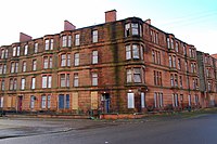

The east side of Allan Street was bombed during the Second World War. Most of the Victorian red sandstone tenements on Dalmarnock Road and Springfield Road[2] were demolished in the 1960s and early-1970s, although some were renovated as part of the Glasgow Eastern Area Renewal (GEAR) scheme in the late 1970s. In the 1960s, a new housing scheme was built, consisting of four twenty-two storey tower blocks and "H-block" maisonettes. Two of the towers, 40 & 50 Millerfield Road, were demolished on 3 February 2002.[6] One other tower was demolished on 1 July 2007, and the final one on 9 September 2007. This physical transformation featured in Chris Leslie's 'Disappearing Glasgow' book.[7]
Dalmarnock was the location chosen for the athletes' village when Glasgow hosted the 2014 Commonwealth Games,[8][9] and by August 2011, there was no remaining housing on Ardenlea Street/Sunnybank Street side of the area,[10][11] due to the preparations and land need for the construction in the area pertaining to the Games and City Legacy.
From 19 May to 2 June 2014, BBC One Scotland aired a documentary entitled "Commonwealth City", narrated by actor Martin Compston, which showed how the people and community in Dalmarnock had been affected since the games were announced in November 2007.[12] The documentary featured local resident Margaret Jaconelli (evicted to make way for the Games),[11] David Stewart (youth and community campaigner)[13][12] Darren Faulds (local entrepreneur) and local councillors George Redmond & Yvonne Kucuk.
The Sir Chris Hoy Velodrome, constructed for the Games, is located at the intersection of Springfield Road, London Road and the Glasgow East End Regeneration Route, opposite Celtic Park football stadium which denotes the district's boundary with Parkhead. A triangular piece of land to the east of the arena was the proposed location of a modern skyscraper, East One; however as of 2020 this site was still undeveloped. To the south of this is the 'Legacy Hub' building, a multi-function community facility belatedly installed to replace the previous hall at Lily Street. It opened in 2015[14][15] but by January 2019 had closed suddenly amid financial problems at the People's Development Trust charity which ran its operations;[16][17] the council purchased the building to secure its future,[18][19] while an investigation found funds had been embezzled by charity leaders including former councillor Yvonne Kucuk.[20]
Clyde Gateway is a large-scale regeneration programme which includes Dalmarnock. It is a partnership between Glasgow City Council, South Lanarkshire Council and Scottish Enterprise, backed by funding and direct support from the Scottish Government.[21] Residential developments in the area following the Commonwealth Games include Riverside,[22][23][24] a project on the site of the former large power station overlooking the river (approximately 550 homes for purchase and social rent),[25] and a site near the railway station (200 homes, in planning as of 2018).[26]
After the departure of all local retailers from the area, all that remained was a small shop which was set up by the workers in the Community Centre; This was a welcome boon for the area residents as the nearest shops were not within walking distance.[27] There is a petrol station on Dalmarnock Road and a car wash, with a pub a short distance further north past the railway station (this has been the location of a licensed premises under various names since the 1830s).[28][29][30] There are also a lot of small business units in the Nuneaton Street area and the Calder Millerfield factory which supplies meat-based products to the fast-food market.
Education edit
The area once had four schools:[2] Springfield Road Primary, Springfield Primary, Riverside Secondary and Our Lady of Fatima RC Primary School on Springfield Road have now closed. There is still a 'Dalmarnock Primary School', but it is situated in nearby Bridgeton and should not be counted among the schools within the area. A new primary school[31] was developed by Glasgow City Council; Riverbank Primary School, opened in August 2019.[32]
Transport edit

Dalmarnock railway station, on the Argyle Line, serves the local area. The station was upgraded for the 2014 Commonwealth Games.[33] Glasgow Corporation Tramways had routes serving the area in the first half of the 20th century, using tracks on Dalmarnock Road, London Road and Springfield Road.[2]
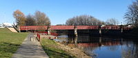
Dalmarnock Railway Bridges edit
There have been two railway bridges in Dalmarnock crossing the River Clyde. The first bridge was built in 1861,[34] and was augmented in 1897[35] by a wider bridge to accommodate the Dalmarnock branch line. The stone pillars of the old bridge are still in situ adjacent to the newer bridge, with the track deck having been removed when it was no longer necessary to have so many lines.<[36] Both bridges were designed by George Graham.[37]
Dalmarnock Bridge edit
There is also a road bridge over the River Clyde on Dalmarnock Road (A749) called Dalmarnock Bridge. The first bridge at the location was wooden, erected in 1821 to connect Dalmarnock and the Farme Cross area of Rutherglen.[38] It was replaced by a new timber bridge in 1848,[39][40] and in 1891 by the current Dalmarnock Bridge, designed by Glasgow consulting engineers, Crouch & Hogg; it is Category B listed.[41]
The Glasgow side of the bridge is a convenient point for walkers and cyclists to join the Clyde Walkway or National Cycle Route 75 which share a tarmac path along the river at this point.
This structure should not be confused with the nearby Rutherglen Bridge which also connects Rutherglen and Dalmarnock (as well as Glasgow Green, Oatlands, Shawfield and Bridgeton), nor with two modern pedestrian bridges: one also connecting to Shawfield, and the other between the 2014 Athletes' Village homes and the Cuningar Loop, an area of open ground on a meander of the river, known locally as 'The Vallies' and converted to a park as part of the area's redevelopment).
Notable people edit
- Professional footballer Kenny Dalglish who played for Celtic F.C. and Liverpool was born in Dalmarnock although he grew up in Milton. He officially opened the Dalmarnock Legacy Hub on 9 October 2015.[14]
- George Chisholm, trombonist, was born in Dalmarnock.[citation needed]
- Glasvegas, rock band.[citation needed]
See also edit
References edit
- ^ Eagle, Andy. "The Online Scots Dictionary". Scots Online. Retrieved 16 March 2019.
- ^ a b c d OS National Grid Maps, 1944-1967, Explore georeferenced maps (National Library of Scotland)
- ^ Glasgow, Dalmarnock Road, Dalmarnock Power Station, Canmore
- ^ Dalmarnock Road Power Station, Glesga Pals
- ^ Dalmarnock Power Station (1955), The Glasgow Story
- ^ "Tower blocks reduced to rubble". 3 February 2002. Retrieved 16 March 2019.
- ^ Mallon, Maggie (29 October 2016). "New book Disappearing Glasgow look at the vanishing 'streets in the sky'". dailyrecord. Retrieved 16 March 2019.
- ^ The Athletes' Village - Glasgow's Bid for the 2014 Commonwealth Games Archived 16 March 2008 at the Wayback Machine
- ^ "Glasgow Athletes' Village in bid to build 125 new homes in tented site". Evening Times. 18 April 2017. Retrieved 30 September 2017.
- ^ Wainwright, Oliver (3 March 2014). "Glasgow faces up to reality of a divided Commonwealth Games legacy". The Guardian. ISSN 0261-3077. Retrieved 16 March 2019.
- ^ a b Summers, Lisa (26 March 2014). "Glasgow 2014: Margaret Jaconelli's story". Retrieved 16 March 2019.
- ^ a b "BBC One - Commonwealth City". BBC. Retrieved 16 March 2019.
- ^ "Youth campaigner resigns from Scottish Labour over arrest row Glasgow councillor". Evening Times. Retrieved 16 March 2019.
- ^ a b "Kenny Dalglish opens £3.5m Dalmarnock Legacy Hub". Evening Times. 9 October 2015. Retrieved 16 March 2019.
- ^ Legacy Hub, Dalmarnock, Clyde Gateway
- ^ Parents' anger at Glasgow nursery closed without notice, BBC News, 27 January 2019
- ^ Commonwealth games legacy hub in Dalmarnock closes after financial problems, Evening Times, 27 January 2019
- ^ Council agrees to buy The Legacy Hub in Dalmarnock, Glasgow City Council, 7 February 2019
- ^ Glasgow to deliver £20m community hubs investment, PBC Today, 6 June 2019
- ^ Ex-Glasgow councillor guilty of taking £8,000 charity cash, BBC News, 30 April 2019
- ^ Home Page, Clyde Gateway
- ^ About the development, Riverside Dalmarnock
- ^ South Dalmarnock Integrated Urban Infrastructure, Sheppard Robson
- ^ Dalmarnock Housing Development Fly-Through Released, McTaggart Group, 4 September 2018
- ^ Homes planned for Dalmarnock Power Station site, BBC News, 28 April 2015
- ^ Plans for over 200 homes to be built on derelict site in east end, Glasgow Live, 5 September 2018
- ^ "Shops axed...so we're locals' lifeline". Senscot. 20 October 2010. Retrieved 16 March 2019.
- ^ The Hayfield, Old Glasgow Pubs
- ^ Still Game's Jane McCarry gets ghostbusting with paranormal investigators at 'haunted' Glasgow pub, Glasgow Live, 22 January 2018
- ^ Dalmarnock boozer tells punters it will now be a Rangers bar ahead of Old Firm, Evening Times, 30 August 2019
- ^ "Community asked to vote for name of new Dalmarnock primary school - and not everyone is happy". Evening Times. 26 January 2018. Retrieved 16 March 2019.
- ^ "Riverbank Primary: Take a tour inside Glasgow's new school". Evening Times. 15 August 2019. Retrieved 19 August 2019.
- ^ Dalmarnock Station Overhaul Archived 27 September 2011 at the Wayback Machine
- ^ Record and images for Dalmarnock Railway Bridge (1861), Canmore
- ^ Record and images for Dalmarnock Railway Bridge (1897), Canmore
- ^ Dalmarnock Railway Bridge, Gazetteer for Scotland. Retrieved 7 January 2022
- ^ "Dalmarnock Railway Bridges". Clyde Waterfront Heritage. Archived from the original on 19 September 2011. Retrieved 11 August 2013.
- ^ The First Dalmarnock Bridge | Glasgow University Library Special Collections, James Hopkirk, The Glasgow Story. Retrieved 7 January 2022
- ^ Record and image (engraving) for Dalmarnock Bridge (1848), Canmore
- ^ Dalmarnock Bridge, Gazetteer for Scotland . Retrieved 7 January 2022
- ^ Record and images for Dalmarnock Bridge, Canmore
External links edit
 Media related to Dalmarnock at Wikimedia Commons
- 'The Legacy', study of Dalmarnock at Disappearing Glasgow
- Parkhead and Dalmarnock, socio-economic profile at Understanding Glasgow (2012)
- Streets of Glesca [East End] at Glesga Pals