


Summary
Darab County (Persian: شهرستان داراب) is in Fars province, Iran. Its capital is the city of Darab.[2]
Darab County
Persian: شهرستان داراب | |
|---|---|
County | |
![Fadami Waterfalls [fa]](http://upload.wikimedia.org/wikipedia/commons/thumb/1/19/Fadami_waterfall_Hadi_Karimi.jpg/250px-Fadami_waterfall_Hadi_Karimi.jpg) Fadami Waterfalls | |
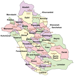 Location of Darab County in Fars province (right, pink) | |
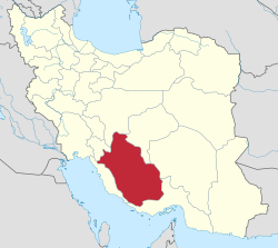 Location of Fars province in Iran | |
| Coordinates: 28°32′N 54°46′E / 28.533°N 54.767°E[1] | |
| Country | |
| Province | Fars |
| Capital | Darab |
| Districts | Central, Fasarud, Forg, Jannat, Rostaq |
| Population (2016) | |
| • Total | 201,489 |
| Time zone | UTC+3:30 (IRST) |
| Darab County can be found at GEOnet Names Server, at this link, by opening the Advanced Search box, entering "9206482" in the "Unique Feature Id" form, and clicking on "Search Database". | |
At the 2006 census, the county's population was 172,938 in 39,955 households.[3] The following census in 2011 counted 189,345 people in 50,595 households,[4] by which time Qaleh Biyaban Rural District, Qaryah ol Kheyr Rural District, and the city of Jannat Shahr had been separated from the Central District in the establishment of Jannat District. At the 2016 census, the county's population was 201,489 in 59,525 households.[5]
Administrative divisions edit
The population history and structural changes of Darab County's administrative divisions over three consecutive censuses are shown in the following table. The latest census shows four districts, 12 rural districts, and four cities.[5]
After the census, Fasarud Rural District and Paskhan Rural District were separated from the Central District in the establishment of Fasarud District.[6] The villages of Rostaq[7] and Paskhan[8] were elevated to the status of cities in 2018 and 2022, respectively.
| Administrative Divisions | 2006[3] | 2011[4] | 2016[5] |
|---|---|---|---|
| Central District | 137,677 | 125,069 | 134,535 |
| Bakhtajerd RD | 8,331 | 9,413 | 9,214 |
| Balesh RD | 10,043 | 12,408 | 14,013 |
| Fasarud RD | 8,531 | 8,479 | 7,819 |
| Hashivar RD | 13,827 | 14,241 | 15,425 |
| Nasrovan RD | 8,098 | 7,935 | 7,333 |
| Paskhan RD | 10,977 | 10,921 | 10,499 |
| Qaleh Biyaban RD | 5,951 | ||
| Qaryah ol Kheyr RD | 6,589 | ||
| Darab (city) | 54,513 | 61,672 | 70,232 |
| Jannat Shahr (city) | 10,817 | ||
| Fasarud District[a] | |||
| Fasarud RD | |||
| Paskhan RD | |||
| Paskhan (city)[b] | |||
| Forg District | 21,020 | 21,600 | 22,138 |
| Abshur RD | 10,639 | 6,950 | 6,897 |
| Forg RD | 10,381 | 7,971 | 8,237 |
| Do Borji (city) | 2,651 | 2,907 | |
| Fadami (city) | 4,028 | 4,097 | |
| Jannat District | 27,645 | 29,852 | |
| Qaleh Biyaban RD | 7,083 | 7,472 | |
| Qaryah ol Kheyr RD | 8,710 | 8,782 | |
| Jannat Shahr (city) | 11,852 | 13,598 | |
| Rostaq District | 14,241 | 14,340 | 14,391 |
| Kuhestan RD | 5,070 | 4,985 | 5,561 |
| Rostaq RD | 9,171 | 9,355 | 8,830 |
| Rostaq (city)[c] | |||
| Total | 172,938 | 189,345 | 201,489 |
| RD = Rural District | |||
Overview edit
It has five hundred villages, and possesses a very hot climate, snow being rarely seen there in winter. Darab city have area of about 7,500 square kilometers and a height of 1180 meters. It produces fruits, cereals, cotton, and tobacco, while the lower areas are used for winter crops by the Baharlu tribe. There are also nearby salt mines which have long been utilized. The town Darab, the capital of the district, is situated in a very fertile plain, 140 mi. S.E. of Shiraz. It has a population (in 2000) of about 60,718 and extensive orchards of orange and lemon trees and immense plantations of date-palms. Legend ascribes the foundation of the city to Darius, hence its name Darab-gerd ("Darius-fort").
In the neighborhood there are various remains of antiquity, the most important of which mi. S., is known as the Kalah i Dal-a, or citadel of Darius, and consists of a series of earthworks arranged in a circle round an isolated rock. Nothing, however, remains to fix the date or explain the history of the fortification. Another monument in the vicinity is a gigantic bas-relief, carved on the vertical face of a rock, representing the victory of the Sassanian Shapur I (Sapor) of Persia over the Roman emperor Valerian, A.D. 260.
Notes edit
References edit
- ^ OpenStreetMap contributors (15 September 2023). "Darab County" (Map). OpenStreetMap. Retrieved 15 September 2023.
- ^ Habibi, Hassan (21 June 1369). "Approval of the organization and chain of citizenship of the elements and units of the national divisions of Fars province, centered in Shiraz". Lamtakam (in Persian). Ministry of Interior, Council of Ministers. Archived from the original on 7 December 2023. Retrieved 7 December 2023.
- ^ a b "Census of the Islamic Republic of Iran, 1385 (2006)". AMAR (in Persian). The Statistical Center of Iran. p. 07. Archived from the original (Excel) on 20 September 2011. Retrieved 25 September 2022.
- ^ a b "Census of the Islamic Republic of Iran, 1390 (2011)" (Excel). Iran Data Portal (in Persian). The Statistical Center of Iran. p. 07. Retrieved 19 December 2022.
- ^ a b c "Census of the Islamic Republic of Iran, 1395 (2016)". AMAR (in Persian). The Statistical Center of Iran. p. 07. Archived from the original (Excel) on 6 April 2022. Retrieved 19 December 2022.
- ^ Jahangiri, Ishaq (22 December 1397). "Letter of approval regarding the creation of Fasarud District, with the center of the village of Paskhan, from the combination of Fasarud and Paskhan Rural Districst in Darab County of Fars province". Qavanin (in Persian). Ministry of Interior, Council of Ministers. Archived from the original on 15 September 2023. Retrieved 15 September 2023.
- ^ a b "Rastaq joined the cities of Fars". IRIB News (in Persian). Sada and Sima News Agency. 16 March 2018. Archived from the original on 25 September 2019. Retrieved 17 April 2024.
- ^ a b "The first responsible mayor of Darab, Fars, was introduced". Islamic Republic News Agency (in Persian). Ministry of Interior. 12 June 2022. Archived from the original on 13 June 2022. Retrieved 17 April 2024.