


Summary
Darbhanga district is one of the thirty-eight districts of Bihar state in eastern India, and Darbhanga city is the administrative headquarters of this district and 5th largest city of Bihar as well. Darbhanga district lies in Historical Mithila region. Darbhanga district is a part of Darbhanga Division. The district is bounded on the north by Madhubani district, on the south by Samastipur district, on the east by Saharsa district and on the west by Sitamarhi and Muzaffarpur districts. The district covers an area of 2,279 km2 (880 sq mi).
Darbhanga district | |
|---|---|
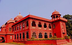 Lalit Narayan Mithila University, Darbhanga | |
 Location of Darbhanga district in Bihar | |
| Country | |
| State | Bihar |
| Region | Mithila |
| Division | Darbhanga |
| Headquarters | Darbhanga |
| Government | |
| • Lok Sabha constituencies | Darbhanga |
| • Member of Parliament, Lok Sabha | Gopal Jee Thakur, BJP |
| • District Magistrate | Shri Rajiv Raushan(IAS) |
| • Senior Superintendent of Police | Shri Awakash Kumar(IPS) |
| • Vidhan Sabha constituencies | Kusheshwar Asthan, Gaura Bauram, Benipur, Alinagar, Darbhanga Rural, Darbhanga, Hayaghat, Bahadurpur, Keoti, Jale |
| Area | |
| • Total | 2,279 km2 (880 sq mi) |
| Population (2011) | |
| • Total | 3,937,385 |
| • Density | 1,700/km2 (4,500/sq mi) |
| • Urban | 8.7 per cent |
| Demographics | |
| • Literacy | 56.56 per cent |
| • Sex ratio | 1024 |
| Time zone | UTC+05:30 (IST) |
| Major highways | NH 27, NH 527B |
| Website | darbhanga |
History edit
1976 saw the creations of two districts from Darbhanga's territory: Madhubani and Samastipur.[1]
Block and circle edit

- Darbhanga Assembly constituency
- Baheri Assembly constituency
- Biraul Assembly constituency
- Keoti Assembly constituency
- Singhwara Assembly constituency
- Jale Assembly constituency
- Bahadurpur Assembly constituency
- Benipur Assembly constituency
- Manigachhi Assembly constituency
- Kusheshwar Asthan
- Kusheshwar Asthan Purbi
- Hanuman nagar Assembly constituency
- Gaura Bauram Assembly constituency
- Hayaghat Assembly constituency
- Alinagar Assembly constituency
- Ghanshyampur Assembly constituency
- Taradih Assembly constituency
- Kiratpur Assembly constituency
Geography edit
Darbhanga district occupies an area of 2,279 square kilometres (880 sq mi),[3] comparatively equivalent to Indonesia's Yapen Island.[4]
Economy edit
In 2006, the Ministry of Panchayati Raj named Darbhanga one of the country's 250 most backward districts (out of a total of 640).[5] It is one of the 36 districts in Bihar currently receiving funds from the Backward Regions Grant Fund Programme (BRGF).[5]
Demographics edit
| Year | Pop. | ±% p.a. |
|---|---|---|
| 1901 | 889,022 | — |
| 1911 | 894,232 | +0.06% |
| 1921 | 889,302 | −0.06% |
| 1931 | 966,393 | +0.83% |
| 1941 | 1,055,208 | +0.88% |
| 1951 | 1,150,582 | +0.87% |
| 1961 | 1,337,802 | +1.52% |
| 1971 | 1,622,812 | +1.95% |
| 1981 | 2,008,193 | +2.15% |
| 1991 | 2,510,959 | +2.26% |
| 2001 | 3,295,789 | +2.76% |
| 2011 | 3,937,385 | +1.79% |
| source:[6] | ||
According to the 2011 census, Darbhanga district has a population of 3,937,385,[8] roughly equal to the nation of Liberia[9] or the US state of Oregon.[10] This gives it a ranking of 64th in India (out of a total of 640). The district has a population density of 1,721 inhabitants per square kilometre (4,460/sq mi). Its population growth rate over the decade 2001-2011 was 19%. Literacy rate of the district is 56.56% (male 66.83%, female 45.24%). 9.74% of the population lives in urban areas. Scheduled Castes and Scheduled Tribes make up 15.64% and 0.07% of the population respectively.
At the time of the 2011 Census of India, 72.75% of the population in the district spoke Maithili, 20.67% Urdu and 5.96% Hindi as their first language.[11]
Health edit
The table below shows the data from the district nutrition profile of children below the age of 5 years, in Darbhanga, as of year 2020.
| Indicators | Number of children (<5 years) | Percent (2020) | Percent (2016) |
|---|---|---|---|
| Stunted | 255,374 | 45% | 49% |
| Wasted | 108,562 | 19% | 17% |
| Severely wasted | 36,000 | 6% | 5% |
| Underweight | 220,499 | 39% | 41% |
| Overweight/obesity | 8,494 | 2% | 2% |
| Anemia | 348,147 | 69% | 70% |
| Total children | 562,497 |
The table below shows the district nutrition profile of Darbhanga of women between the ages of 15 to 49 years, as of year 2020.
| Indicators | Number of women (15–49 years) | Percent (2020) | Percent (2016) |
|---|---|---|---|
| Underweight (BMI <18.5 kg/m^2) | 293,595 | 26% | 31% |
| Overweight/obesity | 154,023 | 13% | 12% |
| Hypertension | 200,126 | 17% | 11% |
| Diabetes | 154,596 | 13% | NA |
| Anemia (non-preg) | 703,022 | 61% | 66% |
| Anemia (preg) | 74,677 | 53% | 62% |
| Total women (preg) | 142,241 | ||
| Total women | 1,146,855 |
Politics edit
Currently Gopal Jee Thakur of Bhartiya Janta Party is the Member of Parliament from Darbhanga Lok Sabha Constituency.[13][14]
| District | No. | Constituency | Name | Party | Alliance | Remarks | ||
|---|---|---|---|---|---|---|---|---|
| Darbhanga | 78 | Kusheshwar Asthan | Shashi Bhushan Hazari | JD(U) | NDA | Died in 1 July 2021 | ||
| Aman Bhushan Hajari | Elected on 2 November 2021 in by-election | |||||||
| 79 | Gaura Bauram | Swarna Singh | BJP | NDA | Switched from VIP to BJP[15] | |||
| 80 | Benipur | Binay Kumar Choudhary | JD(U) | NDA | ||||
| 81 | Alinagar | Mishrilal Yadav | BJP | NDA | Switched from VIP to BJP[16] | |||
| 82 | Darbhanga Rural | Lalit Kumar Yadav | RJD | MGB | ||||
| 83 | Darbhanga | Sanjay Saraogi | BJP | NDA | ||||
| 84 | Hayaghat | Ram Chandra Prasad | BJP | NDA | ||||
| 85 | Bahadurpur | Madan Sahni | JD(U) | NDA | ||||
| 86 | Keoti | Murari Mohan Jha | BJP | NDA | ||||
| 87 | Jale | Jibesh Kumar | BJP | NDA | ||||
See also edit
References edit
- ^ Law, Gwillim (25 September 2011). "Districts of India". Statoids. Retrieved 11 October 2011.
- ^ "Blocks in Darbhanga District, Bihar".
- ^ Srivastava, Dayawanti, ed. (2010). "States and Union Territories: Bihar: Government". India 2010: A Reference Annual (54th ed.). New Delhi, India: Additional Director General, Publications Division, Ministry of Information and Broadcasting (India), Government of India. pp. 1118–1119. ISBN 978-81-230-1617-7.
- ^ "Island Directory Tables: Islands by Land Area". United Nations Environment Program. 18 February 1998. Archived from the original on 20 February 2018. Retrieved 11 October 2011.
Yapen 2,278km2
- ^ a b Ministry of Panchayati Raj (8 September 2009). "A Note on the Backward Regions Grant Fund Programme" (PDF). National Institute of Rural Development. Archived from the original (PDF) on 5 April 2012. Retrieved 27 September 2011.
- ^ "Table A-02 Decadal Variation in Population Since 1901: Bihar" (PDF). census.gov.in. Registrar General and Census Commissioner of India.
- ^ "Table C-01 Population by Religion: Bihar". censusindia.gov.in. Registrar General and Census Commissioner of India. 2011.
- ^ "District Census Handbook: Darbhanga" (PDF). Census of India. Registrar General and Census Commissioner of India. 2011.
- ^ US Directorate of Intelligence. "Country Comparison:Population". Archived from the original on 27 September 2011. Retrieved 1 October 2011.
Liberia 3,786,764 July 2011 est.
- ^ "2010 Resident Population Data". U. S. Census Bureau. Archived from the original on 19 October 2013. Retrieved 30 September 2011.
Oregon 3,831,074
- ^ a b "Table C-16 Population by Mother Tongue: Bihar". censusindia.gov.in. Registrar General and Census Commissioner of India. 2011.
- ^ a b https://www.niti.gov.in/sites/default/files/2022-06/Darbhanga-Bihar.pdf [bare URL PDF]
- ^ "Shri Gopal Jee Thakur| National Portal of India". www.india.gov.in. Retrieved 3 March 2023.
- ^ "Members : Lok Sabha". loksabha.nic.in. Retrieved 3 March 2023.
- ^ "All 3 VIP MLAs join BJP in Bihar making it the largest party in Assembly". The Hindu. 23 March 2022. ISSN 0971-751X. Retrieved 23 March 2022.
- ^ "All 3 VIP MLAs join BJP in Bihar making it the largest party in Assembly". The Hindu. 23 March 2022. ISSN 0971-751X. Retrieved 23 March 2022.
External links edit
- Darbhanga district website
26°00′N 86°00′E / 26.000°N 86.000°E