


Summary
Darlag County (Tibetan: དར་ལག་རྫོང; Chinese: 达日县) is a county of southeastern Qinghai province, China, bordering Sichuan to the south and west. It is under the administration of Golog Tibetan Autonomous Prefecture. The county seat is in the Town of Gyümai.
Darlag County
达日县 · དར་ལག་རྫོང Dari | |
|---|---|
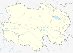
 Darlag County (light red) within Golog Prefecture (yellow) and Qinghai | |
 Darlag Location of the seat in Qinghai | |
| Coordinates: 33°24′N 99°20′E / 33.400°N 99.333°E | |
| Country | China |
| Province | Qinghai |
| Autonomous prefecture | Golog |
| County seat | Gyümai |
| Area | |
| • Total | 14,800 km2 (5,700 sq mi) |
| Population (2020)[1] | |
| • Total | 40,197 |
| • Density | 2.7/km2 (7.0/sq mi) |
| Time zone | UTC+8 (China Standard) |
| Website | www |
| Darlag County | |||||||
|---|---|---|---|---|---|---|---|
| Chinese name | |||||||
| Simplified Chinese | 达日县 | ||||||
| Traditional Chinese | 達日縣 | ||||||
| |||||||
| Tibetan name | |||||||
| Tibetan | དར་ལག་རྫོང | ||||||
| |||||||
Geography and Climate edit
With an elevation of around 3,970 metres (13,020 ft), Darlag County has an alpine climate (Köppen ET), bordering on a subalpine climate (Köppen Dwc), with long, very cold winters, and short, rainy, cool summers. Average low temperatures are below freezing from mid September to late May; however, due to the wide diurnal temperature variation, average highs are only below freezing from mid/late November thru early March. With monthly percent possible sunshine ranging from 47% in June to 70% in November, the county seat receives 2,467 hours of bright sunshine annually. The monthly 24-hour average temperature ranges from −12.0 °C (10.4 °F) in January to 9.8 °C (49.6 °F) in July, while the annual mean is −0.53 °C (31.0 °F). Over 70% of the annual precipitation of 558 mm (22.0 in) is delivered from June to September.
| Climate data for Darlag County (1991–2020 normals, extremes 1971–2010) | |||||||||||||
|---|---|---|---|---|---|---|---|---|---|---|---|---|---|
| Month | Jan | Feb | Mar | Apr | May | Jun | Jul | Aug | Sep | Oct | Nov | Dec | Year |
| Record high °C (°F) | 11.9 (53.4) |
10.4 (50.7) |
14.7 (58.5) |
18.3 (64.9) |
21.6 (70.9) |
21.9 (71.4) |
24.3 (75.7) |
24.4 (75.9) |
23.3 (73.9) |
20.9 (69.6) |
10.6 (51.1) |
10.1 (50.2) |
24.4 (75.9) |
| Mean daily maximum °C (°F) | −2.4 (27.7) |
0.1 (32.2) |
3.4 (38.1) |
7.7 (45.9) |
11.3 (52.3) |
14.1 (57.4) |
16.6 (61.9) |
16.5 (61.7) |
13.6 (56.5) |
7.7 (45.9) |
2.6 (36.7) |
−1.2 (29.8) |
7.5 (45.5) |
| Daily mean °C (°F) | −11.8 (10.8) |
−8.4 (16.9) |
−4.2 (24.4) |
0.7 (33.3) |
4.5 (40.1) |
8.0 (46.4) |
10.1 (50.2) |
9.5 (49.1) |
6.5 (43.7) |
0.6 (33.1) |
−5.9 (21.4) |
−10.9 (12.4) |
−0.1 (31.8) |
| Mean daily minimum °C (°F) | −19.5 (−3.1) |
−15.8 (3.6) |
−10.4 (13.3) |
−4.9 (23.2) |
−0.7 (30.7) |
3.3 (37.9) |
5.0 (41.0) |
4.2 (39.6) |
1.7 (35.1) |
−4.1 (24.6) |
−12.2 (10.0) |
−18.5 (−1.3) |
−6.0 (21.2) |
| Record low °C (°F) | −31.4 (−24.5) |
−30.3 (−22.5) |
−26.4 (−15.5) |
−16.1 (3.0) |
−10.8 (12.6) |
−4.8 (23.4) |
−3.4 (25.9) |
−5.2 (22.6) |
−7.8 (18.0) |
−17.8 (0.0) |
−25.5 (−13.9) |
−34.0 (−29.2) |
−34.0 (−29.2) |
| Average precipitation mm (inches) | 6.8 (0.27) |
8.3 (0.33) |
16.3 (0.64) |
28.8 (1.13) |
66.7 (2.63) |
112.6 (4.43) |
113.0 (4.45) |
96.3 (3.79) |
80.5 (3.17) |
34.2 (1.35) |
5.8 (0.23) |
3.4 (0.13) |
572.7 (22.55) |
| Average precipitation days (≥ 0.1 mm) | 7.0 | 7.8 | 12.0 | 14.1 | 19.3 | 21.6 | 20.4 | 18.1 | 19.4 | 14.9 | 5.3 | 4.3 | 164.2 |
| Average snowy days | 8.8 | 10.3 | 14.8 | 16.2 | 15.6 | 3.7 | 0.8 | 0.8 | 4.9 | 14.6 | 7.1 | 6.2 | 103.8 |
| Average relative humidity (%) | 50 | 49 | 52 | 56 | 63 | 69 | 70 | 70 | 72 | 67 | 55 | 49 | 60 |
| Mean monthly sunshine hours | 192.3 | 178.9 | 209.8 | 225.5 | 214.0 | 186.5 | 216.3 | 216.1 | 189.1 | 198.8 | 208.1 | 203.5 | 2,438.9 |
| Percent possible sunshine | 61 | 57 | 56 | 57 | 49 | 43 | 50 | 53 | 52 | 57 | 68 | 66 | 56 |
| Source: China Meteorological Administration[2][3][4] | |||||||||||||
Administrative divisions edit
Darlag is divided into 1 town and 9 townships:
| Name | Simplified Chinese | Hanyu Pinyin | Tibetan | Wylie | Administrative division code | |
|---|---|---|---|---|---|---|
| Town | ||||||
| Gyümai Town (Jimai) |
吉迈镇 | Jímài Zhèn | རྒྱུ་སྨད་གྲོང་རྡལ། | rgyu smad grong rdal | 632624100 | |
| Townships | ||||||
| Marzhing Township (Manzhang) |
满掌乡 | Mǎnzhǎng Xiāng | སྨར་འབྲིང་ཡུལ་ཚོ། | smar 'bring yul tsho | 632624200 | |
| Dêrnang Township (De'ang) |
德昂乡 | Dé'áng Xiāng | སྡེར་ནང་ཡུལ་ཚོ། | sder nang yul tsho | 632624201 | |
| Oisêr Township (Wosai) |
窝赛乡 | Wōsài Xiāng | འོད་ཟེར་ཡུལ་ཚོ། | 'od zer yul tsho | 632624202 | |
| Boiba Township (Moba) |
莫坝乡 | Mòbà Xiāng | འབོ་པ་ཡུལ་ཚོ། | 'bo pa yul tsho | 632624203 | |
| Boingor Doima Township (Shanghongke) |
上红科乡 | Shànghóngkē Xiāng | དཔོན་སྒོར་སྟོད་མ་ཞང་། | dpon sgor stod ma zhang | 632624204 | |
| Boingor Mangma Township (Xiahongke) |
下红科乡 | Xiàhóngkē Xiāng | དཔོན་སྐོར་སྨང་མ་ཡུལ་ཚོ། | dpon sgor smang ma yul tsho | 632624205 | |
| Zugzhün Township (Jianshe) |
建设乡 | Jiànshè Xiāng | འཛུགས་སྐྲུན་ཡུལ་ཚོ། | 'dzugs skrun yul tsho | 632624206 | |
| Sangrima Township (Sangrima, Sangruma) |
桑日麻乡 | Sāngrìmá Xiāng | གསང་རི་མ་ཡུལ་ཚོ། | gsang ri ma yul tsho | 632624207 | |
| Dagtog Township (Tehetu) |
特合土乡 | Tèhétǔ Xiāng | སྟག་ཐོག་ཡུལ་ཚོ། | stag thog yul tsho | 632624208 | |
See also edit
References edit
- ^ "果洛州第七次全国人口普查公报(第二号)——县级常住人口情况" (in Chinese). Government of Hainan Prefecture. 2021-07-09.
- ^ 中国气象数据网 – WeatherBk Data (in Simplified Chinese). China Meteorological Administration. Retrieved 27 September 2023.
- ^ 中国气象数据网 (in Simplified Chinese). China Meteorological Administration. Retrieved 27 September 2023.
- ^ 中国地面国际交换站气候标准值月值数据集(1971-2000年). China Meteorological Administration. Archived from the original on 2013-09-21. Retrieved 2010-05-25.
External links edit
- County Government's official website