


Summary
Dayr 'Amr was a Palestinian Arab village in the Jerusalem Subdistrict. It was depopulated during the 1948 Arab-Israeli War on July 17, 1948, by the Fourth Battalion of the Har'el Brigade, during the second stage of Operation Dan. It was located 12.5 km west of Jerusalem. Dayr 'Amr was named after a local sage known by al-Sa'i 'Amr and a shrine was in the village dedicated to him.
Dayr 'Amr
دير عمرو | |
|---|---|
Village | |
| Etymology: Kh. Deir 'Amr, the ruin of the monastery of Amr[1] | |
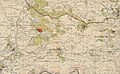
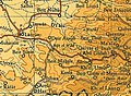
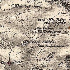 1870s map 1870s map 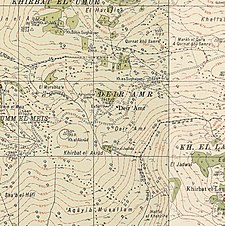 1940s map 1940s map modern map modern map  1940s with modern overlay map 1940s with modern overlay mapA series of historical maps of the area around Dayr 'Amr (click the buttons) | |
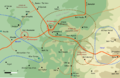
 Dayr 'Amr Location within Mandatory Palestine | |
| Coordinates: 31°46′37″N 35°05′48″E / 31.77694°N 35.09667°E | |
| Palestine grid | 159/131 |
| Geopolitical entity | Mandatory Palestine |
| Subdistrict | Jerusalem |
| Date of depopulation | July 17, 1948 |
| Area | |
| • Total | 3,072 dunams (3.072 km2 or 1.186 sq mi) |
| Population (1945) | |
| • Total | 10[2][3] |
| Current Localities | Eitanim[4] |
History edit
In 1863, Victor Guérin found here a wali, devoted to a Sheikh Amer, and this wali gave name to the neighbouring "ruin", which he described as "twenty small chambers, half of which have been collapsed and enclosed within the same enclosure: they were constructed with materials of all kinds and date from the Middle Ages." He also noted five cisterns had been excavated from the rock, and appeared to be older.[5]
In 1883, the PEF's Survey of Western Palestine found "ruined walls" at Khurbet Deir 'Amr.[6]
British Mandate era edit
In the 1922 census of Palestine, conducted by the British Mandate authorities, Dair Amr had a population 5, all Muslims,[7] while in the 1931 census, it was counted with Suba, and together they had a population of 434 Muslims, in 110 houses.[8]
Freya Stark recalled how she met with Ahmad Samih Khalidi, the principal of Arab College (Jerusalem), and "his charming Syrian wife" and inspected the orphanage which was built at Dayr 'Amr. The first £ 1,000 was collected among fourteen Arabs of Jerusalem, who started it in 1940. They built a school, a farm, and a directors house in "strong stone" at the top of a stony hill. The student learned agriculture, which they could use when they returned to their villages.[9]
In the 1945 statistics only 10 Muslims were recorded,[2] with a total of 3,072 dunums of land.[3] Of this, 18 dunams were for irrigable land or plantations, 650 for cereals,[10] while 2,404 dunams were non-cultivable land.[11]
1948, aftermath edit
In 1952, the buildings of the boys' farm were transformed into the Israeli mental hospital Eitanim[4]
In 1992, the place was described in the following terms: "The site is surrounded with a fence and a guarded gate. All the houses still stand and new extensions have been added to some of them. Large cypress and carob trees grow among the houses. There is an olive grove on the southern edge of the village. The Bezek telephone and television company has established a large facility, with radar equipment, at the southern edge of the site. The psychiatric hospital of Eytanim is nearby."[12]
-
 Dayr 'Amr 1943 1:20,000 (bottom left)
 -
 Dayr 'Amr 1945 1:250,000
 -
 Dayr 'Amr May 10 1948
 -
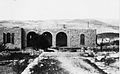
 Deir 'Amr orphanage after capture, 1948
 -
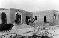
 Deir 'Amr orphanage July 1948
 -
 Deir 'Amr orphanage occupied by the Harel Brigade
 -
 Road to Deir 'Amr, July 1948
 -
 Members of Yiftach Brigade outside Dayr 'Amr. 1948


References edit
- ^ Palmer, 1881, p. 303
- ^ a b Department of Statistics, 1945, p. 24
- ^ a b Government of Palestine, Department of Statistics. Village Statistics, April, 1945. Quoted in Hadawi, 1970, p. 56
- ^ a b Khalidi, 1992, p. 284
- ^ Guérin, 1869, p. 8
- ^ Conder and Kitchener, 1883, p. 111
- ^ Barron, 1923, Table VII, Sub-district of Jerusalem, p. 14
- ^ Mills, 1932, p. 43
- ^ Stark, 1945, pp.105–106
- ^ Government of Palestine, Department of Statistics. Village Statistics, April, 1945. Quoted in Hadawi, 1970, p. 102
- ^ Government of Palestine, Department of Statistics. Village Statistics, April, 1945. Quoted in Hadawi, 1970, p. 152
- ^ Khalidi, 1992, p. 285
References edit
- Barron, J. B., ed. (1923). Palestine: Report and General Abstracts of the Census of 1922. Government of Palestine.
- Conder, C.R.; Kitchener, H. H. (1883). The Survey of Western Palestine: Memoirs of the Topography, Orography, Hydrography, and Archaeology. Vol. 3. London: Committee of the Palestine Exploration Fund.
- Department of Statistics (1945). Village Statistics, April, 1945. Government of Palestine.
- Guérin, V. (1869). Description Géographique Historique et Archéologique de la Palestine (in French). Vol. 1: Judee, pt. 2. Paris: L'Imprimerie Nationale.
- Hadawi, S. (1970). Village Statistics of 1945: A Classification of Land and Area ownership in Palestine. Palestine Liberation Organization Research Center.
- Khalidi, W. (1992). All That Remains: The Palestinian Villages Occupied and Depopulated by Israel in 1948. Washington D.C.: Institute for Palestine Studies. ISBN 0-88728-224-5.
- Mills, E., ed. (1932). Census of Palestine 1931. Population of Villages, Towns and Administrative Areas. Jerusalem: Government of Palestine.
- Morris, B. (2004). The Birth of the Palestinian Refugee Problem Revisited. Cambridge University Press. ISBN 978-0-521-00967-6.
- Palmer, E. H. (1881). The Survey of Western Palestine: Arabic and English Name Lists Collected During the Survey by Lieutenants Conder and Kitchener, R. E. Transliterated and Explained by E.H. Palmer. Committee of the Palestine Exploration Fund.
- Stark, F. (1945). East is West. John Murray.
External links edit
- Welcome To Dayr 'Amr
- Dayr 'Amr, Zochrot
- Survey of Western Palestine, Map 17: IAA, Wikimedia commons
- Dayr 'Amr from the Khalil Sakakini Cultural Center